
चित्र:Ancient Orient.png

यस पूर्व रुपको आकार: ८०० × ५१६ पिक्सल। अरु संकल्पहरू: ३२० × २०६ पिक्सल • ६४० × ४१३ पिक्सल • १,०२४ × ६६१ पिक्सल • १,२८० × ८२६ पिक्सल • २,५६० × १,६५२ पिक्सल • ४,३६५ × २,८१६ पिक्सल।
मूल फाइल (४,३६५ × २,८१६ पिक्सेलहरू, फाइल आकार: १०.१८ मेगाबाइटहरू, MIME प्रकार: image/png)
| यो विकिमीडिया कमन्सको चित्र हो। त्यहाँ यसको विवरण पृष्ठबाट जानकारी तल देखाइएको छ। कमन्स स्वतन्त्र रूपमा इजाजतपत्र प्राप्त चित्र भण्डार हो। तपाईंले मद्दत गर्न सक्नुहुन्छ। |
सारांश
| वर्णन |
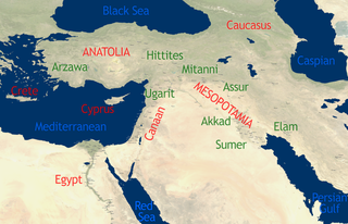
English: See Image:Orient 27 43 22 55 blank map.png for a blank map.
self-created in November 2004 on the basis of the 2002 NASA Blue Marble image.[1] |
| मिति | १५ नोभेम्बर २००४ (original upload date) |
| स्रोत | This compound image uses free material land_shallow_topo_east.tif from NASA Visible Earth (formerly "Blue Marble") and world.200407.3x21600x21600.C1.png from JULY, BLUE MARBLE NEXT GENERATION |
| लेखक | Dbachmann and Cush at en.wikipedia |
अनुज्ञा प्राप्त गर्दै
For the current map
| This work has been released into the public domain by its author, Cush. This applies worldwide. In some countries this may not be legally possible; if so: |
For the previous map
| This work has been released into the public domain by its author, Dbachmann at अङ्ग्रेजी विकिपीडिया. This applies worldwide. In some countries this may not be legally possible; if so: Dbachmann grants anyone the right to use this work for any purpose, without any conditions, unless such conditions are required by law. |
Original upload log
The original description page was here. All following user names refer to en.wikipedia.
- 2004-11-15 08:40 Dbachmann 429×274×8 (213130 bytes) {{PD}}
फाइल इतिहास
मिति/समय मा क्लिक गरेर त्यससमयमा यो फाइल कस्तो थियो भनेर हेर्न सकिन्छ ।
| मिति/समय | छोटो चित्र | आकारहरू | प्रयोगकर्ता | टिप्पणी | |
|---|---|---|---|---|---|
| हालको | १९:१९, २२ अक्टोबर २०१० | | ४,३६५×२,८१६ (१०.१८ मेगाबाइटहरू) | Cush | Enhanced and enlarged version with city names and locations. Unfortunately the map had to be scaled to 88% of the original (due to size constraints on WP) so that the city labels are a little blurred. |
| १९:१०, २२ अक्टोबर २०१० |  | ४२९×२७४ (२०८ किलोबाइटहरू) | Cush | restored previous version, grrr | |
| १९:०४, २२ अक्टोबर २०१० |  | ४,९६०×३,२०० (१२.११ मेगाबाइटहरू) | Cush | Enhanced and enlarged version with city names and locations | |
| ०७:१०, २५ जुलाई २००८ |  | ४२९×२७४ (२०८ किलोबाइटहरू) | File Upload Bot (Magnus Manske) | {{BotMoveToCommons|en.wikipedia}} {{Information |Description={{en|see en::Image:Orient 27 43 22 55 blank map.png for a blank map. self-created in November 2004 on the basis of the 2002 NASA en:Blue Marble image.[http://earthobservatory.nasa. |
फाइल प्रयोग
यस फाइलमा निम्न पृष्ठ जोडिन्छ:
विश्वव्यापी फाइल प्रयोग
निम्न अन्य विकिहरूमा यस फाइलको प्रयोग:
- af.wikipedia.org मा उपयोग
- am.wikipedia.org मा उपयोग
- ar.wikipedia.org मा उपयोग
- arz.wikipedia.org मा उपयोग
- be-tarask.wikipedia.org मा उपयोग
- be.wikipedia.org मा उपयोग
- bn.wikipedia.org मा उपयोग
- ca.wikipedia.org मा उपयोग
- cs.wikipedia.org मा उपयोग
- en.wikipedia.org मा उपयोग
- Talk:Arabic
- Talk:Delian League
- Talk:Adamic language
- Talk:Alyattes of Lydia
- Talk:Bible
- Talk:Biblical canon
- Talk:Books of the Bible
- Talk:Behistun Inscription
- Talk:Battle of Marathon
- Talk:Cassandra
- Talk:Anti-Semitism in Christianity
- Talk:Dragon
- Talk:Epistle of James
- Talk:Book of Genesis
- Talk:Hebrew alphabet
- Talk:History of ancient Israel and Judah
- Talk:Religion in pre-Islamic Arabia
- Talk:Jerusalem
- Talk:Japheth
- Talk:Lucifer
- Talk:New Testament
- Talk:Old Testament
- Talk:Roman Empire
- Talk:Resurrection of Jesus
- Talk:Satan
- Talk:Temple in Jerusalem
- Talk:Names of God in Judaism
- Talk:Great Tribulation
- Talk:Matthias the Apostle
- Talk:Acre, Israel
- Talk:Nevi'im
- Talk:Cambyses II
- Talk:Gospel of Luke
- Talk:Tantalus
- Talk:Semitic languages
- Talk:Kingdom of Kush
- Talk:Zoroastrianism
- Talk:Babylonia and Assyria
- Talk:History of the ancient Levant
- Talk:Judas Iscariot
यस फाइलको विश्वव्यापी उपयोगको अधिक जानकारी हेर्नुहोस् ।