
चित्र:Bhutan - Location Map (2013) - BTN - UNOCHA.svg

मूल फाइल (SVG फाइल,साधारण २५० × २५० पिक्सेलहरु, फाइल आकार: ५२० किलोबाइटहरू)
| यो विकिमीडिया कमन्सको चित्र हो। त्यहाँ यसको विवरण पृष्ठबाट जानकारी तल देखाइएको छ। कमन्स स्वतन्त्र रूपमा इजाजतपत्र प्राप्त चित्र भण्डार हो। तपाईंले मद्दत गर्न सक्नुहुन्छ। |
_-_BTN_-_UNOCHA.svg)
Arunachal Pradesh shown separately is integral part of India.
सारांश
| वर्णन |
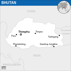
English: Locator map of Bhutan. |
| मिति | |
| स्रोत |
English: Bhutan Locator Map (ReliefWeb), ESRI, UNCS, The Times Atlas of the World |
| लेखक | |
| SVG genesis |
अनुज्ञा प्राप्त गर्दै
- तपाईं स्वतन्त्र हुनुहुन्छ :
- साझेदारी गर्नुहाेस् – रचनालाई कपी, वितरित तथा संचारित गर्नको लागि
- रिमिक्स गर्नको लागि – काम अनुकूलित गर्नको लागि
- निम्नलिखित कारणहरूको अन्तर्गत:
- एट्रिब्युसन – तपाईंले रचनाको श्रेय अनुमतिपत्रकर्ता अथवा लेखकले बताएको माध्यमले दिनु पर्नेछ (तर यस प्रकार हैन, जसमा लागोस् की उ तपाईंलाई अथवा तपाईंको रचनाको प्रयोगलाई समर्थन गर्छन्)।
 This map is part of a collection of 216 free country maps, created by the UN Office for the Coordination of Humanitarian Affairs (OCHA), to be used in print, web or broadcast products.
The ReliefWeb Location Maps released here are maps that highlight a country, its capital, major populated places and the surrounding regions. Attribution Requirements
Using the map without modifications: ensure that the sources and the disclaimer are below the map. Credit as follows: "Credit: OCHA". For use with alteration: remove the OCHA logo and disclaimer following any modification to the map, but keep the data sources as mentioned below the map. Credit the modified map as follows: "Based on OCHA map". You are responsible for the content of your map. We are keen to receive your feedback and hear how you used OCHA's maps. We would be grateful if you would notify us by e-mail and share your work with us. UN Disclaimer
The designations employed and the presentation of material of this map do not imply the expression of any opinion whatsoever on the part of the Secretariat of the United Nations concerning the legal status of any country, territory, city or area or of its authorities or concerning the delimitation of its frontiers or boundaries. |

|
Textual information (e.g. timestamp) once visible in the image itself has been moved into the image metadata and/or image description page. This makes the image easier to reuse and more language-neutral, and makes the text easier to process and search for. Commons discourages placing visible textual information in images. All licenses accepted on Commons permit this type of modification as a derivative work.
If attribution information were removed and the image is not public domain, replace this tag with {{Attribution metadata from licensed image}}.
|
फाइल इतिहास
मिति/समय मा क्लिक गरेर त्यससमयमा यो फाइल कस्तो थियो भनेर हेर्न सकिन्छ ।
| मिति/समय | छोटो चित्र | आकारहरू | प्रयोगकर्ता | टिप्पणी | |
|---|---|---|---|---|---|
| हालको | ०५:२३, २६ डिसेम्बर २०२२ | | २५०×२५० (५२० किलोबाइटहरू) | Wikijahnn | File uploaded using svgtranslate tool (https://svgtranslate.toolforge.org/). Added translation for ca. |
| ०७:०२, १९ नोभेम्बर २०२२ |  | २५०×२५० (५२० किलोबाइटहरू) | Pengetik-AM | File uploaded using svgtranslate tool (https://svgtranslate.toolforge.org/). Added translation for id. | |
| ११:५७, ५ जनवरी २०१६ |  | २५०×२५० (५१९ किलोबाइटहरू) | Wereldburger758 | Resized page to drawing. Removal watermark. Validation of image. | |
| ०४:२८, १४ मार्च २०१४ |  | २५४×२५४ (५१४ किलोबाइटहरू) | UN OCHA maps bot | == {{int:filedesc}} == {{Information |description={{en|1=Locator Map of Bhutan. {{OCHA map}}}} |date=2013 |source=[http://reliefweb.int/map/bhutan/bhutan-location-map-2013 Bhutan Locator Map (ReliefWeb)] |author=[[w:United Nations Office f... |
फाइल प्रयोग
यो फाइलसँग कुनै पनि पृष्ठ जोडिएको छैन।
विश्वव्यापी फाइल प्रयोग
निम्न अन्य विकिहरूमा यस फाइलको प्रयोग:
- az.wiktionary.org मा उपयोग
- bn.wikipedia.org मा उपयोग
- ca.wikipedia.org मा उपयोग
- es.wikipedia.org मा उपयोग
- haw.wikipedia.org मा उपयोग
- id.wikipedia.org मा उपयोग
- kg.wikipedia.org मा उपयोग
- ki.wikipedia.org मा उपयोग
- mai.wikipedia.org मा उपयोग
- min.wikipedia.org मा उपयोग
- pl.wikipedia.org मा उपयोग
_-_BTN_-_UNOCHA.svg)