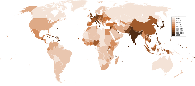
चित्र:Countries by population density.svg

Size of this PNG preview of this SVG file: ८०० × ३५३ पिक्सल. अरु संकल्पहरू: ३२० × १४१ पिक्सल • ६४० × २८२ पिक्सल • १,०२४ × ४५२ पिक्सल • १,२८० × ५६५ पिक्सल • २,५६० × १,१२९ पिक्सल • ६,००० × २,६४७ पिक्सल।
मूल फाइल (SVG फाइल,साधारण ६,००० × २,६४७ पिक्सेलहरु, फाइल आकार: १.६२ मेगाबाइटहरू)
फाइल इतिहास
मिति/समय मा क्लिक गरेर त्यससमयमा यो फाइल कस्तो थियो भनेर हेर्न सकिन्छ ।
| मिति/समय | छोटो चित्र | आकारहरू | प्रयोगकर्ता | टिप्पणी | |
|---|---|---|---|---|---|
| हालको | ०५:१८, २२ डिसेम्बर २०११ |  | ६,०००×२,६४७ (१.६२ मेगाबाइटहरू) | Quibik | added transparency |
| १९:२८, २० फेब्रुअरी २०११ |  | ६,०००×२,६४७ (१.६२ मेगाबाइटहरू) | Erik del Toro Streb | typographically corrected | |
| ०८:०७, ७ जनवरी २००८ |  | ६,०००×२,६४७ (१.६२ मेगाबाइटहरू) | Briefplan~commonswiki | {{Information |Description=A map of the world, with colours to highlight the population density of each country or territory. Numbers on the legend are in people per km<sup>2</sup>, and all countries smaller than 20,000 km<sup>2</sup> are represented by a |
फाइल प्रयोग
यस फाइलमा निम्न 3 पृष्ठहरू जोडिन्छन्:
विश्वव्यापी फाइल प्रयोग
निम्न अन्य विकिहरूमा यस फाइलको प्रयोग:
- af.wikipedia.org मा उपयोग
- ar.wikipedia.org मा उपयोग
- arz.wikipedia.org मा उपयोग
- ast.wikipedia.org मा उपयोग
- av.wikipedia.org मा उपयोग
- awa.wikipedia.org मा उपयोग
- azb.wikipedia.org मा उपयोग
- az.wikipedia.org मा उपयोग
- ba.wikipedia.org मा उपयोग
- be.wikipedia.org मा उपयोग
- bg.wikipedia.org मा उपयोग
- bs.wikipedia.org मा उपयोग
- ca.wikipedia.org मा उपयोग
- ckb.wikipedia.org मा उपयोग
- cs.wikipedia.org मा उपयोग
- cy.wikipedia.org मा उपयोग
- de.wikipedia.org मा उपयोग
- de.wikiversity.org मा उपयोग
- diq.wikipedia.org मा उपयोग
- dsb.wikipedia.org मा उपयोग
- en.wikipedia.org मा उपयोग
- eo.wikipedia.org मा उपयोग
- es.wikipedia.org मा उपयोग
- eu.wikipedia.org मा उपयोग
- fi.wikipedia.org मा उपयोग
- fr.wikipedia.org मा उपयोग
यस फाइलको विश्वव्यापी उपयोगको अधिक जानकारी हेर्नुहोस् ।
