
चित्र:LocationSaoTomeAndPrincipe.png
उच्च रिजोल्युशन अनुपलब्ध
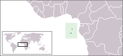
LocationSaoTomeAndPrincipe.png (२५० × ११५ पिक्सेलहरू, फाइल आकार: ७ किलोबाइटहरू, MIME प्रकार: image/png)
| यो विकिमीडिया कमन्सको चित्र हो। त्यहाँ यसको विवरण पृष्ठबाट जानकारी तल देखाइएको छ। कमन्स स्वतन्त्र रूपमा इजाजतपत्र प्राप्त चित्र भण्डार हो। तपाईंले मद्दत गर्न सक्नुहुन्छ। |
Location map for the São Tomé and Príncipe.
Originally created for English Wikipedia by Vardion.
| This work has been released into the public domain by its author, Vardion. This applies worldwide. In some countries this may not be legally possible; if so: |
फाइल इतिहास
मिति/समय मा क्लिक गरेर त्यससमयमा यो फाइल कस्तो थियो भनेर हेर्न सकिन्छ ।
| मिति/समय | छोटो चित्र | आकारहरू | प्रयोगकर्ता | टिप्पणी | |
|---|---|---|---|---|---|
| हालको | ०४:१९, ३१ अगस्ट २०११ | | २५०×११५ (७ किलोबाइटहरू) | Hoshie | added South Sudan |
| ०४:३९, १३ डिसेम्बर २००४ |  | २५०×११५ (६ किलोबाइटहरू) | EugeneZelenko | Location map for the São Tomé and Príncipe.<br/>Originally created for English Wikipedia by Vardion.<br/>{{PD}}<br/>Category:Country locator maps |
फाइल प्रयोग
यो फाइलसँग कुनै पनि पृष्ठ जोडिएको छैन।
विश्वव्यापी फाइल प्रयोग
निम्न अन्य विकिहरूमा यस फाइलको प्रयोग:
- als.wikipedia.org मा उपयोग
- am.wikipedia.org मा उपयोग
- ar.wikipedia.org मा उपयोग
- azb.wikipedia.org मा उपयोग
- ban.wikipedia.org मा उपयोग
- be-tarask.wikipedia.org मा उपयोग
- be.wikipedia.org मा उपयोग
- bg.wikipedia.org मा उपयोग
- bjn.wikipedia.org मा उपयोग
- bo.wikipedia.org मा उपयोग
- br.wikipedia.org मा उपयोग
- bs.wikipedia.org मा उपयोग
- ca.wikipedia.org मा उपयोग
- ckb.wikipedia.org मा उपयोग
- de.wikipedia.org मा उपयोग
- de.wikinews.org मा उपयोग
- de.wikivoyage.org मा उपयोग
- de.wiktionary.org मा उपयोग
- dsb.wikipedia.org मा उपयोग
- en.wikipedia.org मा उपयोग
- User:DanielZM/test
- User:Chris huh/List of African countries
- Portal:Africa/Countries/Selected country
- Portal:Africa/Countries/Selected country/40
- Outline of São Tomé and Príncipe
- List of São Tomé and Príncipe–related topics
- United Nations Security Council Resolution 373
- Portal:São Tomé and Príncipe/Intro
- List of moths of São Tomé and Príncipe
- List of butterflies of São Tomé and Príncipe
- en.wikinews.org मा उपयोग
- en.wikivoyage.org मा उपयोग
- en.wiktionary.org मा उपयोग
- eo.wikipedia.org मा उपयोग
- es.wikipedia.org मा उपयोग
- es.wikinews.org मा उपयोग
- ext.wikipedia.org मा उपयोग
- fa.wikipedia.org मा उपयोग
- fa.wikivoyage.org मा उपयोग
- fiu-vro.wikipedia.org मा उपयोग
- fo.wikipedia.org मा उपयोग
- frp.wikipedia.org मा उपयोग
- fr.wikipedia.org मा उपयोग
यस फाइलको विश्वव्यापी उपयोगको अधिक जानकारी हेर्नुहोस् ।