
चित्र:Seven United Netherlands Janssonius 1658.jpg
यस पूर्व रुपको आकार: ६९५ × ६०० पिक्सल। अरु संकल्पहरू: २७८ × २४० पिक्सल • ५५६ × ४८० पिक्सल • ८९० × ७६८ पिक्सल • १,१८७ × १,०२४ पिक्सल • २,३७४ × २,०४८ पिक्सल • ५,५४३ × ४,७८२ पिक्सल।
मूल फाइल (५,५४३ × ४,७८२ पिक्सेलहरू, फाइल आकार: १४.६३ मेगाबाइटहरू, MIME प्रकार: image/jpeg)
| यो विकिमीडिया कमन्सको चित्र हो। त्यहाँ यसको विवरण पृष्ठबाट जानकारी तल देखाइएको छ। कमन्स स्वतन्त्र रूपमा इजाजतपत्र प्राप्त चित्र भण्डार हो। तपाईंले मद्दत गर्न सक्नुहुन्छ। |
| वर्णन |
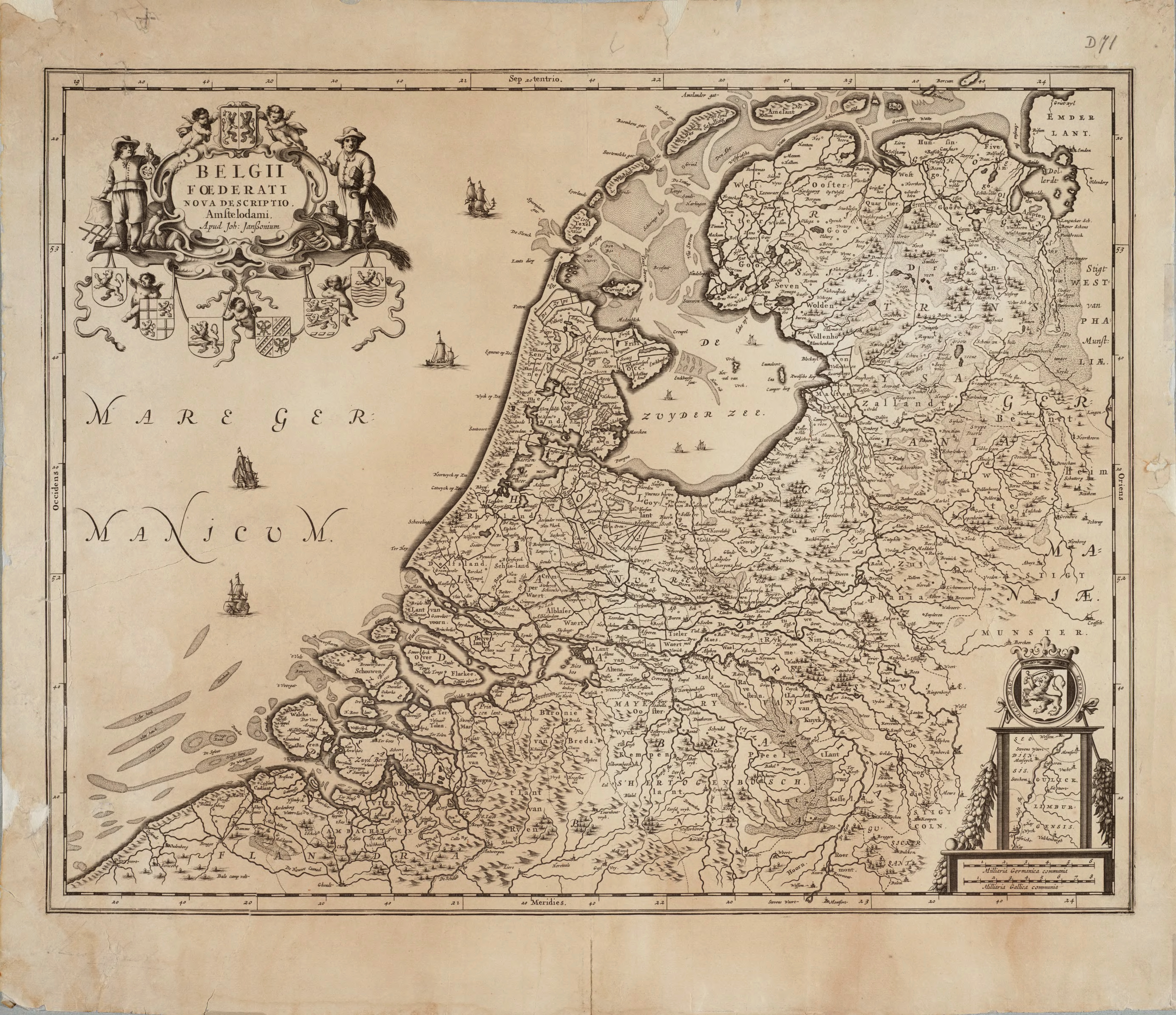
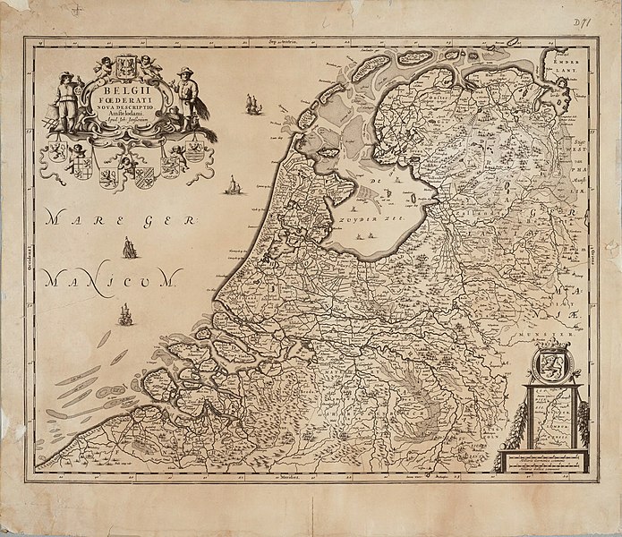
English: Map of the Republic of the Seven United Netherlands Drawn by Joannes (or Johannes) Janssonius, part of his collection Belgii Foederati Nova Descriptio |
|||||||||||||||||||||||||
| मिति | ||||||||||||||||||||||||||
| स्रोत | Archieven.nl Oude versie kwam van:Universiteit van Groningen | |||||||||||||||||||||||||
| लेखक |
|
|||||||||||||||||||||||||
| अनुमति (यो फाइल पुनप्रयोग गर्न) |
|
|||||||||||||||||||||||||
फाइल इतिहास
मिति/समय मा क्लिक गरेर त्यससमयमा यो फाइल कस्तो थियो भनेर हेर्न सकिन्छ ।
| मिति/समय | छोटो चित्र | आकारहरू | प्रयोगकर्ता | टिप्पणी | |
|---|---|---|---|---|---|
| हालको | १७:३७, १६ डिसेम्बर २०१० | | ५,५४३×४,७८२ (१४.६३ मेगाबाइटहरू) | Joopr | De hele kaart met onderste rand, tevens hogere resolutie. |
| ०२:४६, २५ अप्रिल २०१० |  | ३,३४३×२,५३५ (३.९२ मेगाबाइटहरू) | Cropbot | upload cropped version, operated by User:DieBuche. Summary: cropped | |
| १७:३१, ३० जुलाई २००५ |  | ३,४२६×२,५५० (१.२२ मेगाबाइटहरू) | BenTels | Map of the Republic of the Seven United Netherlands<br> Drawn by Joannes (or ''Johannes'') Janssonius<br> Part of his atlas ''Belgii Foederati Nova Descriptio''<br> Published in Amsterdam in 1658 Map predates international copyright law, plus author |
फाइल प्रयोग
यो फाइलसँग कुनै पनि पृष्ठ जोडिएको छैन।
विश्वव्यापी फाइल प्रयोग
निम्न अन्य विकिहरूमा यस फाइलको प्रयोग:
- ar.wikipedia.org मा उपयोग
- bg.wikipedia.org मा उपयोग
- br.wikipedia.org मा उपयोग
- ca.wikipedia.org मा उपयोग
- cs.wikipedia.org मा उपयोग
- cy.wikipedia.org मा उपयोग
- da.wikipedia.org मा उपयोग
- de.wikipedia.org मा उपयोग
- de.wikivoyage.org मा उपयोग
- el.wikipedia.org मा उपयोग
- en.wikipedia.org मा उपयोग
- eo.wikipedia.org मा उपयोग
- es.wikipedia.org मा उपयोग
- et.wikipedia.org मा उपयोग
- eu.wikipedia.org मा उपयोग
- fa.wikipedia.org मा उपयोग
- frr.wikipedia.org मा उपयोग
- fr.wikipedia.org मा उपयोग
- fy.wikipedia.org मा उपयोग
यस फाइलको विश्वव्यापी उपयोगको अधिक जानकारी हेर्नुहोस् ।