
चित्र:Sikkim locator map.svg

Size of this PNG preview of this SVG file: ४२४ × ६०० पिक्सल. अरु संकल्पहरू: १७० × २४० पिक्सल • ३३९ × ४८० पिक्सल • ५४३ × ७६८ पिक्सल • ७२४ × १,०२४ पिक्सल • १,४४८ × २,०४८ पिक्सल • १,५९५ × २,२५६ पिक्सल।
मूल फाइल (SVG फाइल,साधारण १,५९५ × २,२५६ पिक्सेलहरु, फाइल आकार: २४४ किलोबाइटहरू)
| यो विकिमीडिया कमन्सको चित्र हो। त्यहाँ यसको विवरण पृष्ठबाट जानकारी तल देखाइएको छ। कमन्स स्वतन्त्र रूपमा इजाजतपत्र प्राप्त चित्र भण्डार हो। तपाईंले मद्दत गर्न सक्नुहुन्छ। |
| शीर्षक |
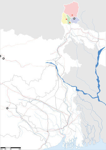
Sikkim locator map |
||
| Description |
Map of w:Sikkim with road and rail lines. Equirectangular projection. Geographic limits of the map: top=28.15, bottom=21.48, left=84.99, right=90.15. |
||
| मिति | |||
| स्रोत |
मेरो आफ्नै कार्य |
||
| रचनाकार |
|
||
| अनुमति (यो फाइल पुनप्रयोग गर्न) |
I, the copyright holder of this work, hereby publish it under the following license: यो फाइल क्रिएटिभ कमन्स एट्रिब्युसन-सेयर एलाइक ३.० अनपोर्टेड लाइसेन्स अनुसारको अनुमति प्राप्त छ।
|
||
| Geotemporal data | |||
| Date depicted | second half of 20 century र 21 century | ||
| Georeferencing | If inappropriate please set warp_status = skip to hide. | ||
| Archival data | |||
| टिप्पणी | Part of WikiProject India Maps | ||
फाइल इतिहास
मिति/समय मा क्लिक गरेर त्यससमयमा यो फाइल कस्तो थियो भनेर हेर्न सकिन्छ ।
| मिति/समय | छोटो चित्र | आकारहरू | प्रयोगकर्ता | टिप्पणी | |
|---|---|---|---|---|---|
| हालको | १५:४३, १२ मे २००७ | | १,५९५×२,२५६ (२४४ किलोबाइटहरू) | Planemad | border fix |
| ०१:०५, ८ मे २००७ |  | १,५९५×२,२५६ (२५२ किलोबाइटहरू) | Planemad | border | |
| ००:५९, ८ मे २००७ |  | १,५९५×२,२५६ (२४५ किलोबाइटहरू) | Planemad | {{WikiProject_India_Maps |Title=Gujarat locator map.svg locator map |Description=Map of w:Gujarat locator map.svg with road and rail lines. |Source= |Date=May 2007 |Author=w:user:Planemad }} Category:WikiProject India State Maps |
फाइल प्रयोग
यो फाइलसँग कुनै पनि पृष्ठ जोडिएको छैन।
विश्वव्यापी फाइल प्रयोग
निम्न अन्य विकिहरूमा यस फाइलको प्रयोग:
- as.wikipedia.org मा उपयोग
- be.wikipedia.org मा उपयोग
- de.wikipedia.org मा उपयोग
- dty.wikipedia.org मा उपयोग
- en.wikipedia.org मा उपयोग
- es.wikipedia.org मा उपयोग
- fa.wikipedia.org मा उपयोग
- gu.wikipedia.org मा उपयोग
- hi.wikipedia.org मा उपयोग
- lv.wikipedia.org मा उपयोग
- mai.wikipedia.org मा उपयोग
- ml.wikipedia.org मा उपयोग
- ms.wikipedia.org मा उपयोग
- or.wikipedia.org मा उपयोग
- pam.wikipedia.org मा उपयोग
- pnb.wikipedia.org मा उपयोग
- sw.wikipedia.org मा उपयोग
- ta.wikipedia.org मा उपयोग
- uk.wikipedia.org मा उपयोग
- vi.wikipedia.org मा उपयोग
- yo.wikipedia.org मा उपयोग