
चित्र:Cities in China.png
यस पूर्व रुपको आकार: ७५९ × ६०० पिक्सल। अरु संकल्पहरू: ३०४ × २४० पिक्सल • ६०७ × ४८० पिक्सल • ९७२ × ७६८ पिक्सल • १,२८० × १,०१२ पिक्सल • २,५६० × २,०२३ पिक्सल • ६,२४६ × ४,९३७ पिक्सल।
मूल फाइल (६,२४६ × ४,९३७ पिक्सेलहरू, फाइल आकार: ८९५ किलोबाइटहरू, MIME प्रकार: image/png)
| यो विकिमीडिया कमन्सको चित्र हो। त्यहाँ यसको विवरण पृष्ठबाट जानकारी तल देखाइएको छ। कमन्स स्वतन्त्र रूपमा इजाजतपत्र प्राप्त चित्र भण्डार हो। तपाईंले मद्दत गर्न सक्नुहुन्छ। |

|
This image is expected to always be the most recent one. Feel free to update it when needed.
|

|
This file may be updated to reflect new information. If you wish to use a specific version of the file without new updates being mirrored, please upload the required version as a separate file. |
सारांश
| वर्णन |
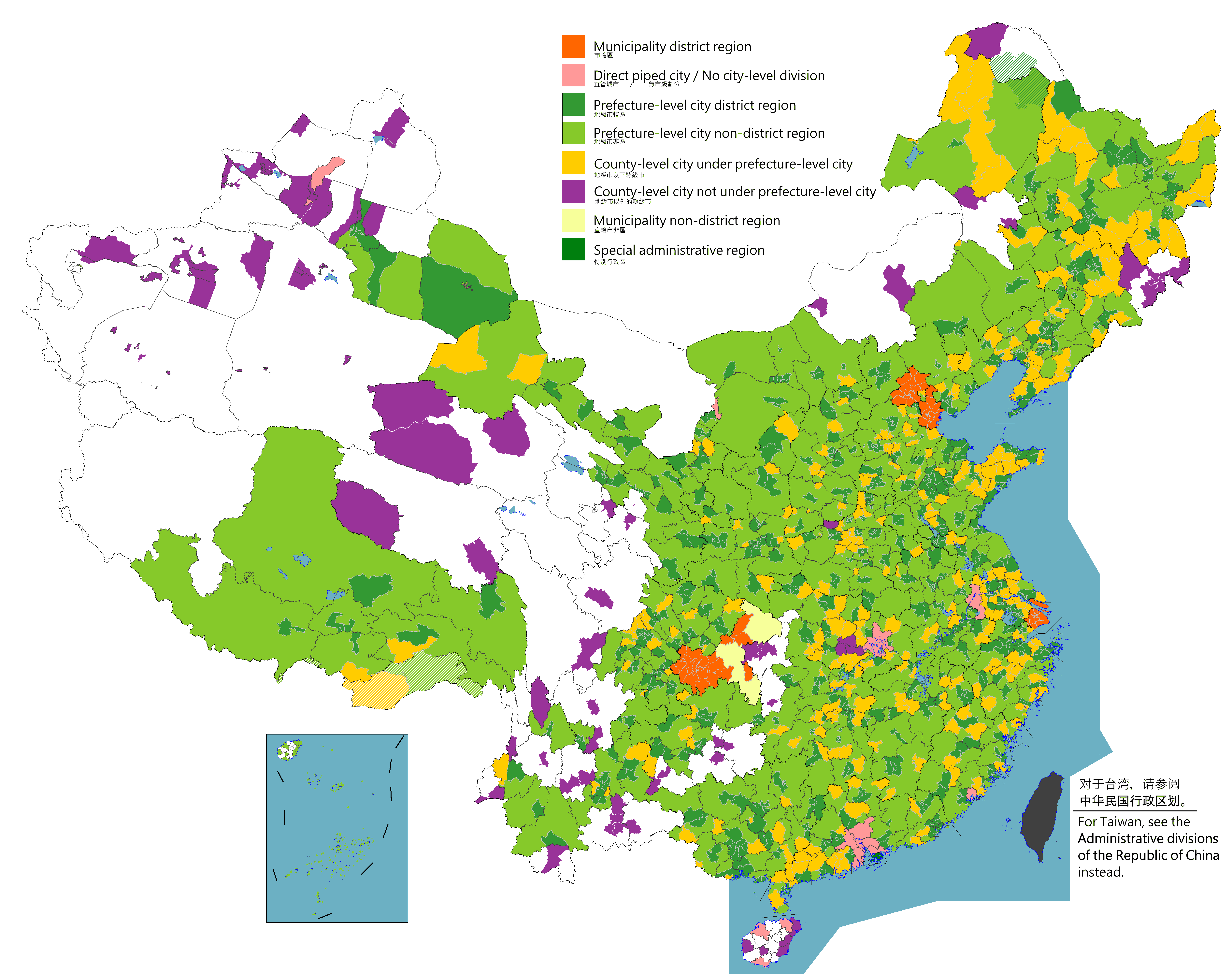
English: Map of China's types of cities.
日本語: 中国の都市の種類の地図。
Русский: Карта типов городов Китая.
Монгол: Хятадын төрлийн хотуудын газрын зураг.
中文(简体):中国城市类型图。(包含未實際控制之疆域)
中文(繁體):中國城市類型圖。 (包含未實際控制之疆域) |
||
| मिति |
|
||
| स्रोत |
Legend: Municipality district region
Direct piped city / No city-level division
Prefecture-level city district region
Prefecture-level city non-district region
County-level city under prefecture-level city
County-level city not prefecture-level city
Municipality non-district region
Special administrative region
Source appearances:
[]
|
||
| लेखक |
|
||
| अनुमति (यो फाइल पुनप्रयोग गर्न) |
Map of China, types of cities: I, the copyright holder of this work, hereby publish it under the following license:
|
.png)
.png)
अनुज्ञा प्राप्त गर्दै
I, the copyright holder of this work, hereby publish it under the following license:
This file is licensed under the Creative Commons Attribution-Share Alike 4.0 International license.
- तपाईं स्वतन्त्र हुनुहुन्छ :
- साझेदारी गर्नुहाेस् – रचनालाई कपी, वितरित तथा संचारित गर्नको लागि
- रिमिक्स गर्नको लागि – काम अनुकूलित गर्नको लागि
- निम्नलिखित कारणहरूको अन्तर्गत:
- एट्रिब्युसन – तपाईंले रचनाको श्रेय अनुमतिपत्रकर्ता अथवा लेखकले बताएको माध्यमले दिनु पर्नेछ (तर यस प्रकार हैन, जसमा लागोस् की उ तपाईंलाई अथवा तपाईंको रचनाको प्रयोगलाई समर्थन गर्छन्)।
- शेयर अलाइक – यदि तपाई यस रचनामा कुनै परिवर्तन अथवा संसोधन गर्नुहुन्छ या यसमा आधारित केही रचना गर्नुहुन्छ भने तपाई निष्कर्ष स्वरूप बनेको रचनालाई मात्र यहाँ अथवा यसको समान कुनै अनिमति पत्र अन्तर्गत वितरित गर्न सक्नुहुन्छ।

|
This locator map image could be re-created using vector graphics as an SVG file. This has several advantages; see Commons:Media for cleanup for more information. If an SVG form of this image is available, please upload it and afterwards replace this template with
{{vector version available|new image name}}.
It is recommended to name the SVG file “Cities in China.svg”—then the template Vector version available (or Vva) does not need the new image name parameter. |
|
|
This map image could be re-created using vector graphics as an SVG file. This has several advantages; see Commons:Media for cleanup for more information. If an SVG form of this image is available, please upload it and afterwards replace this template with
{{vector version available|new image name}}.
It is recommended to name the SVG file “Cities in China.svg”—then the template Vector version available (or Vva) does not need the new image name parameter. |
| Annotations | This image is annotated: View the annotations at Commons |
फाइल इतिहास
मिति/समय मा क्लिक गरेर त्यससमयमा यो फाइल कस्तो थियो भनेर हेर्न सकिन्छ ।
| मिति/समय | छोटो चित्र | आकारहरू | प्रयोगकर्ता | टिप्पणी | |
|---|---|---|---|---|---|
| हालको | १५:५४, २ अगस्ट २०२३ | | ६,२४६×४,९३७ (८९५ किलोबाइटहरू) | Maanshen | |
| १५:४४, २ अगस्ट २०२३ |  | ६,२४६×४,९३७ (८९७ किलोबाइटहरू) | Maanshen | ||
| १५:३६, २ अगस्ट २०२३ |  | ६,२४६×४,९३७ (८९३ किलोबाइटहरू) | Maanshen | ||
| १४:४४, १ अगस्ट २०२३ |  | ६,२४६×४,९३७ (८९१ किलोबाइटहरू) | Maanshen | ||
| ०४:५१, ३ अगस्ट २०२२ |  | ६,२४६×४,९३७ (९०१ किलोबाइटहरू) | Maanshen | Update disputed/claimed borders, white with stroke is not claimed and filled in color is claimed | |
| ०५:५३, २० अप्रिल २०२२ |  | ६,२४६×४,९३७ (८९३ किलोबाइटहरू) | Maanshen | Fix borders between Ili's Kuytun, Huyanghe, and Karamay | |
| ०७:३०, ३१ मार्च २०२२ |  | ६,२४६×४,९३७ (८९३ किलोबाइटहरू) | Maanshen | Fix some colors | |
| ०६:४४, २९ मार्च २०२२ |  | ६,२४६×४,९३७ (८९३ किलोबाइटहरू) | Maanshen | Fix colors in Shanxi with Fenyang and Xiaoyi | |
| ०६:४५, १७ मार्च २०२२ |  | ६,२४६×४,९३७ (८९३ किलोबाइटहरू) | Maanshen | Fix Dongtai as a county-level city | |
| ०९:३६, १ मार्च २०२२ |  | ६,२४६×४,९३७ (८९३ किलोबाइटहरू) | Maanshen | Update Shanghai land reclamation and cpunty border changes as of 2022 |
फाइल प्रयोग
यस फाइलमा निम्न पृष्ठ जोडिन्छ:
विश्वव्यापी फाइल प्रयोग
निम्न अन्य विकिहरूमा यस फाइलको प्रयोग:
- en.wikipedia.org मा उपयोग
- fi.wikipedia.org मा उपयोग
- id.wikipedia.org मा उपयोग
- ilo.wikipedia.org मा उपयोग
- ko.wikipedia.org मा उपयोग
- ku.wikipedia.org मा उपयोग
- mk.wikipedia.org मा उपयोग
- mn.wikipedia.org मा उपयोग
- th.wikipedia.org मा उपयोग
- tr.wikipedia.org मा उपयोग
- uz.wikipedia.org मा उपयोग
- zh.wikipedia.org मा उपयोग