
चित्र:D-angusticeps-range.png

यस पूर्व रुपको आकार: ६३५ × ६०० पिक्सल। अरु संकल्पहरू: २५४ × २४० पिक्सल • ५०८ × ४८० पिक्सल • ८१३ × ७६८ पिक्सल • १,०८४ × १,०२४ पिक्सल • १,५२५ × १,४४० पिक्सल।
मूल फाइल (१,५२५ × १,४४० पिक्सेलहरू, फाइल आकार: ४३२ किलोबाइटहरू, MIME प्रकार: image/png)
| यो विकिमीडिया कमन्सको चित्र हो। त्यहाँ यसको विवरण पृष्ठबाट जानकारी तल देखाइएको छ। कमन्स स्वतन्त्र रूपमा इजाजतपत्र प्राप्त चित्र भण्डार हो। तपाईंले मद्दत गर्न सक्नुहुन्छ। |
सारांश
| वर्णन |
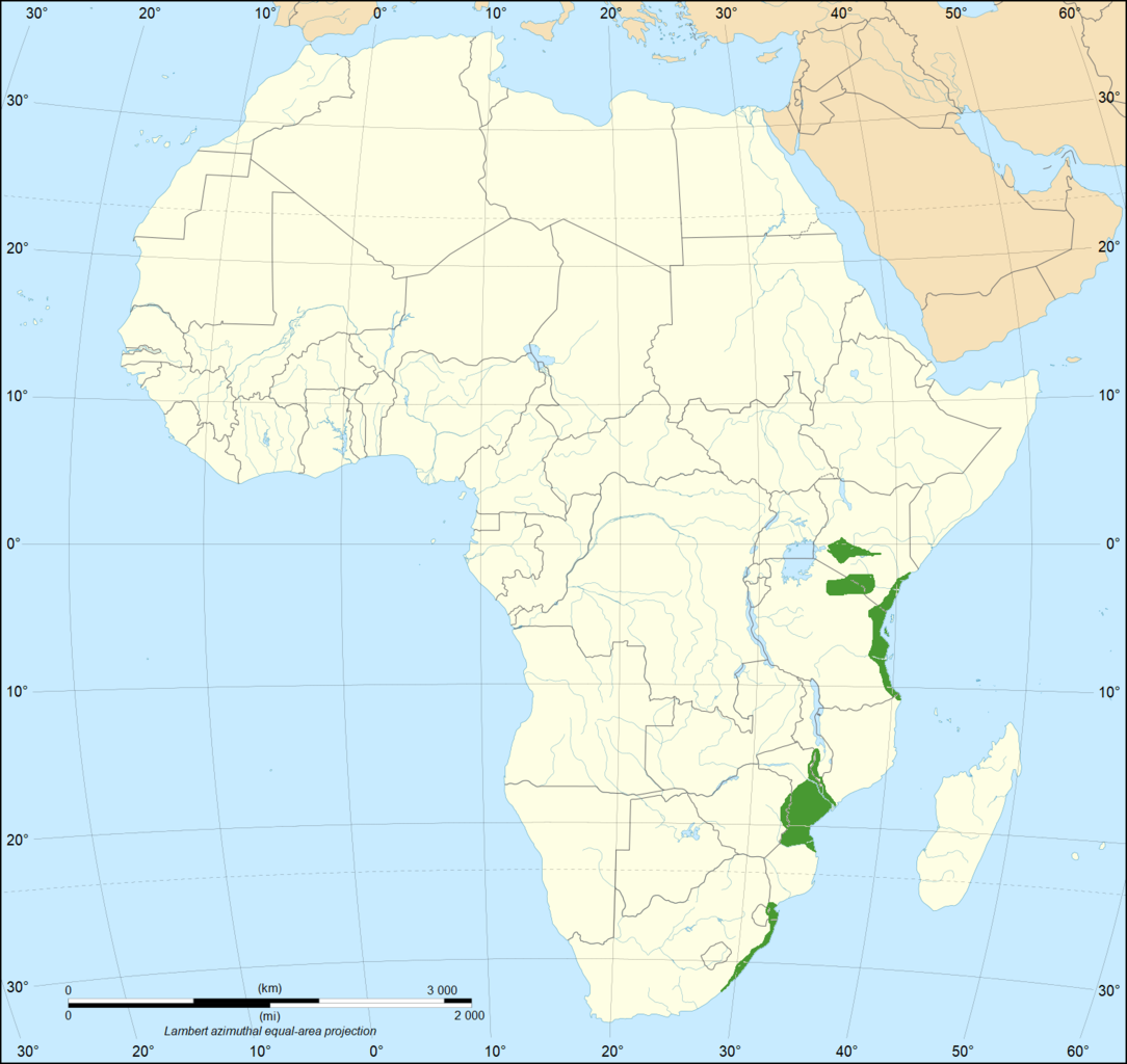
English: The geographical range of the Eastern green mamba in Africa. Data on range is from (2018). "The medical threat of mamba envenoming in sub-Saharan Africa revealed by genus-wide analysis of venom composition, toxicity and antivenomics profiling of available antivenoms". Journal of Proteomics 172: 173–189. DOI:10.1016/j.jprot.2017.08.016. PMID 28843532. Base map is File:Africa map blank.svg |
| मिति | |
| स्रोत | मेरो आफ्नै कार्य |
| लेखक | Casliber |

|
File:Range of the Eastern Green Mamba.svg is a vector version of this file. It should be used in place of this PNG file when not inferior.
File:D-angusticeps-range.png → File:Range of the Eastern Green Mamba.svg
For more information, see Help:SVG. |
 |
अनुज्ञा प्राप्त गर्दै
I, the copyright holder of this work, hereby publish it under the following license:
| This file is made available under the Creative Commons CC0 1.0 Universal Public Domain Dedication. | |
| The person who associated a work with this deed has dedicated the work to the public domain by waiving all of their rights to the work worldwide under copyright law, including all related and neighboring rights, to the extent allowed by law. You can copy, modify, distribute and perform the work, even for commercial purposes, all without asking permission.
|
फाइल इतिहास
मिति/समय मा क्लिक गरेर त्यससमयमा यो फाइल कस्तो थियो भनेर हेर्न सकिन्छ ।
| मिति/समय | छोटो चित्र | आकारहरू | प्रयोगकर्ता | टिप्पणी | |
|---|---|---|---|---|---|
| हालको | १७:१२, १३ अक्टोबर २०१९ | | १,५२५×१,४४० (४३२ किलोबाइटहरू) | Casliber | Now has accurate range map based on https://doi.org/10.1016/j.jprot.2017.08.016. Base map is now File:Africa map blank.svg |
| ०३:१९, २८ मार्च २०१८ |  | ३३३×३६५ (१८ किलोबाइटहरू) | Maphobbyist | Actual range | |
| २२:२४, १८ डिसेम्बर २०११ |  | ४५४×३९८ (१२ किलोबाइटहरू) | Sebastian80~commonswiki |
फाइल प्रयोग
यस फाइलमा निम्न पृष्ठ जोडिन्छ:
विश्वव्यापी फाइल प्रयोग
निम्न अन्य विकिहरूमा यस फाइलको प्रयोग:
- ar.wikipedia.org मा उपयोग
- arz.wikipedia.org मा उपयोग
- bg.wikipedia.org मा उपयोग
- bn.wikipedia.org मा उपयोग
- ceb.wikipedia.org मा उपयोग
- cs.wikipedia.org मा उपयोग
- de.wikipedia.org मा उपयोग
- es.wikipedia.org मा उपयोग
- et.wikipedia.org मा उपयोग
- eu.wikipedia.org मा उपयोग
- fa.wikipedia.org मा उपयोग
- fi.wikipedia.org मा उपयोग
- frr.wikipedia.org मा उपयोग
- he.wikipedia.org मा उपयोग
- hu.wikipedia.org मा उपयोग
- hy.wikipedia.org मा उपयोग
- id.wikipedia.org मा उपयोग
- pl.wikipedia.org मा उपयोग
- pt.wikipedia.org मा उपयोग
- ro.wikipedia.org मा उपयोग
- ru.wikipedia.org मा उपयोग
- sv.wikipedia.org मा उपयोग
- th.wikipedia.org मा उपयोग
- uk.wikipedia.org मा उपयोग
- vi.wikipedia.org मा उपयोग
- www.wikidata.org मा उपयोग