
चित्र:Thames Estuary and Wind Farms from Space NASA.jpg

यस पूर्व रुपको आकार: ७५० × ६०० पिक्सल। अरु संकल्पहरू: ३०० × २४० पिक्सल • ६०० × ४८० पिक्सल • ९६० × ७६८ पिक्सल • १,२८० × १,०२४ पिक्सल • २,५६० × २,०४८ पिक्सल • ५,००० × ४,००० पिक्सल।
मूल फाइल (५,००० × ४,००० पिक्सेलहरू, फाइल आकार: २.३४ मेगाबाइटहरू, MIME प्रकार: image/jpeg)
| यो विकिमीडिया कमन्सको चित्र हो। त्यहाँ यसको विवरण पृष्ठबाट जानकारी तल देखाइएको छ। कमन्स स्वतन्त्र रूपमा इजाजतपत्र प्राप्त चित्र भण्डार हो। तपाईंले मद्दत गर्न सक्नुहुन्छ। |
सारांश
| वर्णन |
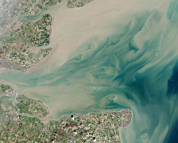
English: Thames Estuary and Wind Farms from Space NASA. Windfarms visible in the image are: London Array, Thanet Wind Farm, Kentish Flats Wind Farm and Gunfleet Sands Wind Farm. |
| मिति | |
| स्रोत | http://earthobservatory.nasa.gov/IOTD/view.php?id=82844 |
| लेखक | Operational Land Imager |
| अरु संस्करणहरू |
 (with annotations) |
| Camera location | | View this and other nearby images on: OpenStreetMap |
|---|
अनुज्ञा प्राप्त गर्दै
| This file is in the public domain in the United States because it was solely created by NASA. NASA copyright policy states that "NASA material is not protected by copyright unless noted". (See Template:PD-USGov, NASA copyright policy page or JPL Image Use Policy.) | ||
 |
Warnings:
|
फाइल इतिहास
मिति/समय मा क्लिक गरेर त्यससमयमा यो फाइल कस्तो थियो भनेर हेर्न सकिन्छ ।
| मिति/समय | छोटो चित्र | आकारहरू | प्रयोगकर्ता | टिप्पणी | |
|---|---|---|---|---|---|
| हालको | ०२:५५, २३ जुन २०१५ | | ५,०००×४,००० (२.३४ मेगाबाइटहरू) | Delusion23 | User created page with UploadWizard |
फाइल प्रयोग
यस फाइलमा निम्न पृष्ठ जोडिन्छ:
विश्वव्यापी फाइल प्रयोग
निम्न अन्य विकिहरूमा यस फाइलको प्रयोग:
- ceb.wikipedia.org मा उपयोग
- cy.wikipedia.org मा उपयोग
- en.wikipedia.org मा उपयोग
- en.wikibooks.org मा उपयोग
- es.wikipedia.org मा उपयोग
- eu.wikipedia.org मा उपयोग
- fa.wikipedia.org मा उपयोग
- ga.wikipedia.org मा उपयोग
- it.wikipedia.org मा उपयोग
- ko.wikipedia.org मा उपयोग
- ru.wikipedia.org मा उपयोग
- sl.wikipedia.org मा उपयोग
- sv.wikipedia.org मा उपयोग
- uk.wikipedia.org मा उपयोग
- www.wikidata.org मा उपयोग
- zh.wikipedia.org मा उपयोग