मिसिसिपी नदी
स्वरूप
एक अनाथ पृष्ठको रुपमा रहेको, अन्य विकिपृष्ठसित नजोडिएको वा एक-दुईवटा लेखहरूसँग मात्र जोडिएको हुनसक्छ। कृपया सम्बन्धित लेखहरूलाई यस पृष्ठ सूत्रसँग जोड्न सहायता गर्नुहोस् |
| मिसिसिपी नदी | |
|---|---|
 | |
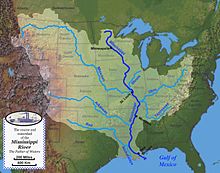
 Map of the course, watershed, and major tributaries of the Mississippi River | |
| नामाकरण | Ojibwe word misi-ziibi, meaning "Great River", or gichi-ziibi, meaning "Big River" |
| स्थान | |
| Country | |
| State | Minnesota |
| भौतिक विषेशताहरू | |
| मुख | |
• स्थान | Pilottown |
• उन्नतांस | ० फिट (० मी) |
| लम्बाइ | २,३२० माइल (३,७३० किमी) |
| निकास | |
| • स्थान | St. Louis |
| जलाधारका विशेषताहरू | |
| सहरहरू | Minneapolis, MN |
मिसिसिपी नदी उत्तर अमेरिकाको सबैभन्दा ठूलो नदि हो ।[४][५]
सन्दर्भ सूची
[सम्पादन गर्नुहोस्]- ↑ Kammerer, J.C. (मे १९९०), "Largest Rivers in the United States", U.S. Geological Survey, अन्तिम पहुँच २०११-०२-२२।
- ↑ Median of the 14,610 daily mean streamflows recorded by the USGS for the period 1967–2006.
- ↑ The United States Geological Survey recognizes two contrasting definitions of a river's source.USGS.gov By the stricter definition, the Mississippi would share its source with its longest tributary, the Missouri, at Brower's Spring in Montana. The other definition acknowledges "somewhat arbitrary decisions" and places the Mississippi's source at Lake Itasca, which is publicly accepted as the source,USGS.gov and which had been identified as such by Brower himself.MT.gov वेब्याक मेसिन अभिलेखिकरण २०१२-०१-१८ मिति
- ↑ United States Geological Survey Hydrological Unit Code: 08-09-01-00- Lower Mississippi-New Orleans Watershed
- ↑ "Lengths of the major rivers", United States Geological Survey, अन्तिम पहुँच २००९-०३-१४।
