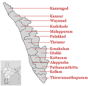
केरलका जिल्लाहरू

| Code[१] | District | Headquarters[२] | Established[३] | Subdivisions | Population २००१ अनुसार[उद्यतन][२] | Area[२] | Population Density |
|---|---|---|---|---|---|---|---|
| AL | Alappuzha | Alappuzha | 7 Aug 1957[४] | 2,105,349 | १,४१४ वर्ग किलोमिटर (५४६ वर्ग माइल) | १,४८९ /km2 (३,८५६/sq mi) | |
| ER | Ernakulam | Kakkanad | 1 Apr 1958[५] | 3,098,378 | २,९५१ वर्ग किलोमिटर (१,१३९ वर्ग माइल) | १,०५० /km2 (२,७१९/sq mi) | |
| ID | Idukki | Painavu | 26 Jan 1972[७][८] |
|
1,128,605 | ४,४७९ वर्ग किलोमिटर (१,७२९ वर्ग माइल) | २५२ /km2 (६५३/sq mi) |
| KL | Kollam | Kollam | 1 Nov 1956[९] ( )[१०] |
2,584,118 | २,४९८ वर्ग किलोमिटर (९६४ वर्ग माइल) | १,०३४ /km2 (२,६७८/sq mi) | |
| KN | Kannur | Kannur | 1 Jan 1957[१२] |
|
2,412,365 | २,९६६ वर्ग किलोमिटर (१,१४५ वर्ग माइल) | ८१३ /km2 (२,१०६/sq mi) |
| KS | Kasaragod | Kasaragod | 24 May 1984[१३][१४] | 1,203,342 | १,९९२ वर्ग किलोमिटर (७६९ वर्ग माइल) | ६०४ /km2 (१,५६४/sq mi) | |
| KT | Kottayam | Kottayam | 1 Nov 1956[१६] ( )[१०] |
1,952,901 | २,२०३ वर्ग किलोमिटर (८५१ वर्ग माइल) | ८८६ /km2 (२,२९५/sq mi) | |
| KZ | Kozhikode | Kozhikode | 1 Jan 1957[१८] | 2,878,498 | २,३४५ वर्ग किलोमिटर (९०५ वर्ग माइल) | १,२२८ /km2 (३,१८१/sq mi) | |
| MA | Malappuram | Malappuram | 16 Jun 1969[२०] |
|
3,629,640 | ३,५५० वर्ग किलोमिटर (१,३७१ वर्ग माइल) | १,०२२ /km2 (२,६४७/sq mi) |
| PL | Palakkad | Palakkad | 1 Jan 1957[२१] |
|
2,617,072 | ४,४८० वर्ग किलोमिटर (१,७३० वर्ग माइल) | ५८४ /km2 (१,५१३/sq mi) |
| PT | Pathanamthitta | Pathanamthitta | 1 Nov 1982[२३][२४] |
|
1,231,577 | २,४६२ वर्ग किलोमिटर (९५१ वर्ग माइल) | ५०० /km2 (१,२९५/sq mi) |
| TS | Thrissur | Thrissur | 1 Nov 1956[२६] (1 Jul 1949)[१०] |
2,975,440 | ३,०३२ वर्ग किलोमिटर (१,१७१ वर्ग माइल) | ९८१ /km2 (२,५४१/sq mi) | |
| TV | Thiruvananthapuram | Thiruvananthapuram | 1 Nov 1956[१०][२७] | 3,234,707 | २,१९२ वर्ग किलोमिटर (८४६ वर्ग माइल) | १,४७६ /km2 (३,८२३/sq mi) | |
| WA | Wayanad | Kalpetta | 1 Nov 1980[२८] |
|
786,627 | २,१३१ वर्ग किलोमिटर (८२३ वर्ग माइल) | ३६९ /km2 (९५६/sq mi) |
| Total | — | — | — | — | 31,841,374 | ३८,८६३ वर्ग किलोमिटर (१५,००५ वर्ग माइल) | ८१९.३२ /km2 (२,१२२/sq mi) |
सन्दर्भ[सम्पादन गर्नुहोस्]
- ↑ "NIC Policy on format of e-mail Address: Appendix (2): Districts Abbreviations as per ISO 3166–2" (PDF), Ministry Of Communications and Information Technology, Government of India, २००४-०८-१८, पृ: 5–10, अन्तिम पहुँच २००८-११-२४।
- ↑ २.० २.१ २.२ "Districts : Kerala", Government of India portal, अन्तिम पहुँच २००९-०३-११।
- ↑ Here 'Established' means year of establishment as a district of Kerala. If the district was formed earlier to the formation of district in the state of Kerala ,1 Nov 1956 will be considered as the day of establishment of the district.
- ↑ ४.० ४.१ "Alappuzha : History", alappuzha.nic.in, अन्तिम पहुँच २००९-०३-११।
- ↑ "History of Ernakulam", ernakulam.nic.in ( Ministry of Communication & Information Technology, Govt. of India), अन्तिम पहुँच २००९-०३-११।
- ↑ "Taluks — Ernakulam District", ernakulam.nic.in, अन्तिम पहुँच २००९-०३-११।
- ↑ "IDUKKI : History", idukki.nic.in ( Ministry of Communication & Information Technology, Govt. of India), अन्तिम पहुँच २००९-०३-११।
- ↑ as per Government notification No 54131/C2/71/RD dated 24 January 1972, Government of Kerala
- ↑ "Short History of Kollam", kollam.nic.in, अन्तिम पहुँच २००९-०३-११।
- ↑ १०.० १०.१ १०.२ १०.३ Note: This date means the day when the district was initially formed , even before the formation of the state of Kerala. Hence 1 Nov 1956 will be considered as the day of formation of district in the state of Kerala
- ↑ उद्दरण त्रुटी: Invalid
<ref>tag; no text was provided for refs namedkollamnictaluk - ↑ १२.० १२.१ "Kannur district : Administration", knr.kerala.gov.in ( Govt. of Kerala), अन्तिम पहुँच २००९-०३-११। वेब्याक मेसिन अभिलेखिकरण २०१९-०१-०७ मिति
- ↑ "DISTRICT CAME INTO EXISTENCE...", kasargod.nic.in, अन्तिम पहुँच २००९-०३-११।
- ↑ As per GO.(MS)No.520/84/RD dated 19.05.1984 , Government of Kerala
- ↑ "Kasaragod District > taluks", kasargod.nic.in, अन्तिम पहुँच २००९-०३-११।
- ↑ "District Handbooks of Kerala KOTTAYAM", kerala.gov.in, अन्तिम पहुँच २००९-०३-११। वेब्याक मेसिन अभिलेखिकरण २००९-०३-१९ मिति
- ↑ "KOTTAYAM : Short History", Kerala.gov.in, अन्तिम पहुँच २००९-०३-१२। वेब्याक मेसिन अभिलेखिकरण २००८-११-२० मिति
- ↑ "kozhikode: History", kozhikode.nic.in, अन्तिम पहुँच २००९-०३-१२।
- ↑ "Kozhikode:Administration", kozhikode.nic.in, अन्तिम पहुँच २००९-०३-१२।
- ↑ २०.० २०.१ "Malappuram: HISTORY", malappuram.nic.in, अन्तिम पहुँच २००९-०३-१२।
- ↑ "Welcome to Palghat", palghat.net, अन्तिम पहुँच २००९-०३-१२।
- ↑ "BASIC STATISTICS of PALAKKAD", palakkad.nic.in, अन्तिम पहुँच २००९-०३-१२।
- ↑ "Pathanamthitta : History", pathanamthitta.nic.in, अन्तिम पहुँच २००९-०३-१२।
- ↑ As per GO (MS) No.1026/82/(RD) dated 29.10.1982, Government of Kerala
- ↑ "Pathanamthitta : Administration", pathanamthitta.nic.in, अन्तिम पहुँच २००९-०३-१२।
- ↑ २६.० २६.१ "Thrissur At A Glance", thrissur.nic.in, अन्तिम पहुँच २००९-०३-१२।
- ↑ २७.० २७.१ "THIRUVANANTHAPURAM", अन्तिम पहुँच २००९-०३-१२। वेब्याक मेसिन अभिलेखिकरण २००९-०२-०७ मिति
- ↑ २८.० २८.१ "Wayanad :profile", wayanad.nic.in, अन्तिम पहुँच २००९-०३-१२।
विकिमिडिया कमन्समा केरलका जिल्लाहरू सम्बन्धी अन्य सामग्रीहरू रहेका छन्।
