
चित्र:Barun Valley - Nghe.jpg

यस पूर्व रुपको आकार: ६३१ × ६०० पिक्सल। अरु संकल्पहरू: २५३ × २४० पिक्सल • ५०५ × ४८० पिक्सल • ८०८ × ७६८ पिक्सल • १,०७७ × १,०२४ पिक्सल • १,९८० × १,८८२ पिक्सल।
मूल फाइल (१,९८० × १,८८२ पिक्सेलहरू, फाइल आकार: २.०१ मेगाबाइटहरू, MIME प्रकार: image/jpeg)
| यो विकिमीडिया कमन्सको चित्र हो। त्यहाँ यसको विवरण पृष्ठबाट जानकारी तल देखाइएको छ। कमन्स स्वतन्त्र रूपमा इजाजतपत्र प्राप्त चित्र भण्डार हो। तपाईंले मद्दत गर्न सक्नुहुन्छ। |
सारांश
| वर्णन |
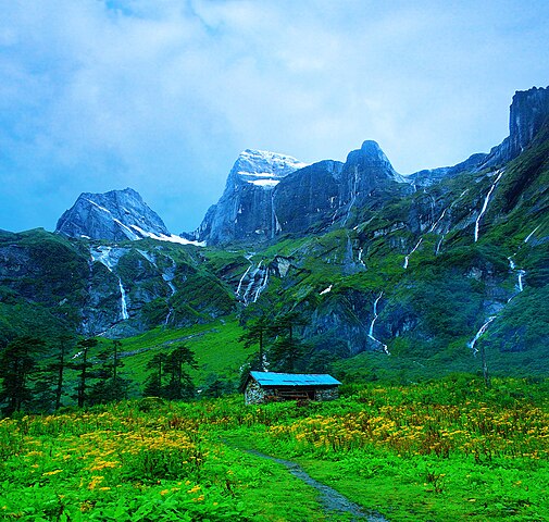
English: Place called Nghe along the Barun Valley. Nghe in local Sherpa language means a 'Sacred Place'. |
| मिति | |
| स्रोत | मेरो आफ्नै कार्य |
| लेखक | Dhilung |
| अरु संस्करणहरू | https://www.flickr.com/photos/dhilung/3904555723/ |
| Camera location | | View this and other nearby images on: OpenStreetMap |
|---|
अनुज्ञा प्राप्त गर्दै
I, the copyright holder of this work, hereby publish it under the following license:
This file is licensed under the Creative Commons Attribution 3.0 Unported license.
- तपाईं स्वतन्त्र हुनुहुन्छ :
- साझेदारी गर्नुहाेस् – रचनालाई कपी, वितरित तथा संचारित गर्नको लागि
- रिमिक्स गर्नको लागि – काम अनुकूलित गर्नको लागि
- निम्नलिखित कारणहरूको अन्तर्गत:
- एट्रिब्युसन – तपाईंले रचनाको श्रेय अनुमतिपत्रकर्ता अथवा लेखकले बताएको माध्यमले दिनु पर्नेछ (तर यस प्रकार हैन, जसमा लागोस् की उ तपाईंलाई अथवा तपाईंको रचनाको प्रयोगलाई समर्थन गर्छन्)।
फाइल इतिहास
मिति/समय मा क्लिक गरेर त्यससमयमा यो फाइल कस्तो थियो भनेर हेर्न सकिन्छ ।
| मिति/समय | छोटो चित्र | आकारहरू | प्रयोगकर्ता | टिप्पणी | |
|---|---|---|---|---|---|
| हालको | ११:५१, २९ जुलाई २०१८ | | १,९८०×१,८८२ (२.०१ मेगाबाइटहरू) | WikiPedant | Reverted to version as of 18:56, 14 December 2009 (UTC). My previous version had splotchiness in the clouds. I may try again to correct saturation, later. |
| ११:३६, २९ जुलाई २०१८ |  | १,९८०×१,८८२ (२.०३ मेगाबाइटहरू) | WikiPedant | Corrected extreme oversaturation. (A great shot!) | |
| ००:४१, १५ डिसेम्बर २००९ |  | १,९८०×१,८८२ (२.०१ मेगाबाइटहरू) | Dhilung | Larger resolution file without watermark. | |
| ०२:५५, १० सेप्टेम्बर २००९ |  | १,१२५×१,००१ (७०६ किलोबाइटहरू) | Dhilung | {{Information |Description={{en|1=Place called Nghe along the Barun Valley. Nghe in local Sherpa language means a 'Sacred Place'.}} |Source=Own work by uploader |Author=Dhilung |Date=2009-08-15 |Permission= |other_versions= }} {{location |
फाइल प्रयोग
यस फाइलमा निम्न 13 पृष्ठहरू जोडिन्छन्:
- नेपालका प्राकृतिक सम्पदाहरूको सूची
- बरुण उपत्यका
- मकालु-बरूण राष्ट्रिय निकुञ्ज
- संरक्षित क्षेत्र
- विकिपिडिया:प्रमुख चित्र/अक्टोबर २०१६
- विकिपिडिया:प्रमुख चित्र/जुलाई २०१५
- विकिपिडिया:प्रमुख चित्र/मार्च २०१४
- ढाँचा:प्रमुख चित्र/अक्टोबर २०१६
- ढाँचा:प्रमुख चित्र/जुलाई २०१५
- ढाँचा:प्रमुख चित्र/मार्च २०१४
- ढाँचा:प्रमुख चित्र/२०१४-०३-२०
- ढाँचा:प्रमुख चित्र/२०१५-०७-०१
- ढाँचा:प्रमुख चित्र/२०१६-१०-२०
विश्वव्यापी फाइल प्रयोग
निम्न अन्य विकिहरूमा यस फाइलको प्रयोग:
- ast.wikipedia.org मा उपयोग
- az.wikipedia.org मा उपयोग
- ban.wikipedia.org मा उपयोग
- bh.wikipedia.org मा उपयोग
- bn.wikipedia.org मा उपयोग
- cs.wikipedia.org मा उपयोग
- da.wikipedia.org मा उपयोग
- de.wikipedia.org मा उपयोग
- dty.wikipedia.org मा उपयोग
- en.wikipedia.org मा उपयोग
- es.wikipedia.org मा उपयोग
- hi.wikipedia.org मा उपयोग
- hu.wikipedia.org मा उपयोग
- hyw.wikipedia.org मा उपयोग
- it.wikipedia.org मा उपयोग
- lt.wikipedia.org मा उपयोग
- mai.wikipedia.org मा उपयोग
- mk.wikipedia.org मा उपयोग
- ml.wikipedia.org मा उपयोग
- nl.wikipedia.org मा उपयोग
- pnb.wikipedia.org मा उपयोग
- pt.wikipedia.org मा उपयोग
- ro.wikipedia.org मा उपयोग
- ru.wikipedia.org मा उपयोग
- sat.wikipedia.org मा उपयोग
- simple.wikipedia.org मा उपयोग
- sv.wikipedia.org मा उपयोग
- ta.wikipedia.org मा उपयोग
यस फाइलको विश्वव्यापी उपयोगको अधिक जानकारी हेर्नुहोस् ।