
चित्र:Calgary street map.png
यस पूर्व रुपको आकार: ४८३ × ६०० पिक्सल। अरु संकल्पहरू: १९३ × २४० पिक्सल • ३८६ × ४८० पिक्सल • ९६० × १,१९२ पिक्सल।
मूल फाइल (९६० × १,१९२ पिक्सेलहरू, फाइल आकार: ८०२ किलोबाइटहरू, MIME प्रकार: image/png)
| यो विकिमीडिया कमन्सको चित्र हो। त्यहाँ यसको विवरण पृष्ठबाट जानकारी तल देखाइएको छ। कमन्स स्वतन्त्र रूपमा इजाजतपत्र प्राप्त चित्र भण्डार हो। तपाईंले मद्दत गर्न सक्नुहुन्छ। |
सारांश
| वर्णन |
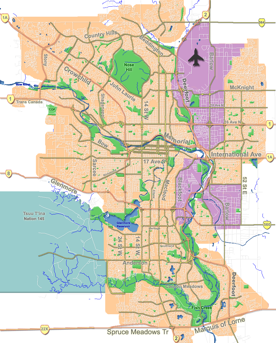
English: Outline map of Calgary. |
| मिति | |
| स्रोत | GIS data |
| लेखक | Qyd |
| अरु संस्करणहरू |
Derivative works of this file: |
| Camera location | | View this and other nearby images on: OpenStreetMap |
|---|
अनुज्ञा प्राप्त गर्दै
| I, the copyright holder of this work, release this work into the public domain. This applies worldwide. In some countries this may not be legally possible; if so: I grant anyone the right to use this work for any purpose, without any conditions, unless such conditions are required by law. |
फाइल इतिहास
मिति/समय मा क्लिक गरेर त्यससमयमा यो फाइल कस्तो थियो भनेर हेर्न सकिन्छ ।
| मिति/समय | छोटो चित्र | आकारहरू | प्रयोगकर्ता | टिप्पणी | |
|---|---|---|---|---|---|
| हालको | ००:१६, ८ अक्टोबर २००७ | | ९६०×१,१९२ (८०२ किलोबाइटहरू) | Qyd | fix highway name |
| ०१:२९, १९ अप्रिल २००७ |  | ९६०×१,१९२ (७९१ किलोबाइटहरू) | Qyd | spelling | |
| २३:१३, १८ सेप्टेम्बर २००६ |  | ९६०×१,१९२ (७९२ किलोबाइटहरू) | Qyd | outline industrial areas | |
| २३:०५, १६ अगस्ट २००६ |  | ९६०×१,१९२ (८०२ किलोबाइटहरू) | Qyd | added airport symbol and highway shields | |
| २१:०६, १४ अगस्ट २००६ |  | ९६०×१,१९२ (७९७ किलोबाइटहरू) | Qyd | fixed interchanges | |
| १०:३१, १४ अगस्ट २००६ |  | ९६०×१,१९२ (७०० किलोबाइटहरू) | Qyd | added city parks | |
| १०:०४, १४ अगस्ट २००६ |  | ९६०×१,१९२ (६४५ किलोबाइटहरू) | Qyd | highways names added | |
| ०६:०२, १४ अगस्ट २००६ |  | ९६०×१,१९२ (४९१ किलोबाइटहरू) | Qyd | {{Information |Description= Outline map of Calgary |Source=GIS data |Date=Aug 2006 |Author=Qyd |Permission=All |other_versions=Image:CalgaryAB-map.png }} Category:Calgary Category:Maps of cities in Canada |
फाइल प्रयोग
यस फाइलमा निम्न 2 पृष्ठहरू जोडिन्छन्:
विश्वव्यापी फाइल प्रयोग
निम्न अन्य विकिहरूमा यस फाइलको प्रयोग:
- ar.wikipedia.org मा उपयोग
- ast.wikipedia.org मा उपयोग
- bh.wikipedia.org मा उपयोग
- bn.wikipedia.org मा उपयोग
- cy.wikipedia.org मा उपयोग
- da.wikipedia.org मा उपयोग
- en.wikipedia.org मा उपयोग
- McMahon Stadium
- Glenmore Reservoir
- Alberta University of the Arts
- Fish Creek Provincial Park
- Heritage Park Historical Village
- Beltline, Calgary
- Nose Hill Park
- Bowness, Calgary
- Kensington, Calgary
- Chinatown, Calgary
- Tsuu T'ina 145
- Inglewood, Calgary
- McKenzie Lake, Calgary
- Eau Claire, Calgary
- Downtown Calgary
- Foothills Medical Centre
- McKenzie Towne, Calgary
- MNP Community & Sport Centre
- List of neighbourhoods in Calgary
- Lakeview, Calgary
- Chinook Centre
- Parkdale, Calgary
- Mission, Calgary
- Marda Loop, Calgary
- Bankview, Calgary
- Mount Royal, Calgary
- Springbank Hill, Calgary
- List of airports in the Calgary area
- Telus Spark Science Centre
- Edgemont, Calgary
- Pineridge, Calgary
- Edworthy Park
- Lake Bonavista, Calgary
- Confederation Park, Calgary
- University Heights, Calgary
- The Military Museums
- Transportation in Calgary
- User:Qyd/Maps
- Market Mall
यस फाइलको विश्वव्यापी उपयोगको अधिक जानकारी हेर्नुहोस् ।