
चित्र:Canada provinces evolution 2.gif

यस पूर्व रुपको आकार: ६९४ × ६०० पिक्सल। अरु संकल्पहरू: २७८ × २४० पिक्सल • ५५६ × ४८० पिक्सल • १,००० × ८६४ पिक्सल।
मूल फाइल (१,००० × ८६४ पिक्सेलहरू, फाइल आकार: २४३ किलोबाइटहरू, MIME प्रकार: image/gif, चकृय गरिएको, २० फ्रेमहरु, १ मिनेट १३ सेकेन्ड)
| यो विकिमीडिया कमन्सको चित्र हो। त्यहाँ यसको विवरण पृष्ठबाट जानकारी तल देखाइएको छ। कमन्स स्वतन्त्र रूपमा इजाजतपत्र प्राप्त चित्र भण्डार हो। तपाईंले मद्दत गर्न सक्नुहुन्छ। |

|
This image could be re-created using vector graphics as an SVG file. This has several advantages; see Commons:Media for cleanup for more information. If an SVG form of this image is available, please upload it and afterwards replace this template with
{{vector version available|new image name}}.
It is recommended to name the SVG file "Canada provinces evolution 2.svg" - then the template Vector version available (or Vva) does not need the new image name parameter. |
|
सारांश
| वर्णन |
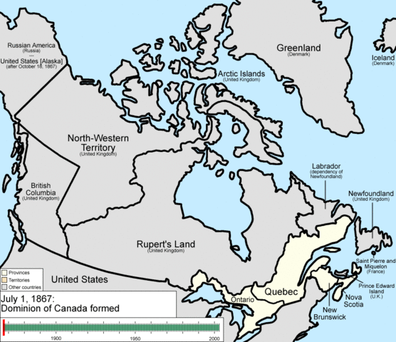
English: Animation of the changes to the borders of Canada.
The captions read as follows:
|
| मिति | |
| स्रोत | मेरो आफ्नै कार्य |
| लेखक | Golbez |
अनुज्ञा प्राप्त गर्दै
I, the copyright holder of this work, hereby publish it under the following licenses:
यो फाइल क्रिएटिभ कमन्स एट्रिब्युसन-सेयर एलाइक ३.० अनपोर्टेड लाइसेन्स अनुसारको अनुमति प्राप्त छ।
- तपाईं स्वतन्त्र हुनुहुन्छ :
- साझेदारी गर्नुहाेस् – रचनालाई कपी, वितरित तथा संचारित गर्नको लागि
- रिमिक्स गर्नको लागि – काम अनुकूलित गर्नको लागि
- निम्नलिखित कारणहरूको अन्तर्गत:
- एट्रिब्युसन – तपाईंले रचनाको श्रेय अनुमतिपत्रकर्ता अथवा लेखकले बताएको माध्यमले दिनु पर्नेछ (तर यस प्रकार हैन, जसमा लागोस् की उ तपाईंलाई अथवा तपाईंको रचनाको प्रयोगलाई समर्थन गर्छन्)।
- शेयर अलाइक – यदि तपाई यस रचनामा कुनै परिवर्तन अथवा संसोधन गर्नुहुन्छ या यसमा आधारित केही रचना गर्नुहुन्छ भने तपाई निष्कर्ष स्वरूप बनेको रचनालाई मात्र यहाँ अथवा यसको समान कुनै अनिमति पत्र अन्तर्गत वितरित गर्न सक्नुहुन्छ।

|
यस दस्तावेजलाई स्वतन्त्र सफ्टवायर फाउन्डेसन द्वारा प्रकाशित जी॰एन॰यू फ्रि डक्यूमेन्टेशन लाइसेन्स को संस्करण 1.2 वा नयाँ (बिना कुनै इन्वेरियेन्ट अनुभाग र पछिल्लो वा पहिलो आवरणका पाठका) को अन्तर्गत कपी, वितरित एवं/अथवा परिवर्तित गर्ने अनुमति प्रदान गरिन्छ । यस लाइसेन्सको एक प्रति जी॰एन॰यू फ्रि डक्यूमेन्टेशन लाइसेन्स नामक अनुभागमा शामिल छ । |
तपाईँ आफ्नो मनपर्ने इजाजतपत्र रोज्न सक्नुहुन्छ ।
फाइल इतिहास
मिति/समय मा क्लिक गरेर त्यससमयमा यो फाइल कस्तो थियो भनेर हेर्न सकिन्छ ।
| मिति/समय | छोटो चित्र | आकारहरू | प्रयोगकर्ता | टिप्पणी | |
|---|---|---|---|---|---|
| हालको | ०४:२२, १५ जुलाई २००९ | | १,०००×८६४ (२४३ किलोबाइटहरू) | Golbez | {{Information |Description=Animation of the changes to the borders of Canada. |Source=self-made |Date=July 15, 2009 |Author= Golbez |Permission= |other_versions= }} Category:Maps of the history of Canada Category:Animated GIF [[Ca |
फाइल प्रयोग
यो फाइलसँग कुनै पनि पृष्ठ जोडिएको छैन।
विश्वव्यापी फाइल प्रयोग
निम्न अन्य विकिहरूमा यस फाइलको प्रयोग:
- ar.wikipedia.org मा उपयोग
- be-tarask.wikipedia.org मा उपयोग
- bg.wikipedia.org मा उपयोग
- ca.wikipedia.org मा उपयोग
- ckb.wikipedia.org मा उपयोग
- cs.wikipedia.org मा उपयोग
- en.wikipedia.org मा उपयोग
- John A. Macdonald
- Manitoba
- Northwest Territories
- Ontario
- History of Canada
- Provinces and territories of Canada
- Talk:Labrador
- List of proposed provinces and territories of Canada
- Quebec Boundaries Extension Act, 1912
- History of Alberta
- Quebec Boundary Extension Act, 1898
- History of Western civilization
- Wikipedia:Featured pictures thumbs/06
- Canada
- Talk:Territorial evolution of Canada
- List of Canada-related topics by provinces and territories
- Demographics of the Northwest Territories
- Speaker of the Legislative Assembly of the Northwest Territories
- Portal:Canada/Selected picture
- Wikipedia:Featured pictures/Diagrams, drawings, and maps/Maps
- Wikipedia:Featured picture candidates/delist/2009
- Wikipedia:Featured picture candidates/delist/Canada provinces evolution.gif
- Talk:History of Canada/Archive 1
- Wikipedia:Featured picture candidates/November-2009
- Wikipedia:Featured picture candidates/Non-Native American Nations Control over N America 1750-2008.gif
- User:North8000
- User:Ezekiel11324/bordercity
- Former colonies and territories in Canada
- User:Soulscanner/Sandbox/CanHist
- Wikipedia:Reference desk/Archives/Miscellaneous/2011 August 15
- User talk:Golbez/Archive 6
- Template:POTD/2015-07-01
- Wikipedia:Picture of the day/July 2015
- Wikipedia:Main Page history/2015 July 1
- User:PMK2000/sandbox/Canada
- Timeline of Alberta history
- en.wikibooks.org मा उपयोग
- es.wikipedia.org मा उपयोग
यस फाइलको विश्वव्यापी उपयोगको अधिक जानकारी हेर्नुहोस् ।