
चित्र:ElectoralCollege2016.svg

मूल फाइल (SVG फाइल,साधारण १,०२० × ५९३ पिक्सेलहरु, फाइल आकार: ३० किलोबाइटहरू)
| यो विकिमीडिया कमन्सको चित्र हो। त्यहाँ यसको विवरण पृष्ठबाट जानकारी तल देखाइएको छ। कमन्स स्वतन्त्र रूपमा इजाजतपत्र प्राप्त चित्र भण्डार हो। तपाईंले मद्दत गर्न सक्नुहुन्छ। |
| U.S. presidential election maps (SVG) |
| See also: National Atlas maps (png) |
|
1789 · 1792 · 1796 · 1800 · 1804 · 1808 · 1812 · 1816 · 1820 · 1824 · 1828 · 1832 · 1836 · 1840 · 1844 · 1848 · 1852 · 1856 · 1860 · 1864 · 1868 · 1872 · 1876 · 1880 · 1884 · 1888 · 1892 · 1896 · 1900 · 1904 · 1908 · 1912 · 1916 · 1920 · 1924 · 1928 · 1932 · 1936 · 1940 · 1944 · 1948 · 1952 · 1956 · 1960 · 1964 · 1968 · 1972 · 1976 · 1980 · 1984 · 1988 · 1992 · 1996 · 2000 · 2004 · 2008 · 2012 · 2016 · 2020 · 2024 |
सारांश
| वर्णन |
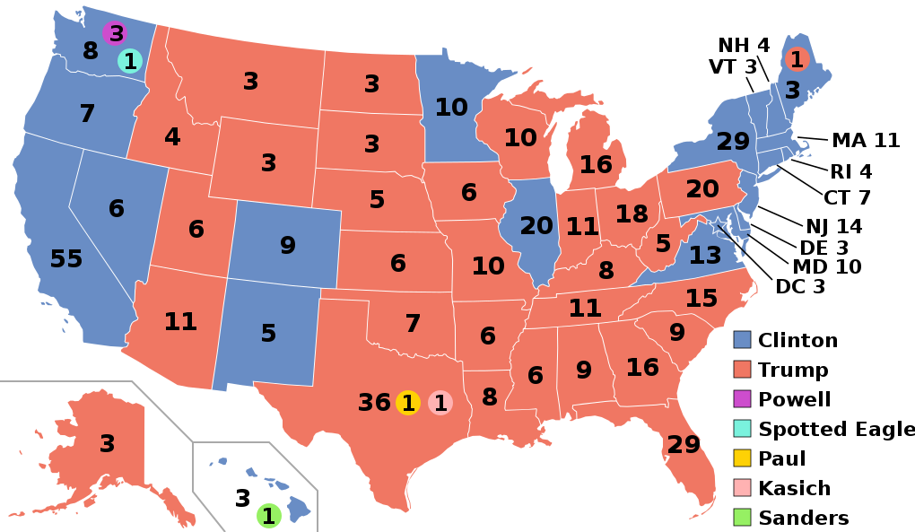
English: Electoral college map for the 2016 United States presidential election (note: Nebraska and Maine split their EVs by congressional district). |
||||
| मिति | |||||
| स्रोत | 2012 Electoral College map | ||||
| लेखक | Gage | ||||
| अरु संस्करणहरू |
|
||||
| SVG genesis |

.svg)


.svg)
.svg)


अनुज्ञा प्राप्त गर्दै
- तपाईं स्वतन्त्र हुनुहुन्छ :
- साझेदारी गर्नुहाेस् – रचनालाई कपी, वितरित तथा संचारित गर्नको लागि
- रिमिक्स गर्नको लागि – काम अनुकूलित गर्नको लागि
- निम्नलिखित कारणहरूको अन्तर्गत:
- एट्रिब्युसन – तपाईंले रचनाको श्रेय अनुमतिपत्रकर्ता अथवा लेखकले बताएको माध्यमले दिनु पर्नेछ (तर यस प्रकार हैन, जसमा लागोस् की उ तपाईंलाई अथवा तपाईंको रचनाको प्रयोगलाई समर्थन गर्छन्)।
- शेयर अलाइक – यदि तपाई यस रचनामा कुनै परिवर्तन अथवा संसोधन गर्नुहुन्छ या यसमा आधारित केही रचना गर्नुहुन्छ भने तपाई निष्कर्ष स्वरूप बनेको रचनालाई मात्र यहाँ अथवा यसको समान कुनै अनिमति पत्र अन्तर्गत वितरित गर्न सक्नुहुन्छ।
फाइल इतिहास
मिति/समय मा क्लिक गरेर त्यससमयमा यो फाइल कस्तो थियो भनेर हेर्न सकिन्छ ।
| मिति/समय | छोटो चित्र | आकारहरू | प्रयोगकर्ता | टिप्पणी | |
|---|---|---|---|---|---|
| हालको | ०९:०७, २७ नोभेम्बर २०२० | | १,०२०×५९३ (३० किलोबाइटहरू) | Politicsfan4 | Updated placement of ME-2's electoral vote for consistency with 2020 map |
| ०७:०७, ५ अगस्ट २०२० |  | १,०२०×५९३ (३० किलोबाइटहरू) | Nojus R | Reverted to version as of 07:42, 13 January 2019 (UTC) it looks so weird when every other map uses a different font | |
| ०१:१६, ११ डिसेम्बर २०१९ |  | १,०२०×५९३ (३० किलोबाइटहरू) | IagoQnsi | switching font to Arial, as it looks less-ugly in the server-side rendering // Editing SVG source code using c:User:Rillke/SVGedit.js | |
| १३:२७, १३ जनवरी २०१९ |  | १,०२०×५९३ (३० किलोबाइटहरू) | Newfraferz87 | (minor) | |
| ०८:३५, २० नोभेम्बर २०१८ |  | १,०२०×५९३ (३० किलोबाइटहरू) | Newfraferz87 | *DC | |
| ०८:२०, २० नोभेम्बर २०१८ |  | १,०२०×५९३ (३० किलोबाइटहरू) | Newfraferz87 | Simplify further: coordinates & fills, following this | |
| २०:०१, १८ जनवरी २०१७ |  | १,०२०×५९३ (३६ किलोबाइटहरू) | Newfraferz87 | Shrink size using relative line coordinates. Thanks for the border corrections. | |
| १५:०५, १७ जनवरी २०१७ |  | १,०२०×५९३ (४३ किलोबाइटहरू) | Karlfk | Better borderlines, esp. OH/WV/PA triangle or ID/MT border | |
| ०८:५९, १२ जनवरी २०१७ |  | १,०२०×५९३ (३६ किलोबाइटहरू) | PalmerTheGolfer | Reverted to version as of 00:56, 3 January 2017 (UTC) Font of numbers and State line consistency with prior elections more important than a non-existent Libretarian faithless elector change | |
| ०४:३५, ११ जनवरी २०१७ |  | १,०२०×५९३ (३६ किलोबाइटहरू) | Maproom | Changed font to Liberation Sans, in the hope of avoiding the problem of "Eagle" extending off the end of the image |
.svg)
फाइल प्रयोग
यस फाइलमा निम्न 2 पृष्ठहरू जोडिन्छन्:
विश्वव्यापी फाइल प्रयोग
निम्न अन्य विकिहरूमा यस फाइलको प्रयोग:
- af.wikipedia.org मा उपयोग
- ang.wikipedia.org मा उपयोग
- ar.wikipedia.org मा उपयोग
- arz.wikipedia.org मा उपयोग
- be.wikipedia.org मा उपयोग
- bg.wikipedia.org मा उपयोग
- bn.wikipedia.org मा उपयोग
- bs.wikipedia.org मा उपयोग
- ca.wikipedia.org मा उपयोग
- cdo.wikipedia.org मा उपयोग
- cs.wikipedia.org मा उपयोग
- cy.wikipedia.org मा उपयोग
- da.wikipedia.org मा उपयोग
- de.wikipedia.org मा उपयोग
- dty.wikipedia.org मा उपयोग
- el.wikipedia.org मा उपयोग
- en.wikipedia.org मा उपयोग
- Donald Trump
- Electoral vote changes between United States presidential elections
- List of United States presidential election results by state
- Presidency of Barack Obama
- 2016 United States presidential election
- United States presidential election
- 2016 Democratic Party presidential candidates
- 2016 Democratic Party presidential primaries
- 2016 Republican Party presidential candidates
- 2016 Republican Party presidential primaries
- Third party and independent candidates for the 2016 United States presidential election
- 2016 United States elections
- User:ArcMachaon/sandbox
- User:Mandruss/sandbox
- User:Visigoethe/sandbox
- User:Machinekng/sandbox
यस फाइलको विश्वव्यापी उपयोगको अधिक जानकारी हेर्नुहोस् ।