
चित्र:Indian Rebellion of 1857.jpg

यस पूर्व रुपको आकार: ७१३ × ५९९ पिक्सल। अरु संकल्पहरू: २८६ × २४० पिक्सल • ५७१ × ४८० पिक्सल • ९१४ × ७६८ पिक्सल • १,२१८ × १,०२४ पिक्सल • १,९५९ × १,६४७ पिक्सल।
मूल फाइल (१,९५९ × १,६४७ पिक्सेलहरू, फाइल आकार: २.८२ मेगाबाइटहरू, MIME प्रकार: image/jpeg)
| यो विकिमीडिया कमन्सको चित्र हो। त्यहाँ यसको विवरण पृष्ठबाट जानकारी तल देखाइएको छ। कमन्स स्वतन्त्र रूपमा इजाजतपत्र प्राप्त चित्र भण्डार हो। तपाईंले मद्दत गर्न सक्नुहुन्छ। |
सारांश
| Description |
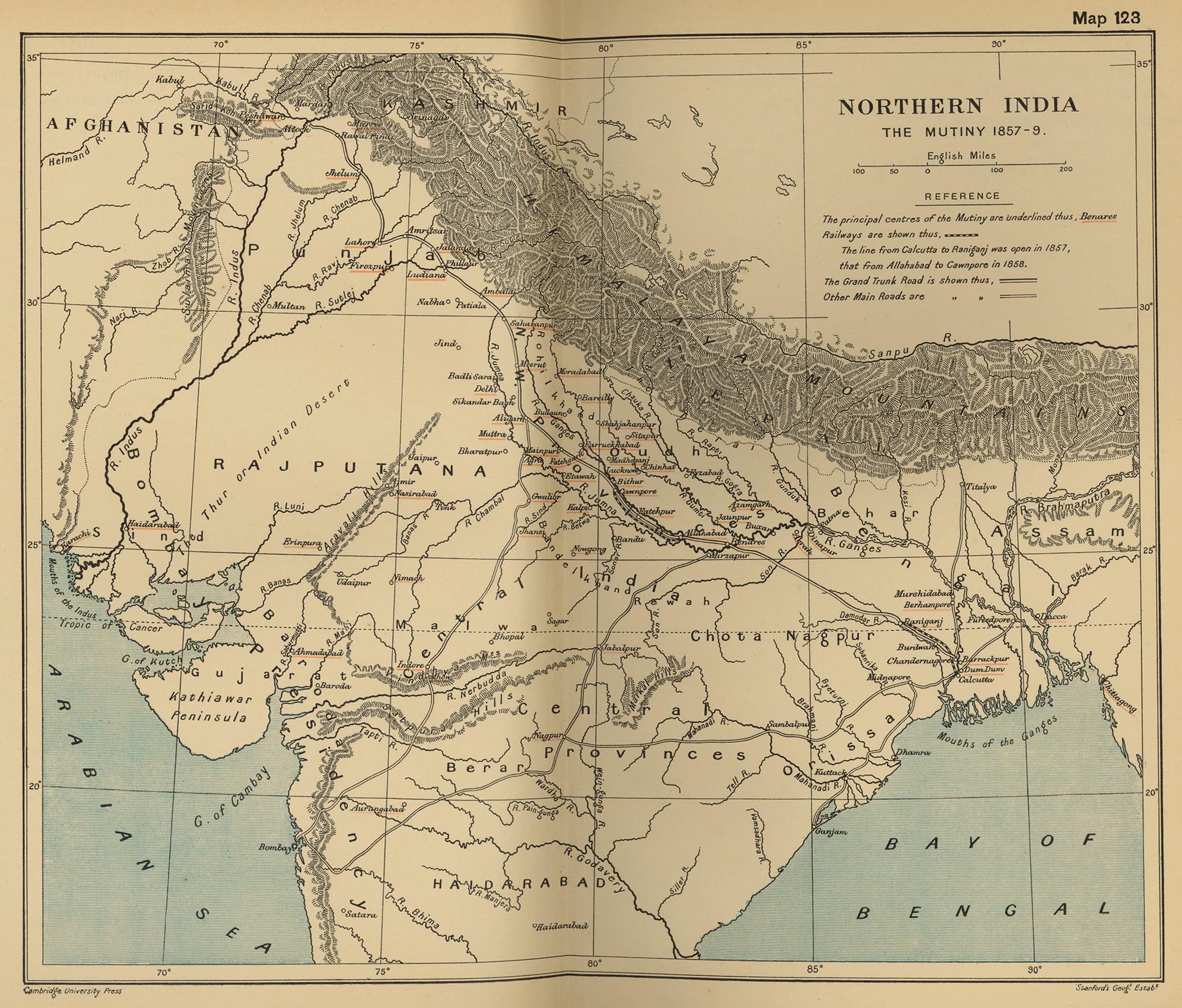
English: Map, "North India: The Mutiny 1857-9" from "The Cambridge Modern History Atlas". Cambridge University Press; London. 1912.
Editors were Sir Adolphus William Ward (†1924), G.W. Prothero (†1922), and Sir Stanley Mordaunt Leathes (†1938). Individual authors of works making up the atlas are not identified, nor are the likely to be, after reasonable research. Español: Mapa del norte de India |
|||||||||
| मिति | ||||||||||
| स्रोत | Perry-Castañeda Library Map Collection Website. | |||||||||
| रचनाकार |
Unknown author Cambridge University Press; Stanford's Geogl. Estabt.. |
|||||||||
| Geotemporal data | ||||||||||
| Bounding box |
|
|||||||||
| Georeferencing | ||||||||||
| अरु संस्करणहरू |
|
|||||||||

अनुज्ञा प्राप्त गर्दै
|
This is a faithful photographic reproduction of a two-dimensional, public domain work of art. The work of art itself is in the public domain for the following reason:
The official position taken by the Wikimedia Foundation is that "faithful reproductions of two-dimensional public domain works of art are public domain".
This photographic reproduction is therefore also considered to be in the public domain in the United States. In other jurisdictions, re-use of this content may be restricted; see Reuse of PD-Art photographs for details. | ||||
Original upload log
The original description page was on en.wikipedia (file log). All following user names refer to en.wikipedia.
- 2010-06-06 08:35 PawełMM 1959×1647× (1118753 bytes) vertical strip shadorws removed
- 2010-06-05 12:13 PawełMM 1959×1647× (1201791 bytes) central verticaly part flattened, cropped
- 2008-03-05 02:51 Fowler&fowler 1992×1700× (683065 bytes) Map, "North India: The Mutiny 1857-9" from "The Cambridge Modern History Atlas" edited by Sir Adolphus William Ward, G.W. Prothero, Sir Stanley Mordaunt Leathes, and E.A. Benians. Cambridge University Press; London. 1912. Downloaded by ~~~~ from the [h
- 2008-03-05 02:37 Fowler&fowler 1992×1700× (715404 bytes) Map, "North India: The Mutiny 1857-9" from "The Cambridge Modern History Atlas" edited by Sir Adolphus William Ward, G.W. Prothero, Sir Stanley Mordaunt Leathes, and E.A. Benians. Cambridge University Press; London. 1912. Downloaded by ~~~~ from the [h
फाइल इतिहास
मिति/समय मा क्लिक गरेर त्यससमयमा यो फाइल कस्तो थियो भनेर हेर्न सकिन्छ ।
| मिति/समय | छोटो चित्र | आकारहरू | प्रयोगकर्ता | टिप्पणी | |
|---|---|---|---|---|---|
| हालको | २१:२०, ११ सेप्टेम्बर २०१२ | | १,९५९×१,६४७ (२.८२ मेगाबाइटहरू) | Yann | color balance, contrast, color corrections |
| १३:३०, १८ अक्टोबर २०१० |  | १,९५९×१,६४७ (१.०७ मेगाबाइटहरू) | File Upload Bot (Magnus Manske) | {{BotMoveToCommons|en.wikipedia|year={{subst:CURRENTYEAR}}|month={{subst:CURRENTMONTHNAME}}|day={{subst:CURRENTDAY}}}} {{Information |Description={{en|Map, "North India: The Mutiny 1857-9" from "The Cambridge Modern History Atlas" edited by Sir Adolphus |
फाइल प्रयोग
यस फाइलमा निम्न पृष्ठ जोडिन्छ:
विश्वव्यापी फाइल प्रयोग
निम्न अन्य विकिहरूमा यस फाइलको प्रयोग:
- ar.wikipedia.org मा उपयोग
- ast.wikipedia.org मा उपयोग
- azb.wikipedia.org मा उपयोग
- bg.wikipedia.org मा उपयोग
- bh.wikipedia.org मा उपयोग
- bn.wikipedia.org मा उपयोग
- br.wikipedia.org मा उपयोग
- cs.wikipedia.org मा उपयोग
- cy.wikipedia.org मा उपयोग
- en.wikipedia.org मा उपयोग
- es.wikipedia.org मा उपयोग
- fr.wikipedia.org मा उपयोग
- hi.wikipedia.org मा उपयोग
- id.wikipedia.org मा उपयोग
- io.wikipedia.org मा उपयोग
- ja.wikipedia.org मा उपयोग
- ka.wikipedia.org मा उपयोग
- lv.wikipedia.org मा उपयोग
- mai.wikipedia.org मा उपयोग
- mr.wikipedia.org मा उपयोग
- ms.wikipedia.org मा उपयोग
- or.wikipedia.org मा उपयोग
- pa.wikipedia.org मा उपयोग
- pl.wikipedia.org मा उपयोग
- pnb.wikipedia.org मा उपयोग
- ru.wikipedia.org मा उपयोग
- sd.wikipedia.org मा उपयोग
- simple.wikipedia.org मा उपयोग
- sr.wikipedia.org मा उपयोग
- sv.wikipedia.org मा उपयोग
- ta.wikipedia.org मा उपयोग
- te.wikipedia.org मा उपयोग
- th.wikipedia.org मा उपयोग
- tr.wikipedia.org मा उपयोग
- ur.wikipedia.org मा उपयोग
यस फाइलको विश्वव्यापी उपयोगको अधिक जानकारी हेर्नुहोस् ।