
चित्र:Kuk New Guinea 2002.jpg

यस पूर्व रुपको आकार: ७५८ × ६०० पिक्सल। अरु संकल्पहरू: ३०३ × २४० पिक्सल • ६०७ × ४८० पिक्सल • ९७१ × ७६८ पिक्सल • १,२८० × १,०१३ पिक्सल • २,५६० × २,०२६ पिक्सल • २,६६४ × २,१०८ पिक्सल।
मूल फाइल (२,६६४ × २,१०८ पिक्सेलहरू, फाइल आकार: १.२७ मेगाबाइटहरू, MIME प्रकार: image/jpeg)
| यो विकिमीडिया कमन्सको चित्र हो। त्यहाँ यसको विवरण पृष्ठबाट जानकारी तल देखाइएको छ। कमन्स स्वतन्त्र रूपमा इजाजतपत्र प्राप्त चित्र भण्डार हो। तपाईंले मद्दत गर्न सक्नुहुन्छ। |
सारांश
| वर्णन |
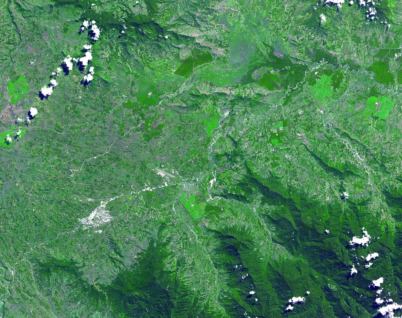
English: The Kuk Early Agricultural Site consists of 116 ha of swamps in the western highlands of New Guinea 1,500 meters above sea-level. Archaeological excavation has revealed the landscape to be one of wetland reclamation worked almost continuously for 7,000, and possibly for 10,000 years. The area was declared a UNESCO World Heritage Site in 2008. The image was acquired May 7, 2002, covers an area of 31.6 x 40 km, and is located at 5.8° S, 144.3° E. |
| मिति | |
| स्रोत | http://photojournal.jpl.nasa.gov/catalog/PIA13090 |
| लेखक | NASA: JPL |
अनुज्ञा प्राप्त गर्दै
| This file is in the public domain in the United States because it was solely created by NASA. NASA copyright policy states that "NASA material is not protected by copyright unless noted". (See Template:PD-USGov, NASA copyright policy page or JPL Image Use Policy.) | ||
 |
Warnings:
|
फाइल इतिहास
मिति/समय मा क्लिक गरेर त्यससमयमा यो फाइल कस्तो थियो भनेर हेर्न सकिन्छ ।
| मिति/समय | छोटो चित्र | आकारहरू | प्रयोगकर्ता | टिप्पणी | |
|---|---|---|---|---|---|
| हालको | ०८:३९, २० मे २०१० | | २,६६४×२,१०८ (१.२७ मेगाबाइटहरू) | Elekhh | {{Information |Description={{en|1=The Kuk Early Agricultural Site consists of 116 ha of swamps in the western highlands of New Guinea 1,500 meters above sea-level. Archaeological excavation has revealed the landsca |
फाइल प्रयोग
यस फाइलमा निम्न पृष्ठ जोडिन्छ:
विश्वव्यापी फाइल प्रयोग
निम्न अन्य विकिहरूमा यस फाइलको प्रयोग:
- af.wikipedia.org मा उपयोग
- ar.wikipedia.org मा उपयोग
- ast.wikipedia.org मा उपयोग
- be.wikipedia.org मा उपयोग
- ca.wikipedia.org मा उपयोग
- cs.wikipedia.org मा उपयोग
- de.wikipedia.org मा उपयोग
- de.wikivoyage.org मा उपयोग
- en.wikipedia.org मा उपयोग
- es.wikipedia.org मा उपयोग
- fa.wikipedia.org मा उपयोग
- fr.wikipedia.org मा उपयोग
- fr.wikivoyage.org मा उपयोग
- gl.wikipedia.org मा उपयोग
- he.wikipedia.org मा उपयोग
- he.wikivoyage.org मा उपयोग
- hr.wikipedia.org मा उपयोग
- hy.wikipedia.org मा उपयोग
- id.wikipedia.org मा उपयोग
- it.wikipedia.org मा उपयोग
- it.wikivoyage.org मा उपयोग
- ja.wikipedia.org मा उपयोग
- ka.wikipedia.org मा उपयोग
- kk.wikipedia.org मा उपयोग
- la.wikipedia.org मा उपयोग
- lt.wikipedia.org मा उपयोग
- lv.wikipedia.org मा उपयोग
यस फाइलको विश्वव्यापी उपयोगको अधिक जानकारी हेर्नुहोस् ।