
चित्र:Map of Izu Islands.png

यस पूर्व रुपको आकार: ५३५ × ६०० पिक्सल। अरु संकल्पहरू: २१४ × २४० पिक्सल • ४२८ × ४८० पिक्सल • ६८५ × ७६८ पिक्सल • १,२५७ × १,४०९ पिक्सल।
मूल फाइल (१,२५७ × १,४०९ पिक्सेलहरू, फाइल आकार: ६९१ किलोबाइटहरू, MIME प्रकार: image/png)
| यो विकिमीडिया कमन्सको चित्र हो। त्यहाँ यसको विवरण पृष्ठबाट जानकारी तल देखाइएको छ। कमन्स स्वतन्त्र रूपमा इजाजतपत्र प्राप्त चित्र भण्डार हो। तपाईंले मद्दत गर्न सक्नुहुन्छ। |
सारांश
| वर्णन |
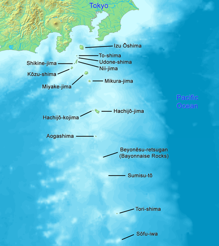
English: High quality map of the Izu Islands. This is the English (Romaji) version with Japanese names. Created with DEMIS World Map Server.
日本語: 日本語:高品質の地図、伊豆諸島。 |
| मिति | |
| स्रोत | मेरो आफ्नै कार्य |
| लेखक | Artanisen |
| अरु संस्करणहरू |
|

अनुज्ञा प्राप्त गर्दै
This image is in the public domain because it came from the site https://www.demis.nl/products/web-map-server/examples/ and was released by the copyright holder. Permission is granted to copy, distribute and/or modify this map since it is based on free of copyright images from: www.demis.nl. See also approval email on de.wp and its clarification.
|
| This work has been released into the public domain by its copyright holder, www.demis.nl. This applies worldwide. In some countries this may not be legally possible; if so: www.demis.nl grants anyone the right to use this work for any purpose, without any conditions, unless such conditions are required by law.
|

|
This map image could be re-created using vector graphics as an SVG file. This has several advantages; see Commons:Media for cleanup for more information. If an SVG form of this image is available, please upload it and afterwards replace this template with
{{vector version available|new image name}}.
It is recommended to name the SVG file “Map of Izu Islands.svg”—then the template Vector version available (or Vva) does not need the new image name parameter. |
फाइल इतिहास
मिति/समय मा क्लिक गरेर त्यससमयमा यो फाइल कस्तो थियो भनेर हेर्न सकिन्छ ।
| मिति/समय | छोटो चित्र | आकारहरू | प्रयोगकर्ता | टिप्पणी | |
|---|---|---|---|---|---|
| हालको | ०६:४९, २४ डिसेम्बर २०२१ | | १,२५७×१,४०९ (६९१ किलोबाइटहरू) | Artanisen | Reverted to version as of 10:15, 2 October 2019 (UTC) reverted to names in English only, because there is a separate Japanese map |
| १३:०७, २१ अक्टोबर २०१९ |  | १,२५७×१,४०९ (७७१ किलोबाइटहरू) | Artanisen | Added Japanese kanji of the island names and thinner black lines. | |
| १६:००, २ अक्टोबर २०१९ |  | १,२५७×१,४०९ (६९१ किलोबाइटहरू) | Artanisen | English: High quality map of the Izu Islands. Created with DEMIS World Map Server. 日本語:高品質の地図、伊豆諸島。 | |
| २०:३६, ५ अक्टोबर २००६ |  | ३००×४०० (३२ किलोबाइटहरू) | Tdk~commonswiki | Map of Izu Islands. Created with DEMIS World Map Server.{{demis-pd}} |
फाइल प्रयोग
यो फाइलसँग कुनै पनि पृष्ठ जोडिएको छैन।
विश्वव्यापी फाइल प्रयोग
निम्न अन्य विकिहरूमा यस फाइलको प्रयोग:
- ar.wikipedia.org मा उपयोग
- az.wikipedia.org मा उपयोग
- bn.wikipedia.org मा उपयोग
- ca.wikipedia.org मा उपयोग
- ceb.wikipedia.org मा उपयोग
- ckb.wikipedia.org मा उपयोग
- cs.wikipedia.org मा उपयोग
- da.wikipedia.org मा उपयोग
- el.wikipedia.org मा उपयोग
- en.wikipedia.org मा उपयोग
- Geography of Japan
- Tokyo
- List of islands of Japan
- Devil's Sea
- Izu Islands
- Nii-jima
- Kōzu-shima
- Portal:Japan
- Shikine-jima
- Izu Ōshima
- Mikura-jima
- Lot's Wife (crag)
- Aogashima
- Tori-shima (Izu Islands)
- Hachijō-kojima
- Smith Island (Japan)
- Inamba-jima
- Udone-shima
- Ōnohara Islands
- Bayonnaise Rocks
- Hachijō language
- Jinai-tō
- List of governors of the Nanpō Islands
- Seven Islands of Izu
- en.wikibooks.org मा उपयोग
- en.wikivoyage.org मा उपयोग
- eo.wikipedia.org मा उपयोग
- es.wikipedia.org मा उपयोग
यस फाइलको विश्वव्यापी उपयोगको अधिक जानकारी हेर्नुहोस् ।