
चित्र:Map of areas affected by 2021 European floods.svg

Size of this PNG preview of this SVG file: ५८७ × ६०० पिक्सल. अरु संकल्पहरू: २३५ × २४० पिक्सल • ४७० × ४८० पिक्सल • ७५२ × ७६८ पिक्सल • १,००२ × १,०२४ पिक्सल • २,००४ × २,०४८ पिक्सल • ५९३ × ६०६ पिक्सल।
मूल फाइल (SVG फाइल,साधारण ५९३ × ६०६ पिक्सेलहरु, फाइल आकार: ६९५ किलोबाइटहरू)
| यो विकिमीडिया कमन्सको चित्र हो। त्यहाँ यसको विवरण पृष्ठबाट जानकारी तल देखाइएको छ। कमन्स स्वतन्त्र रूपमा इजाजतपत्र प्राप्त चित्र भण्डार हो। तपाईंले मद्दत गर्न सक्नुहुन्छ। |
सारांश
| वर्णन |
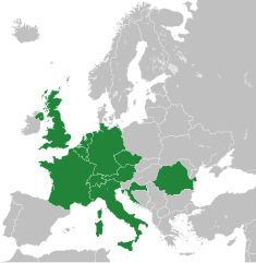
English: A map of the areas affected by the 2021 European Floods, derived from Blank map of Europe cropped.svg.
(Green) 2021 European floods.
(Gray) Europe.
(Light-gray) The surrounding region.
|
| मिति | |
| स्रोत | मेरो आफ्नै कार्य |
| लेखक | Isochrone |
| अरु संस्करणहरू |
This vector image includes elements that have been taken or adapted from this file: |
| SVG genesis |
अनुज्ञा प्राप्त गर्दै
I, the copyright holder of this work, hereby publish it under the following license:
This file is licensed under the Creative Commons Attribution-Share Alike 4.0 International, 3.0 Unported, 2.5 Generic, 2.0 Generic and 1.0 Generic license.
- तपाईं स्वतन्त्र हुनुहुन्छ :
- साझेदारी गर्नुहाेस् – रचनालाई कपी, वितरित तथा संचारित गर्नको लागि
- रिमिक्स गर्नको लागि – काम अनुकूलित गर्नको लागि
- निम्नलिखित कारणहरूको अन्तर्गत:
- एट्रिब्युसन – तपाईंले रचनाको श्रेय अनुमतिपत्रकर्ता अथवा लेखकले बताएको माध्यमले दिनु पर्नेछ (तर यस प्रकार हैन, जसमा लागोस् की उ तपाईंलाई अथवा तपाईंको रचनाको प्रयोगलाई समर्थन गर्छन्)।
- शेयर अलाइक – यदि तपाई यस रचनामा कुनै परिवर्तन अथवा संसोधन गर्नुहुन्छ या यसमा आधारित केही रचना गर्नुहुन्छ भने तपाई निष्कर्ष स्वरूप बनेको रचनालाई मात्र यहाँ अथवा यसको समान कुनै अनिमति पत्र अन्तर्गत वितरित गर्न सक्नुहुन्छ।
फाइल इतिहास
मिति/समय मा क्लिक गरेर त्यससमयमा यो फाइल कस्तो थियो भनेर हेर्न सकिन्छ ।
| मिति/समय | छोटो चित्र | आकारहरू | प्रयोगकर्ता | टिप्पणी | |
|---|---|---|---|---|---|
| हालको | १५:४६, २७ डिसेम्बर २०२२ | | ५९३×६०६ (६९५ किलोबाइटहरू) | Iktsokh | Correction of borders |
| १४:४२, २२ जुलाई २०२१ |  | ५९३×६०६ (६९२ किलोबाइटहरू) | Isochrone | update | |
| १९:५७, १८ जुलाई २०२१ |  | ५९३×६०६ (६९८ किलोबाइटहरू) | GPinkerton | Re-add France because there were also floods in France ([https://en.wikipedia.org/w/index.php?title=2021_European_floods&oldid=1034207380#France]). A more useful map would be by regions, there's no reason Sardinia, most of Great Britain, Northern Ireland, etc need to be here ... | |
| १५:२९, १८ जुलाई २०२१ |  | ५९३×६०६ (६९२ किलोबाइटहरू) | Jurryaany | Added Austria | |
| ००:१३, १८ जुलाई २०२१ |  | ५९३×६०६ (६९२ किलोबाइटहरू) | Isochrone | rm france | |
| १९:३२, १७ जुलाई २०२१ |  | ५९३×६०६ (६९२ किलोबाइटहरू) | Isochrone | better colour | |
| १९:२५, १७ जुलाई २०२१ |  | ५९३×६०६ (६९२ किलोबाइटहरू) | Isochrone | Uploaded own work with UploadWizard |
फाइल प्रयोग
यस फाइलमा निम्न पृष्ठ जोडिन्छ:
विश्वव्यापी फाइल प्रयोग
निम्न अन्य विकिहरूमा यस फाइलको प्रयोग:
- fr.wikipedia.org मा उपयोग
- ja.wikipedia.org मा उपयोग
- pl.wikipedia.org मा उपयोग
- pt.wikipedia.org मा उपयोग
- ro.wikipedia.org मा उपयोग
- simple.wikipedia.org मा उपयोग
- tr.wikipedia.org मा उपयोग