
चित्र:Mount Everest - Hillary and Norgay route - map-fr.svg

Size of this PNG preview of this SVG file: ८०० × ५८८ पिक्सल. अरु संकल्पहरू: ३२० × २३५ पिक्सल • ६४० × ४७० पिक्सल • १,०२४ × ७५३ पिक्सल • १,२८० × ९४१ पिक्सल • २,५६० × १,८८२ पिक्सल • १,००० × ७३५ पिक्सल।
मूल फाइल (SVG फाइल,साधारण १,००० × ७३५ पिक्सेलहरु, फाइल आकार: १.०३ मेगाबाइटहरू)
| यो विकिमीडिया कमन्सको चित्र हो। त्यहाँ यसको विवरण पृष्ठबाट जानकारी तल देखाइएको छ। कमन्स स्वतन्त्र रूपमा इजाजतपत्र प्राप्त चित्र भण्डार हो। तपाईंले मद्दत गर्न सक्नुहुन्छ। |
सारांश
| वर्णन |
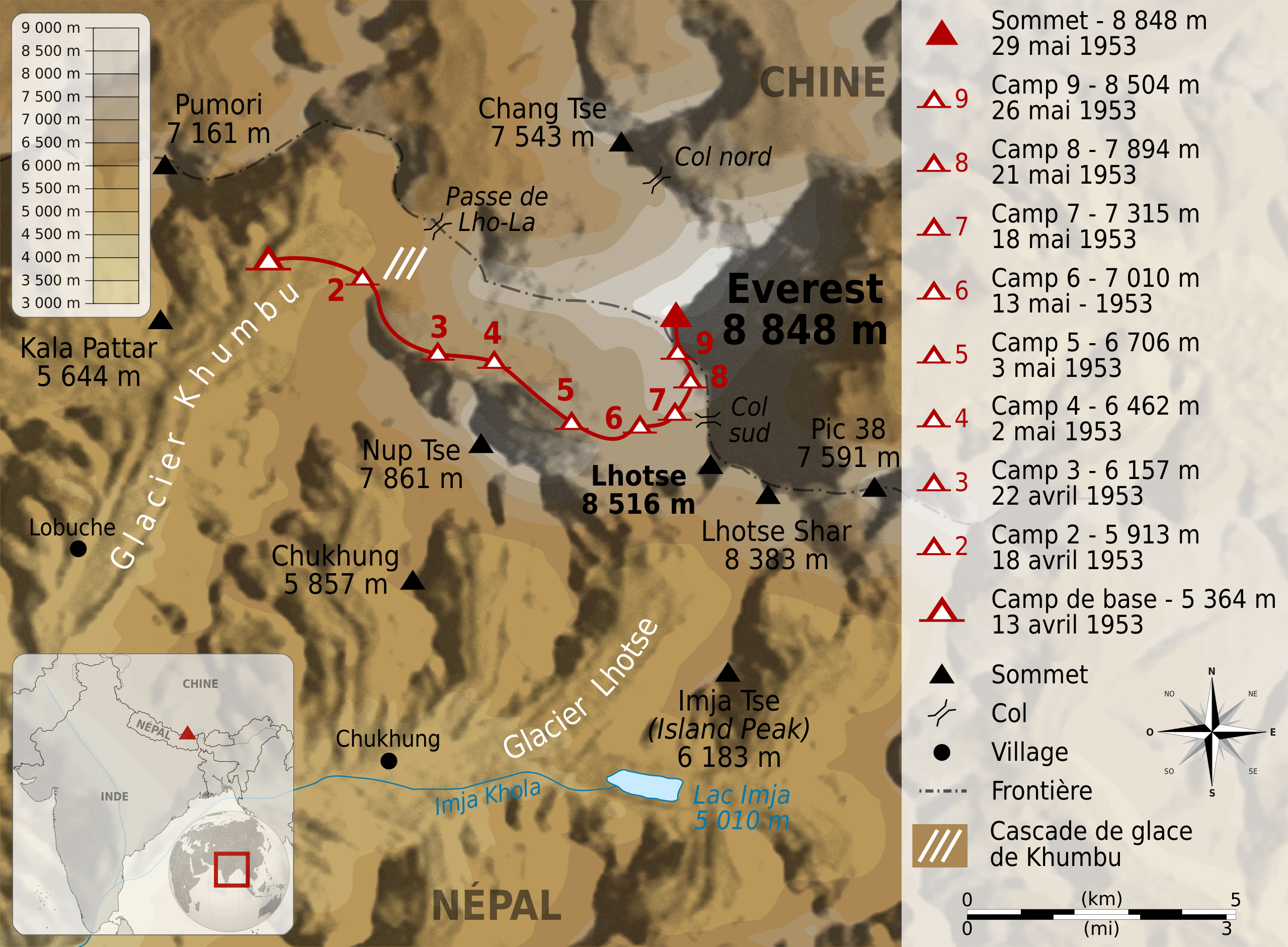
Deutsch: Karte der Route der Erstbesteigung des Mount Everest durch Edmund Hillary und Tenzing Norgay. English: Map of the route followed by Edmund Hillary and Tenzing Norgay during their climbing of Mount Everest, between 13 april 1953 and 29 may 1953. Français : Carte de l'itinéraire suivi par Edmund Hillary etTenzing Norgay lors de leur ascension de l'Everest, entre le 13 avril et le 29 mai 1953. |
||
| मिति | |||
| स्रोत |
|
||
| लेखक | Sémhur | ||
| अरु संस्करणहरू | |||
| एट्रिब्युसन (required by the license) | © Sémhur / Wikimedia Commons / | ||
| SVG | W3C-validity not checked.
|
||
| Graphic Lab |

| Object location | | View this and other nearby images on: OpenStreetMap |
|---|
अनुज्ञा प्राप्त गर्दै
I, the copyright holder of this work, hereby publish it under the following licenses:
| Copyleft: This work of art is free; you can redistribute it and/or modify it according to terms of the Free Art License. You will find a specimen of this license on the Copyleft Attitude site as well as on other sites. |
This file is licensed under the Creative Commons Attribution-Share Alike 4.0 International, 3.0 Unported, 2.5 Generic, 2.0 Generic and 1.0 Generic license.
- तपाईं स्वतन्त्र हुनुहुन्छ :
- साझेदारी गर्नुहाेस् – रचनालाई कपी, वितरित तथा संचारित गर्नको लागि
- रिमिक्स गर्नको लागि – काम अनुकूलित गर्नको लागि
- निम्नलिखित कारणहरूको अन्तर्गत:
- एट्रिब्युसन – तपाईंले रचनाको श्रेय अनुमतिपत्रकर्ता अथवा लेखकले बताएको माध्यमले दिनु पर्नेछ (तर यस प्रकार हैन, जसमा लागोस् की उ तपाईंलाई अथवा तपाईंको रचनाको प्रयोगलाई समर्थन गर्छन्)।
- शेयर अलाइक – यदि तपाई यस रचनामा कुनै परिवर्तन अथवा संसोधन गर्नुहुन्छ या यसमा आधारित केही रचना गर्नुहुन्छ भने तपाई निष्कर्ष स्वरूप बनेको रचनालाई मात्र यहाँ अथवा यसको समान कुनै अनिमति पत्र अन्तर्गत वितरित गर्न सक्नुहुन्छ।
तपाईँ आफ्नो मनपर्ने इजाजतपत्र रोज्न सक्नुहुन्छ ।
फाइल इतिहास
मिति/समय मा क्लिक गरेर त्यससमयमा यो फाइल कस्तो थियो भनेर हेर्न सकिन्छ ।
| मिति/समय | छोटो चित्र | आकारहरू | प्रयोगकर्ता | टिप्पणी | |
|---|---|---|---|---|---|
| हालको | १७:४८, २९ जुन २००९ | | १,०००×७३५ (१.०३ मेगाबाइटहरू) | Sémhur | {{Information |Description={{en|1=Map of the route followed by Edmund Hillary and Tenzing Norgay during their climbing of Mount Everest, between 13 april 1953 and 29 may 1953. }} {{fr|1=C |
फाइल प्रयोग
यो फाइलसँग कुनै पनि पृष्ठ जोडिएको छैन।
विश्वव्यापी फाइल प्रयोग
निम्न अन्य विकिहरूमा यस फाइलको प्रयोग:
- bs.wikipedia.org मा उपयोग
- fr.wikipedia.org मा उपयोग
- mai.wikipedia.org मा उपयोग
- sh.wikipedia.org मा उपयोग