
चित्र:Regions and Prefectures of Japan 2.svg

Size of this PNG preview of this SVG file: ४५२ × ५९९ पिक्सल. अरु संकल्पहरू: १८१ × २४० पिक्सल • ३६२ × ४८० पिक्सल • ५८० × ७६८ पिक्सल • ७७३ × १,०२४ पिक्सल • १,५४६ × २,०४८ पिक्सल • ५७० × ७५५ पिक्सल।
मूल फाइल (SVG फाइल,साधारण ५७० × ७५५ पिक्सेलहरु, फाइल आकार: ३२४ किलोबाइटहरू)
| यो विकिमीडिया कमन्सको चित्र हो। त्यहाँ यसको विवरण पृष्ठबाट जानकारी तल देखाइएको छ। कमन्स स्वतन्त्र रूपमा इजाजतपत्र प्राप्त चित्र भण्डार हो। तपाईंले मद्दत गर्न सक्नुहुन्छ। |
सारांश
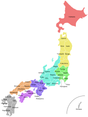
| वर्णन |
English: Map of the regions and prefectures of Japan with Titles.
日本語: 地方別に色を塗り分け、都道府県名とそれらの境を示した日本地図 |
| मिति | |
| स्रोत | मेरो आफ्नै कार्य |
| लेखक | Tokyoship |
| अरु संस्करणहरू |
[]
|


.svg)
.svg)
.svg)
.svg)


.svg)


.png)

.png)
.svg)

.svg)


अनुज्ञा प्राप्त गर्दै
| I, the copyright holder of this work, release this work into the public domain. This applies worldwide. In some countries this may not be legally possible; if so: I grant anyone the right to use this work for any purpose, without any conditions, unless such conditions are required by law. |
फाइल इतिहास
मिति/समय मा क्लिक गरेर त्यससमयमा यो फाइल कस्तो थियो भनेर हेर्न सकिन्छ ।
| मिति/समय | छोटो चित्र | आकारहरू | प्रयोगकर्ता | टिप्पणी | |
|---|---|---|---|---|---|
| हालको | २२:३९, २ जुलाई २०११ | | ५७०×७५५ (३२४ किलोबाइटहरू) | Tokyoship | outline font |
| २२:३३, २ जुलाई २०११ |  | ५७०×७५५ (७७ किलोबाइटहरू) | Tokyoship |
फाइल प्रयोग
यस फाइलमा निम्न 2 पृष्ठहरू जोडिन्छन्:
विश्वव्यापी फाइल प्रयोग
निम्न अन्य विकिहरूमा यस फाइलको प्रयोग:
- af.wikipedia.org मा उपयोग
- as.wikipedia.org मा उपयोग
- ban.wikipedia.org मा उपयोग
- be-tarask.wikipedia.org मा उपयोग
- bh.wikipedia.org मा उपयोग
- blk.wikipedia.org मा उपयोग
- br.wikipedia.org मा उपयोग
- bs.wikipedia.org मा उपयोग
- ca.wikipedia.org मा उपयोग
- cs.wikipedia.org मा उपयोग
- de.wikipedia.org मा उपयोग
- dty.wikipedia.org मा उपयोग
- en.wikipedia.org मा उपयोग
- Japan
- Prefectures of Japan
- Ekiden
- Administrative divisions of Japan
- Template:Japan Regions and Prefectures Labelled Map
- List of capitals in Japan
- List of Japanese prefectural name etymologies
- User:Chickstarr404/Gather lists/13386 – "A Travelers Alphabet" by Stephen Runciman
- 1998 Winter Olympics torch relay
- en.wikibooks.org मा उपयोग
- es.wikipedia.org मा उपयोग
- es.wikiversity.org मा उपयोग
- eu.wikipedia.org मा उपयोग
- hi.wikipedia.org मा उपयोग
- hi.wiktionary.org मा उपयोग
- hu.wikipedia.org मा उपयोग
- hu.wiktionary.org मा उपयोग
- hy.wikipedia.org मा उपयोग
- id.wikipedia.org मा उपयोग
- ilo.wikipedia.org मा उपयोग
- incubator.wikimedia.org मा उपयोग
- it.wikipedia.org मा उपयोग
- jv.wikipedia.org मा उपयोग
- kk.wikipedia.org मा उपयोग
यस फाइलको विश्वव्यापी उपयोगको अधिक जानकारी हेर्नुहोस् ।