
चित्र:The British Empire1.png

यस पूर्व रुपको आकार: ८०० × ४०६ पिक्सल। अरु संकल्पहरू: ३२० × १६२ पिक्सल • ६४० × ३२५ पिक्सल • १,०२४ × ५२० पिक्सल • १,२८० × ६५० पिक्सल • २,७५४ × १,३९८ पिक्सल।
मूल फाइल (२,७५४ × १,३९८ पिक्सेलहरू, फाइल आकार: १४५ किलोबाइटहरू, MIME प्रकार: image/png)
| यो विकिमीडिया कमन्सको चित्र हो। त्यहाँ यसको विवरण पृष्ठबाट जानकारी तल देखाइएको छ। कमन्स स्वतन्त्र रूपमा इजाजतपत्र प्राप्त चित्र भण्डार हो। तपाईंले मद्दत गर्न सक्नुहुन्छ। |
सारांश
| वर्णन |
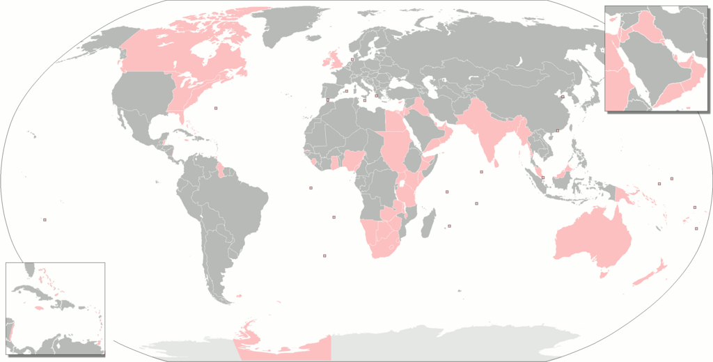
Deutsch: Gebiete, die zur einen oder anderen Zeit Teil des britischen Weltreiches waren.
English: The territories that were at one time or another part of the British Empire.
Français : Territoires ayant fait partie de l'Empire britanique.
Русский: Территории, когда-либо бывшие частью Британской империи.
Українська: Території, які колись були частиною Британської імперії. |
| मिति | |
| स्रोत | मेरो आफ्नै कार्य |
| लेखक | Gd21091993 |
| अरु संस्करणहरू |
The British Empire.png The British Empire (including Crown Dependencies, Crown Colonies-Overseas Territories, Protectorates, Military Administrations).png Map of British India.png British Empire Map (Chinese).svg The British Empire Anachronous.png forked on enwiki |
.png)
.svg)
अनुज्ञा प्राप्त गर्दै
| I, the copyright holder of this work, release this work into the public domain. This applies worldwide. In some countries this may not be legally possible; if so: I grant anyone the right to use this work for any purpose, without any conditions, unless such conditions are required by law. |
फाइल इतिहास
मिति/समय मा क्लिक गरेर त्यससमयमा यो फाइल कस्तो थियो भनेर हेर्न सकिन्छ ।
| मिति/समय | छोटो चित्र | आकारहरू | प्रयोगकर्ता | टिप्पणी | |
|---|---|---|---|---|---|
| हालको | ०५:३३, ८ नोभेम्बर २०२१ | | २,७५४×१,३९८ (१४५ किलोबाइटहरू) | Randomastwritter | somali galbeed |
| ०६:३६, ३१ अक्टोबर २०२१ |  | २,७५४×१,३९८ (१४४ किलोबाइटहरू) | Randomastwritter | juba | |
| ०६:३४, ३१ अक्टोबर २०२१ |  | २,७५४×१,४०० (५२६ किलोबाइटहरू) | Randomastwritter | jubaland | |
| ०५:०५, ४ फेब्रुअरी २०१८ |  | २,७५४×१,३९८ (१४४ किलोबाइटहरू) | Maphobbyist | Upload | |
| १६:२७, २७ जनवरी २०१८ |  | २,७५४×१,३९८ (१४४ किलोबाइटहरू) | Maphobbyist | Added Weihei, Heligoland, the Mosquito Coast, Afghanistan which were under some form of British rule. Colored Chatham Islands of New Zealand and the southeastern islands of Papua New Guinea in pink. | |
| १३:३०, १६ फेब्रुअरी २०१३ |  | २,७५३×१,४०० (६५ किलोबाइटहरू) | JohnnyMrNinja | remove unused alpha, indexed colors and increased compression | |
| ०१:३५, ३ मे २०१० |  | २,७५३×१,४०० (४७७ किलोबाइटहरू) | Gd21091993 | {{Information |Description={{fr|1=Toute les possessions qui on un jour fait partie de l'empire britanique}} |Source={{own}} |Author=Gd21091993 |Date=02/05/2010 |Permission= |other_versions= }} |
फाइल प्रयोग
यस फाइलमा निम्न पृष्ठ जोडिन्छ:
विश्वव्यापी फाइल प्रयोग
निम्न अन्य विकिहरूमा यस फाइलको प्रयोग:
- an.wikipedia.org मा उपयोग
- br.wikipedia.org मा उपयोग
- bs.wikipedia.org मा उपयोग
- da.wikipedia.org मा उपयोग
- eo.wikipedia.org मा उपयोग
- es.wikipedia.org मा उपयोग
- eu.wikipedia.org मा उपयोग
- fa.wikipedia.org मा उपयोग
- fr.wikipedia.org मा उपयोग
- gl.wikipedia.org मा उपयोग
- hak.wikipedia.org मा उपयोग
- hif.wikipedia.org मा उपयोग
- hr.wikipedia.org मा उपयोग
- hu.wikipedia.org मा उपयोग
- hu.wiktionary.org मा उपयोग
- is.wikipedia.org मा उपयोग
- it.wikipedia.org मा उपयोग
- nl.wikipedia.org मा उपयोग
- ro.wikipedia.org मा उपयोग
- ru.wiktionary.org मा उपयोग
- sah.wikipedia.org मा उपयोग
- sh.wikipedia.org मा उपयोग
- xh.wikipedia.org मा उपयोग