
चित्र:Caatinga IBAMA.jpg

यस पूर्व रुपको आकार: ५९६ × ६०० पिक्सल। अरु संकल्पहरू: २३८ × २४० पिक्सल • ४७७ × ४८० पिक्सल • ७६३ × ७६८ पिक्सल • १,०१७ × १,०२४ पिक्सल • २,०३५ × २,०४८ पिक्सल • ३,०४० × ३,०६० पिक्सल।
मूल फाइल (३,०४० × ३,०६० पिक्सेलहरू, फाइल आकार: १.९८ मेगाबाइटहरू, MIME प्रकार: image/jpeg)
| यो विकिमीडिया कमन्सको चित्र हो। त्यहाँ यसको विवरण पृष्ठबाट जानकारी तल देखाइएको छ। कमन्स स्वतन्त्र रूपमा इजाजतपत्र प्राप्त चित्र भण्डार हो। तपाईंले मद्दत गर्न सक्नुहुन्छ। |
सारांश
| वर्णन |
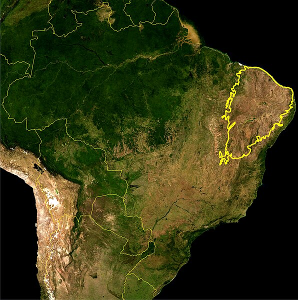
English: This is a map location of the Caatinga Scrub. The yellow line encloses Caatinga scrub as delineated by the IBAMA. I, Miguelrangeljr, made it using NASA Blue Marble imagery and Corel Draw X4 and Photoshop CS5.
Português: Este mapa mostra a localização do bioma da Caatinga. A linha amarela grossa delimita esse bioma como definida pelo IBAMA. Eu,Miguelrangeljr, fiz isso usando uma mapa de satélite da NASA e me baseei no relatório do Desmatamento da Caatinga realizado pelo IBAMA, nos anos de 2002-2008. Para desenhar a linha, foi usado o Corel Draw X4 e o Adobe Photoshop CS5. |
|||||
| मिति | ||||||
| स्रोत | NASA plus my editions by myself | |||||
| लेखक | NASA and Miguelrangeljr | |||||
| अनुमति (यो फाइल पुनप्रयोग गर्न) |
|
अनुज्ञा प्राप्त गर्दै
| This file is in the public domain in the United States because it was solely created by NASA. NASA copyright policy states that "NASA material is not protected by copyright unless noted". (See Template:PD-USGov, NASA copyright policy page or JPL Image Use Policy.) | ||
 |
Warnings:
|
फाइल इतिहास
मिति/समय मा क्लिक गरेर त्यससमयमा यो फाइल कस्तो थियो भनेर हेर्न सकिन्छ ।
| मिति/समय | छोटो चित्र | आकारहरू | प्रयोगकर्ता | टिप्पणी | |
|---|---|---|---|---|---|
| हालको | ०९:००, २५ जुलाई २०१२ | | ३,०४०×३,०६० (१.९८ मेगाबाइटहरू) | Miguelrangeljr | {{Information |Description ={{en|1=This is a map location of the Caatinga Scrub. The yellow line encloses Caatinga scrub as delineated by the IBAMA. I, Miguelrangeljr, made it using NASA Blue Marble imagery and Corel Draw X4 and Photosho... |
फाइल प्रयोग
यस फाइलमा निम्न पृष्ठ जोडिन्छ:
विश्वव्यापी फाइल प्रयोग
निम्न अन्य विकिहरूमा यस फाइलको प्रयोग:
- bg.wikipedia.org मा उपयोग
- es.wikipedia.org मा उपयोग
- et.wikipedia.org मा उपयोग
- gn.wikipedia.org मा उपयोग
- ml.wikipedia.org मा उपयोग
- pt.wikipedia.org मा उपयोग
- ru.wikipedia.org मा उपयोग
- sv.wikipedia.org मा उपयोग
- tt.wikipedia.org मा उपयोग
- uk.wikipedia.org मा उपयोग