
चित्र:ElectoralCollege2004.svg

मूल फाइल (SVG फाइल,साधारण १,०२० × ५९३ पिक्सेलहरु, फाइल आकार: २९ किलोबाइटहरू)
| यो विकिमीडिया कमन्सको चित्र हो। त्यहाँ यसको विवरण पृष्ठबाट जानकारी तल देखाइएको छ। कमन्स स्वतन्त्र रूपमा इजाजतपत्र प्राप्त चित्र भण्डार हो। तपाईंले मद्दत गर्न सक्नुहुन्छ। |
सारांश
| U.S. presidential election maps (SVG) |
| See also: National Atlas maps (png) |
|
1789 · 1792 · 1796 · 1800 · 1804 · 1808 · 1812 · 1816 · 1820 · 1824 · 1828 · 1832 · 1836 · 1840 · 1844 · 1848 · 1852 · 1856 · 1860 · 1864 · 1868 · 1872 · 1876 · 1880 · 1884 · 1888 · 1892 · 1896 · 1900 · 1904 · 1908 · 1912 · 1916 · 1920 · 1924 · 1928 · 1932 · 1936 · 1940 · 1944 · 1948 · 1952 · 1956 · 1960 · 1964 · 1968 · 1972 · 1976 · 1980 · 1984 · 1988 · 1992 · 1996 · 2000 · 2004 · 2008 · 2012 · 2016 · 2020 · 2024 |
| वर्णन |
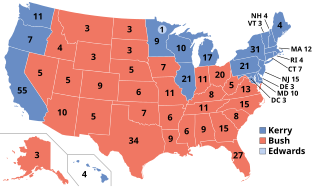
English: Electoral college votes in the 2004 United States Presidential election |
| मिति | |
| स्रोत | मेरो आफ्नै कार्य |
| लेखक | Nkocharh (talk) |
अनुज्ञा प्राप्त गर्दै
| This work has been released into the public domain by its author, Nkocharh at अङ्ग्रेजी विकिपीडिया. This applies worldwide. In some countries this may not be legally possible; if so: Nkocharh grants anyone the right to use this work for any purpose, without any conditions, unless such conditions are required by law. |
Original upload log
Transferred from en.wikipedia to Commons by Furfur using CommonsHelper.
- 2008-03-06 21:49 Nkocharh 1020×593×??? (122642 bytes) Desaturated the colors to match all the other maps to be found here: http://en.wikipedia.org/wiki/United_States_presidential_election_maps
फाइल इतिहास
मिति/समय मा क्लिक गरेर त्यससमयमा यो फाइल कस्तो थियो भनेर हेर्न सकिन्छ ।
| मिति/समय | छोटो चित्र | आकारहरू | प्रयोगकर्ता | टिप्पणी | |
|---|---|---|---|---|---|
| हालको | १४:१०, २२ डिसेम्बर २०१८ | | १,०२०×५९३ (२९ किलोबाइटहरू) | Newfraferz87 | New template |
| १६:४४, ६ फेब्रुअरी २०१७ |  | १,०२०×५९३ (३५ किलोबाइटहरू) | Newfraferz87 | Clearer state borders | |
| ०९:३७, २१ डिसेम्बर २०१६ |  | १,०२०×५९३ (३५ किलोबाइटहरू) | Newfraferz87 | There's no need to make that distinction; there was only one "Bush" running for president that year. | |
| १८:५३, ११ डिसेम्बर २०१६ |  | १,०२०×५९३ (११४ किलोबाइटहरू) | Χ | label G.W. Bush | |
| ०३:४५, ८ नोभेम्बर २०१६ |  | १,०२०×५९३ (१२० किलोबाइटहरू) | Wow | Edwards | |
| ०२:५१, ३ सेप्टेम्बर २००८ |  | १,०२०×५९३ (१२० किलोबाइटहरू) | File Upload Bot (Magnus Manske) | {{BotMoveToCommons|en.wikipedia}} {{Information |Description={{en|Electoral college votes in the 2004 United States Presidential election<br/> en:Category:Maps of the United States en:Category:United States presidential election, 2004 [[:en:Ca |
फाइल प्रयोग
यस फाइलमा निम्न 2 पृष्ठहरू जोडिन्छन्:
विश्वव्यापी फाइल प्रयोग
निम्न अन्य विकिहरूमा यस फाइलको प्रयोग:
- arz.wikipedia.org मा उपयोग
- as.wikipedia.org मा उपयोग
- azb.wikipedia.org मा उपयोग
- bg.wikipedia.org मा उपयोग
- bh.wikipedia.org मा उपयोग
- bs.wikipedia.org मा उपयोग
- cdo.wikipedia.org मा उपयोग
- cy.wikipedia.org मा उपयोग
- dag.wikipedia.org मा उपयोग
- da.wikipedia.org मा उपयोग
- de.wikipedia.org मा उपयोग
- el.wikipedia.org मा उपयोग
- eml.wikipedia.org मा उपयोग
- en.wikipedia.org मा उपयोग
- Presidency of George W. Bush
- 2004 United States presidential election
- 2004 United States presidential election in California
- 2004 United States presidential election in Illinois
- 2004 United States presidential election in Texas
- 2004 United States presidential election in Florida
- 2004 United States presidential election in Pennsylvania
- 2004 United States presidential election in Ohio
- 2004 United States presidential election in Georgia
- 2004 United States presidential election in Iowa
- 2004 United States presidential election in New Jersey
- 2004 United States presidential election in Wisconsin
- 2004 United States presidential election in Alabama
- 2004 United States presidential election in Arizona
- 2004 United States presidential election in Arkansas
- 2004 United States presidential election in Colorado
- 2004 United States presidential election in Delaware
- 2004 United States presidential election in Connecticut
- 2004 United States presidential election in Hawaii
- 2004 United States presidential election in New York
- 2004 United States presidential election in New Hampshire
- 2004 United States presidential election in Vermont
यस फाइलको विश्वव्यापी उपयोगको अधिक जानकारी हेर्नुहोस् ।