चित्र:Qin empire 210 BCE.png

पृष्ठ सामग्री अन्य भाषाहरूमा समर्थित छैन।
यो विकिमीडिया कमन्सको चित्र हो
विकिपिडिया, एक स्वतन्त्र विश्वकोशबाट

Qin_empire_210_BCE.png(५५५ × ५४५ पिक्सेलहरू, फाइल आकार: ५६७ किलोबाइटहरू, MIME प्रकार: image/png)

सारांश

वर्णन
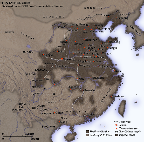
English: Map of the Qin Dynasty (in c. 210 BCE) — in China. ::*The first unifying Imperial dynasty of China. ::*The coloured territories show the approximate extent of Qin political control at the death of Emperor Qin Shi Huang in 210 BC.
As part of his unification of China in 221 BCE, Qin Shi Huang divided his empire into thirty six commanderies, each subdivided into a number of counties. The significance of the administrative reforms was its introduction of a uniformly centralised system of imperial control. At the death of Qin Shi Huang in 210 BCE, more commanderies were added to the original thirty six, and these are also shown on the map.
  • The system was followed by the Han Dynasty (206 BCE – 220 CE), though with a certain degree of compromise. Thereafter, the system became the norm for later dynasties and eventually evolved into the present administrative structure of Mainland China (see: Category: Political divisions of China.) The location of the Yellow River and commandery seats follows Tan Qixiang (ed.), Zhongguo lishi ditu (中国历史地图集), 1982. Note that the Yellow River is considerably to the north of its present flow. ;Credits Created and copyright (2006) by Yeu Ninje. Released under the GNU FDL. Originally uploaded to English Wikipedia by en:User:Yeu Ninje.
  • Han civilisation
    Han civilisation
मिति 1982. (2006).
स्रोत Self-published work by Itsmine
लेखक Itsmine
This historical map image could be re-created using vector graphics as an SVG file. This has several advantages; see Commons:Media for cleanup for more information. If an SVG form of this image is available, please upload it and afterwards replace this template with {{vector version available|new image name}}.


It is recommended to name the SVG file “Qin empire 210 BCE.svg”—then the template Vector version available (or Vva) does not need the new image name parameter.

अनुज्ञा प्राप्त गर्दै

I, the copyright holder of this work, hereby publish it under the following licenses:
GNU head यस दस्तावेजलाई स्वतन्त्र सफ्टवायर फाउन्डेसन द्वारा प्रकाशित जी॰एन॰यू फ्रि डक्यूमेन्टेशन लाइसेन्स को संस्करण 1.2 वा नयाँ (बिना कुनै इन्वेरियेन्ट अनुभाग र पछिल्लो वा पहिलो आवरणका पाठका) को अन्तर्गत कपी, वितरित एवं/अथवा परिवर्तित गर्ने अनुमति प्रदान गरिन्छ । यस लाइसेन्सको एक प्रति जी॰एन॰यू फ्रि डक्यूमेन्टेशन लाइसेन्स नामक अनुभागमा शामिल छ ।
w:en:Creative Commons
एट्रिब्युसन शेयर अलाइक
यो फाइल क्रिएटिभ कमन्स एट्रिब्युसन-सेयर एलाइक ३.० अनपोर्टेड लाइसेन्स अनुसारको अनुमति प्राप्त छ।
तपाईं स्वतन्त्र हुनुहुन्छ :
  • साझेदारी गर्नुहाेस् – रचनालाई कपी, वितरित तथा संचारित गर्नको लागि
  • रिमिक्स गर्नको लागि – काम अनुकूलित गर्नको लागि
निम्नलिखित कारणहरूको अन्तर्गत:
  • एट्रिब्युसन – तपाईंले रचनाको श्रेय अनुमतिपत्रकर्ता अथवा लेखकले बताएको माध्यमले दिनु पर्नेछ (तर यस प्रकार हैन, जसमा लागोस् की उ तपाईंलाई अथवा तपाईंको रचनाको प्रयोगलाई समर्थन गर्छन्)।
  • शेयर अलाइक – यदि तपाई यस रचनामा कुनै परिवर्तन अथवा संसोधन गर्नुहुन्छ या यसमा आधारित केही रचना गर्नुहुन्छ भने तपाई निष्कर्ष स्वरूप बनेको रचनालाई मात्र यहाँ अथवा यसको समान कुनै अनिमति पत्र अन्तर्गत वितरित गर्न सक्नुहुन्छ।
This licensing tag was added to this file as part of the GFDL licensing update.
तपाईँ आफ्नो मनपर्ने इजाजतपत्र रोज्न सक्नुहुन्छ ।

Captions

Add a one-line explanation of what this file represents
A map of the Qin Dynasty circa 210 BCE.

Items portrayed in this file

जनाउँछ

some value

Wikimedia username अङ्ग्रेजी: Itsmine
author name string अङ्ग्रेजी: Itsmine

copyright status अङ्ग्रेजी

copyrighted अङ्ग्रेजी

copyright license अङ्ग्रेजी

फाइल इतिहास

मिति/समय मा क्लिक गरेर त्यससमयमा यो फाइल कस्तो थियो भनेर हेर्न सकिन्छ ।

मिति/समयछोटो चित्रआकारहरूप्रयोगकर्ताटिप्पणी
हालको२०:२२, १० डिसेम्बर २०१४छोटो चित्र २०:२२, १० डिसेम्बर २०१४ संस्करणको रुपमा५५५×५४५ (५६७ किलोबाइटहरू)Nguyen1310Update to include ''Luo-Yue'' (Vi: ''Lạc Việt'') a member of the Baiyue (100 Yue) peoples, on the map in northern Vietnam.
१९:५३, २१ नोभेम्बर २००६छोटो चित्र १९:५३, २१ नोभेम्बर २००६ संस्करणको रुपमा५५५×५४५ (५४० किलोबाइटहरू)Itsmine== Commentary == As part of his unification of China in 221 BC, Qin Shi Huang divided his empire into thirty six commanderies, each subdivided into a number of counties. The significance of the administrative reforms was its in

यो फाइलसँग कुनै पनि पृष्ठ जोडिएको छैन।

विश्वव्यापी फाइल प्रयोग

निम्न अन्य विकिहरूमा यस फाइलको प्रयोग:

यस फाइलको विश्वव्यापी उपयोगको अधिक जानकारी हेर्नुहोस् ।