
चित्र:US Secession map 1861.svg

Size of this PNG preview of this SVG file: ७८७ × ४८३ पिक्सल. अरु संकल्पहरू: ३२० × १९६ पिक्सल • ६४० × ३९३ पिक्सल • १,०२४ × ६२८ पिक्सल • १,२८० × ७८६ पिक्सल • २,५६० × १,५७१ पिक्सल।
मूल फाइल (SVG फाइल,साधारण ७८७ × ४८३ पिक्सेलहरु, फाइल आकार: १११ किलोबाइटहरू)
| यो विकिमीडिया कमन्सको चित्र हो। त्यहाँ यसको विवरण पृष्ठबाट जानकारी तल देखाइएको छ। कमन्स स्वतन्त्र रूपमा इजाजतपत्र प्राप्त चित्र भण्डार हो। तपाईंले मद्दत गर्न सक्नुहुन्छ। |
सारांश
{{Information
|Description=
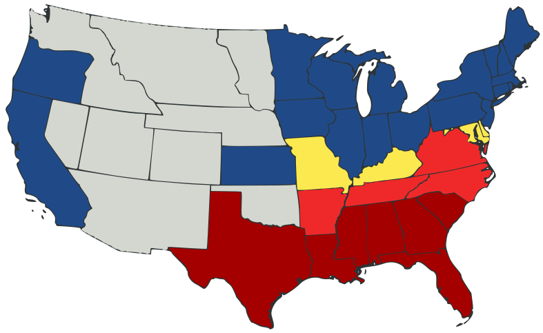
English: United States map of 1861, showing affiliation of states and territories regarding secession from the Union at the start of the American Civil War.
Legend:
States that seceded before April 15, 1861
States that seceded after April 15, 1861
States that permitted slavery, but did not secede
States of the Union where slavery was banned
U.S. territories, under Union Army control
|Date=2007-02-23
|Source=
A trace, retouch, and recolour of Image:Secession Map of the United States, 1861.png by User:Tomf688.
|Author=[[User:ions= |Other fields= }}
अनुज्ञा प्राप्त गर्दै
यो फाइल क्रिएटिभ कमन्स एट्रिब्युसन-सेयर एलाइक ३.० अनपोर्टेड लाइसेन्स अनुसारको अनुमति प्राप्त छ।
- तपाईं स्वतन्त्र हुनुहुन्छ :
- साझेदारी गर्नुहाेस् – रचनालाई कपी, वितरित तथा संचारित गर्नको लागि
- रिमिक्स गर्नको लागि – काम अनुकूलित गर्नको लागि
- निम्नलिखित कारणहरूको अन्तर्गत:
- एट्रिब्युसन – तपाईंले रचनाको श्रेय अनुमतिपत्रकर्ता अथवा लेखकले बताएको माध्यमले दिनु पर्नेछ (तर यस प्रकार हैन, जसमा लागोस् की उ तपाईंलाई अथवा तपाईंको रचनाको प्रयोगलाई समर्थन गर्छन्)।
- शेयर अलाइक – यदि तपाई यस रचनामा कुनै परिवर्तन अथवा संसोधन गर्नुहुन्छ या यसमा आधारित केही रचना गर्नुहुन्छ भने तपाई निष्कर्ष स्वरूप बनेको रचनालाई मात्र यहाँ अथवा यसको समान कुनै अनिमति पत्र अन्तर्गत वितरित गर्न सक्नुहुन्छ।
फाइल इतिहास
मिति/समय मा क्लिक गरेर त्यससमयमा यो फाइल कस्तो थियो भनेर हेर्न सकिन्छ ।
| मिति/समय | छोटो चित्र | आकारहरू | प्रयोगकर्ता | टिप्पणी | |
|---|---|---|---|---|---|
| हालको | ०५:३२, २४ फेब्रुअरी २००७ | | ७८७×४८३ (१११ किलोबाइटहरू) | Tintazul | {{Tintazul |Description=United States map of 1861, show affiliation of states and territories regarding the Secession War (Civil War.) Legend: {{legend|#A40000|States that seceded before April 15, 1861}} {{legend|#EF2929|States that seceded after April 15 |
फाइल प्रयोग
यस फाइलमा निम्न पृष्ठ जोडिन्छ:
विश्वव्यापी फाइल प्रयोग
निम्न अन्य विकिहरूमा यस फाइलको प्रयोग:
- ar.wikipedia.org मा उपयोग
- arz.wikipedia.org मा उपयोग
- be.wikipedia.org मा उपयोग
- bg.wikipedia.org मा उपयोग
- bs.wikipedia.org मा उपयोग
- cy.wikipedia.org मा उपयोग
- da.wikipedia.org मा उपयोग
- el.wikipedia.org मा उपयोग
- en.wikipedia.org मा उपयोग
- American Civil War
- Irredentism
- Origins of the American Civil War
- User:Jimmuldrow/Sandbox
- Upland South
- User:ArmyAnt/Sandbox
- Presidency of Abraham Lincoln
- Presidency of James Buchanan
- James Buchanan
- Central Confederacy
- User:Themaster1112/sandbox
- User:2know4power/sandbox
- User:LukeRun82
- User:Orser67/Lincoln
- es.wikipedia.org मा उपयोग
- eu.wikipedia.org मा उपयोग
- gd.wikipedia.org मा उपयोग
- he.wikipedia.org मा उपयोग
- hr.wikipedia.org मा उपयोग
- hy.wikipedia.org मा उपयोग
- it.wikipedia.org मा उपयोग
- ka.wikipedia.org मा उपयोग
- lij.wikipedia.org मा उपयोग
- lt.wikipedia.org मा उपयोग
- ml.wikipedia.org मा उपयोग
- no.wikipedia.org मा उपयोग
- pl.wikipedia.org मा उपयोग
- pt.wikipedia.org मा उपयोग
- ro.wikipedia.org मा उपयोग
यस फाइलको विश्वव्यापी उपयोगको अधिक जानकारी हेर्नुहोस् ।