
चित्र:Abbasid Caliphate 891-892.png

यस पूर्व रुपको आकार: ८०० × ३८२ पिक्सल। अरु संकल्पहरू: ३२० × १५३ पिक्सल • ६४० × ३०६ पिक्सल • १,०२४ × ४९० पिक्सल • १,२८० × ६१२ पिक्सल • ३,०५४ × १,४६० पिक्सल।
मूल फाइल (३,०५४ × १,४६० पिक्सेलहरू, फाइल आकार: १.४४ मेगाबाइटहरू, MIME प्रकार: image/png)
| यो विकिमीडिया कमन्सको चित्र हो। त्यहाँ यसको विवरण पृष्ठबाट जानकारी तल देखाइएको छ। कमन्स स्वतन्त्र रूपमा इजाजतपत्र प्राप्त चित्र भण्डार हो। तपाईंले मद्दत गर्न सक्नुहुन्छ। |
सारांश
| वर्णन |
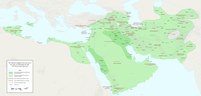
English: Map of the Abbasid Caliphate at the end of the reign of al-Mu'tamid in 891-892. Dark green denotes provinces under the effective control of the central government; light green denotes provinces under the control of autonomous governors or rebels.
The core Abbasid territories include Shahrazur, Darabadh, al-Samaghan, Hulwan, Masabadhan, Mihrijanqadhaq, the Euphrates districts, and Qarqisiyya (al-Tabari v. 37, p. 98; Bianquis p. 96). Map originally created as an .SVG file in Inkscape and converted to .PNG for size reasons. Background topography taken from DEMIS Mapserver, which are public domain. Works Cited:
|
| मिति | |
| स्रोत | मेरो आफ्नै कार्य |
| लेखक | Ro4444 |
| अरु संस्करणहरू |
 |
अनुज्ञा प्राप्त गर्दै
I, the copyright holder of this work, hereby publish it under the following license:
This file is licensed under the Creative Commons Attribution-Share Alike 4.0 International license.
- तपाईं स्वतन्त्र हुनुहुन्छ :
- साझेदारी गर्नुहाेस् – रचनालाई कपी, वितरित तथा संचारित गर्नको लागि
- रिमिक्स गर्नको लागि – काम अनुकूलित गर्नको लागि
- निम्नलिखित कारणहरूको अन्तर्गत:
- एट्रिब्युसन – तपाईंले रचनाको श्रेय अनुमतिपत्रकर्ता अथवा लेखकले बताएको माध्यमले दिनु पर्नेछ (तर यस प्रकार हैन, जसमा लागोस् की उ तपाईंलाई अथवा तपाईंको रचनाको प्रयोगलाई समर्थन गर्छन्)।
- शेयर अलाइक – यदि तपाई यस रचनामा कुनै परिवर्तन अथवा संसोधन गर्नुहुन्छ या यसमा आधारित केही रचना गर्नुहुन्छ भने तपाई निष्कर्ष स्वरूप बनेको रचनालाई मात्र यहाँ अथवा यसको समान कुनै अनिमति पत्र अन्तर्गत वितरित गर्न सक्नुहुन्छ।
फाइल इतिहास
मिति/समय मा क्लिक गरेर त्यससमयमा यो फाइल कस्तो थियो भनेर हेर्न सकिन्छ ।
| मिति/समय | छोटो चित्र | आकारहरू | प्रयोगकर्ता | टिप्पणी | |
|---|---|---|---|---|---|
| हालको | ०५:०३, ४ डिसेम्बर २०१७ | | ३,०५४×१,४६० (१.४४ मेगाबाइटहरू) | Ro4444 | Further color corrections |
| ०४:३५, ४ डिसेम्बर २०१७ |  | ३,०५४×१,४६० (१.४४ मेगाबाइटहरू) | Ro4444 | Color correction | |
| ०२:५६, ४ डिसेम्बर २०१७ |  | ३,०५४×१,४६० (१.४४ मेगाबाइटहरू) | Ro4444 | User created page with UploadWizard |
फाइल प्रयोग
यो फाइलसँग कुनै पनि पृष्ठ जोडिएको छैन।
विश्वव्यापी फाइल प्रयोग
निम्न अन्य विकिहरूमा यस फाइलको प्रयोग:
- ar.wikipedia.org मा उपयोग
- de.wikiversity.org मा उपयोग
- en.wikipedia.org मा उपयोग
- en.wikibooks.org मा उपयोग
- et.wikipedia.org मा उपयोग
- fa.wikipedia.org मा उपयोग
- hy.wikipedia.org मा उपयोग
- id.wikipedia.org मा उपयोग
- ja.wikipedia.org मा उपयोग
- no.wikipedia.org मा उपयोग
- pt.wikipedia.org मा उपयोग
- sco.wikipedia.org मा उपयोग
- uk.wikipedia.org मा उपयोग
- uz.wikipedia.org मा उपयोग
- zh.wikipedia.org मा उपयोग