
चित्र:Map of North America with the Western Interior Seaway during the Campanian (Upper Cretaceous).png

यस पूर्व रुपको आकार: ४८८ × ६०० पिक्सल। अरु संकल्पहरू: १९५ × २४० पिक्सल • ३९० × ४८० पिक्सल • ६२५ × ७६८ पिक्सल • ८३३ × १,०२४ पिक्सल • १,९४५ × २,३९१ पिक्सल।
मूल फाइल (१,९४५ × २,३९१ पिक्सेलहरू, फाइल आकार: ३.९५ मेगाबाइटहरू, MIME प्रकार: image/png)
| यो विकिमीडिया कमन्सको चित्र हो। त्यहाँ यसको विवरण पृष्ठबाट जानकारी तल देखाइएको छ। कमन्स स्वतन्त्र रूपमा इजाजतपत्र प्राप्त चित्र भण्डार हो। तपाईंले मद्दत गर्न सक्नुहुन्छ। |
.png)
सारांश
| वर्णन |
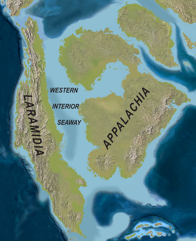
English: Map of North America with the Western Interior Seaway during the Campanian (Upper Cretaceous). Paleogeography of North America during the late Campanian Stage of the Late Cretaceous (∼75 Ma). Modified after Blakey.
Deutsch: Karte von Nordamerika mit dem Western Interior Seaway während des Campaniums (Obere Kreide) |
| मिति | |
| स्रोत | http://www.plosone.org/article/info%3Adoi%2F10.1371%2Fjournal.pone.0012292 |
| लेखक | Scott D. Sampson, Mark A. Loewen, Andrew A. Farke, Eric M. Roberts, Catherine A. Forster, Joshua A. Smith, Alan L. Titus |
| अनुमति (यो फाइल पुनप्रयोग गर्न) |
http://www.plosbiology.org/static/license.action |
अनुज्ञा प्राप्त गर्दै
This file is licensed under the Creative Commons Attribution 4.0 International license.
- तपाईं स्वतन्त्र हुनुहुन्छ :
- साझेदारी गर्नुहाेस् – रचनालाई कपी, वितरित तथा संचारित गर्नको लागि
- रिमिक्स गर्नको लागि – काम अनुकूलित गर्नको लागि
- निम्नलिखित कारणहरूको अन्तर्गत:
- एट्रिब्युसन – तपाईंले रचनाको श्रेय अनुमतिपत्रकर्ता अथवा लेखकले बताएको माध्यमले दिनु पर्नेछ (तर यस प्रकार हैन, जसमा लागोस् की उ तपाईंलाई अथवा तपाईंको रचनाको प्रयोगलाई समर्थन गर्छन्)।
फाइल इतिहास
मिति/समय मा क्लिक गरेर त्यससमयमा यो फाइल कस्तो थियो भनेर हेर्न सकिन्छ ।
| मिति/समय | छोटो चित्र | आकारहरू | प्रयोगकर्ता | टिप्पणी | |
|---|---|---|---|---|---|
| हालको | ०२:५३, २ अप्रिल २०२० | | १,९४५×२,३९१ (३.९५ मेगाबाइटहरू) | FunkMonk | {{Information |Description = {{en|1=Map of North America with the Western Interior Seaway during the Campanian (Upper Cretaceous). Paleogeography of North America during the late Campanian Stage of the Late Cretaceous (∼75 Ma). Modified after Blakey.}} {{de|1=Karte von Nordamerika mit dem Western Interior Seaway während des Campaniums (Obere Kreide)}} |Source =http://www.plosone.org/article/info%3Adoi%2F10.1371%2Fjournal.pone.0012292 |Author =Scott D. Sampson, Mark A. Loewe... |
फाइल प्रयोग
यस फाइलमा निम्न पृष्ठ जोडिन्छ:
विश्वव्यापी फाइल प्रयोग
निम्न अन्य विकिहरूमा यस फाइलको प्रयोग:
- de.wiktionary.org मा उपयोग
- en.wikipedia.org मा उपयोग
- fa.wikipedia.org मा उपयोग
- fr.wikipedia.org मा उपयोग
- id.wikipedia.org मा उपयोग
- it.wikipedia.org मा उपयोग
- nl.wikipedia.org मा उपयोग
- pl.wikipedia.org मा उपयोग
- pl.wiktionary.org मा उपयोग
- pt.wikipedia.org मा उपयोग
- ru.wikipedia.org मा उपयोग
- tr.wikipedia.org मा उपयोग
- uk.wikipedia.org मा उपयोग
- zh.wikipedia.org मा उपयोग
.png)