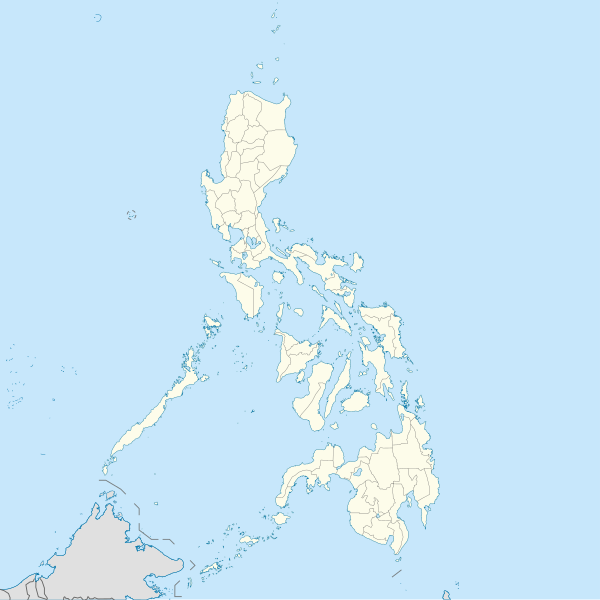
चित्र:Philippines location map (square).svg
स्वरूप

Size of this PNG preview of this SVG file: ६०० × ६०० पिक्सल. अरु संकल्पहरू: २४० × २४० पिक्सल • ४८० × ४८० पिक्सल • ७६८ × ७६८ पिक्सल • १,०२४ × १,०२४ पिक्सल • २,०४८ × २,०४८ पिक्सल • १,३३२ × १,३३२ पिक्सल।
मूल फाइल (SVG फाइल,साधारण १,३३२ × १,३३२ पिक्सेलहरु, फाइल आकार: १.४९ मेगाबाइटहरू)
फाइल इतिहास
मिति/समय मा क्लिक गरेर त्यससमयमा यो फाइल कस्तो थियो भनेर हेर्न सकिन्छ ।
| मिति/समय | छोटो चित्र | आकारहरू | प्रयोगकर्ता | टिप्पणी | |
|---|---|---|---|---|---|
| हालको | १६:०२, १९ अगस्ट २०२१ |  | १,३३२×१,३३२ (१.४९ मेगाबाइटहरू) | AichiWikiFixer | Updated boundaries |
| १३:३८, १८ जुन २०२१ |  | १,३३२×१,३३२ (२.२४ मेगाबाइटहरू) | AichiWikiFixer | Map update. | |
| ०९:४०, १८ जुन २०२१ |  | १,३३२×१,३३२ (२.२३ मेगाबाइटहरू) | AichiWikiFixer | Small changes. | |
| ०९:३४, १८ जुन २०२१ |  | १,३३२×१,३३२ (२.२३ मेगाबाइटहरू) | AichiWikiFixer | External changes for boundaries and coastlines. | |
| १८:५६, १७ जुन २०२१ |  | १,३३२×१,३३२ (२.२३ मेगाबाइटहरू) | AichiWikiFixer | Additional islands, lakes, and updated coastlines. | |
| १६:१९, १७ जुन २०२१ |  | १,३३२×१,३३२ (२.२३ मेगाबाइटहरू) | AichiWikiFixer | Update boundaries. | |
| ०७:४९, २५ मे २०२१ |  | १,३३२×१,३३२ (२.२२ मेगाबाइटहरू) | HueMan1 | Reverted to version as of 07:24, 7 September 2020 (UTC) | |
| १२:५६, १७ मे २०२१ |  | १,३३२×१,३३२ (३.७२ मेगाबाइटहरू) | Petriolo | Reverted to version as of 05:36, 3 May 2021 (UTC) The new administrative borders are based from the Philippine government websites (https://www.geoportal.gov.ph/; http://noah.up.edu.ph/), and is deemed accurate. These new files have reliable sources and there's no "beauty" in it if it is inaccurate in the first place. | |
| १९:४५, १६ मे २०२१ |  | १,३३२×१,३३२ (२.२२ मेगाबाइटहरू) | AichiWikiFixer | Reverted to version as of 07:24, 7 September 2020 (UTC) (Borders seen as ugly) | |
| ११:२१, ३ मे २०२१ |  | १,३३२×१,३३२ (३.७२ मेगाबाइटहरू) | Petriolo | updated with NAMRIA borders |
फाइल प्रयोग
यस फाइलमा निम्न पृष्ठ जोडिन्छ:
विश्वव्यापी फाइल प्रयोग
निम्न अन्य विकिहरूमा यस फाइलको प्रयोग:
- af.wikipedia.org मा उपयोग
- ar.wikipedia.org मा उपयोग
- arz.wikipedia.org मा उपयोग
- ast.wikipedia.org मा उपयोग
- Asturias (Filipines)
- Toboso
- Lucena (Filipines)
- Alcala
- Manila
- Módulu:Mapa de llocalización/datos/Filipines
- Mar de Joló
- Luzón
- Komisyon sa Wikang Filipino
- Mar de Visayas
- Mindanao
- Lingayén
- Tarlac
- Vigan
- Arrozales en terraces de los cordales de Filipines
- Dávao
- Complexu del Batasang Pambansa
- Ríu Pásig
- Estrechu de Mindoro
- Estrechu de Luzón
- Islles de Calamianes
- Módulu:Mapa de llocalización/datos/Filipines/usu
- Aeropuertu Internacional Ninoy Aquino
- Pasay
- Parañaque
- Universidá de Bulacán
- Aeropuertu Daniel Z. Romuáldez
- Aeropuertu Evelio Javier
- Aeropuertu Francisco B. Reyes
- Aeropuertu Godofredo P. Ramos
- Aeropuertu d'Awang
- Aeropuertu de Bancasi
- Aeropuertu de Dipolog
- Aeropuertu d'Ipil
- Aeropuertu de Joló
- Aeropuertu de Labo
- Aeropuertu de Laguindingán
- Aeropuertu de Lumbia
- Aeropuertu de Naga
- Aeropuertu de Pagadían
यस फाइलको विश्वव्यापी उपयोगको अधिक जानकारी हेर्नुहोस् ।
