
चित्र:Sri Lanka geopolitics, 1520s.png
यस पूर्व रुपको आकार: ४४४ × ५९९ पिक्सल। अरु संकल्पहरू: १७८ × २४० पिक्सल • ३५६ × ४८० पिक्सल • ७०० × ९४४ पिक्सल।
मूल फाइल (७०० × ९४४ पिक्सेलहरू, फाइल आकार: ७०३ किलोबाइटहरू, MIME प्रकार: image/png)
| यो विकिमीडिया कमन्सको चित्र हो। त्यहाँ यसको विवरण पृष्ठबाट जानकारी तल देखाइएको छ। कमन्स स्वतन्त्र रूपमा इजाजतपत्र प्राप्त चित्र भण्डार हो। तपाईंले मद्दत गर्न सक्नुहुन्छ। |
सारांश
| वर्णन |
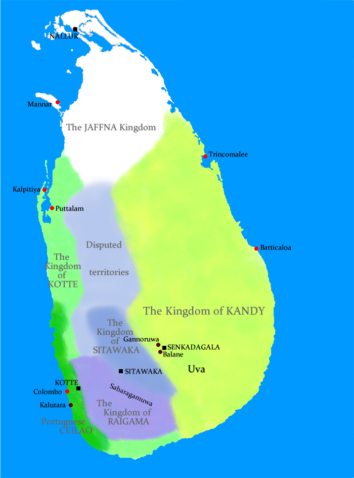
Geopolitical situation in Sri Lanka in the 1520s This map has serious errors - Colombo is marked wrong and according to the map, Anuradhapura is shown as part of Jaffna Kingdom. No References are given either. |
| मिति | २१ अगस्ट २००९ (original upload date) |
| स्रोत | No machine-readable source provided. Own work assumed (based on copyright claims). |
| लेखक | No machine-readable author provided. Docsubster assumed (based on copyright claims). |
अनुज्ञा प्राप्त गर्दै
| I, the copyright holder of this work, release this work into the public domain. This applies worldwide. In some countries this may not be legally possible; if so: I grant anyone the right to use this work for any purpose, without any conditions, unless such conditions are required by law. |
फाइल इतिहास
मिति/समय मा क्लिक गरेर त्यससमयमा यो फाइल कस्तो थियो भनेर हेर्न सकिन्छ ।
| मिति/समय | छोटो चित्र | आकारहरू | प्रयोगकर्ता | टिप्पणी | |
|---|---|---|---|---|---|
| हालको | १९:३९, २१ अगस्ट २००९ | | ७००×९४४ (७०३ किलोबाइटहरू) | Docsubster | Geopolitical situation in Sri Lanka in the 1520s |
फाइल प्रयोग
यस फाइलमा निम्न पृष्ठ जोडिन्छ:
विश्वव्यापी फाइल प्रयोग
निम्न अन्य विकिहरूमा यस फाइलको प्रयोग:
- ar.wikipedia.org मा उपयोग
- de.wikipedia.org मा उपयोग
- en.wikipedia.org मा उपयोग
- id.wikipedia.org मा उपयोग
- io.wikipedia.org मा उपयोग
- it.wikipedia.org मा उपयोग
- ru.wikipedia.org मा उपयोग
- ta.wikipedia.org मा उपयोग
- uk.wikipedia.org मा उपयोग