
चित्र:Srivijaya Empire.svg

Size of this PNG preview of this SVG file: ४६८ × ४७६ पिक्सल. अरु संकल्पहरू: २३६ × २४० पिक्सल • ४७२ × ४८० पिक्सल • ७५५ × ७६८ पिक्सल • १,००७ × १,०२४ पिक्सल • २,०१४ × २,०४८ पिक्सल।
मूल फाइल (SVG फाइल,साधारण ४६८ × ४७६ पिक्सेलहरु, फाइल आकार: ३३६ किलोबाइटहरू)
| यो विकिमीडिया कमन्सको चित्र हो। त्यहाँ यसको विवरण पृष्ठबाट जानकारी तल देखाइएको छ। कमन्स स्वतन्त्र रूपमा इजाजतपत्र प्राप्त चित्र भण्डार हो। तपाईंले मद्दत गर्न सक्नुहुन्छ। |
सारांश
| वर्णन |
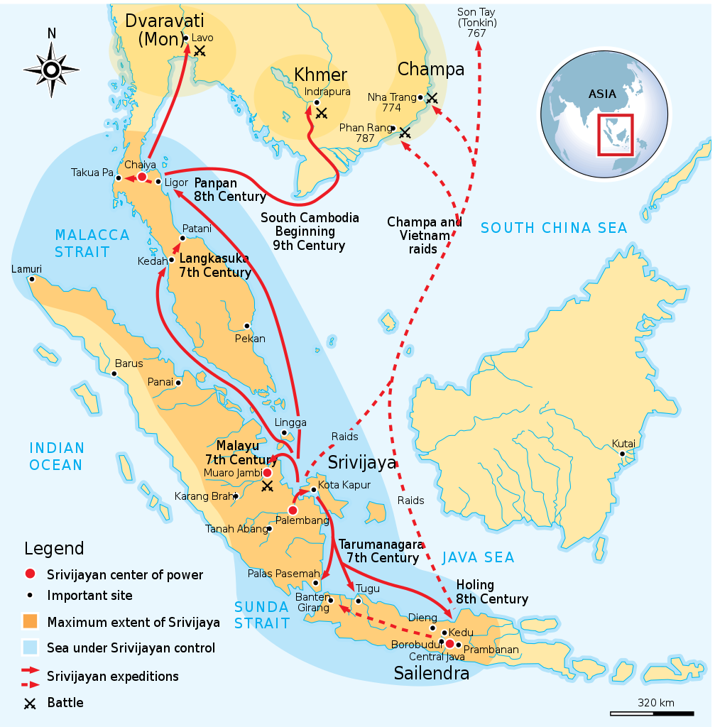
English: Maximum extent of Srivijaya Empire around 8th century. Expanding from Sumatra, Central Java, to Malay Peninsula. The red arrows show the series of Srivijayan expedition and conquest, in diplomatic alliances, military campaign, or naval raids. |
||
| मिति | |||
| स्रोत | Own work by uploader,redrawed from Munoz "Early Kingdoms of the Indonesian Archipelago and the Malay Peninsula" page 128 | ||
| लेखक | Gunawan Kartapranata | ||
| अनुमति (यो फाइल पुनप्रयोग गर्न) |
I, the copyright holder of this work, hereby publish it under the following licenses: यो फाइल क्रिएटिभ कमन्स एट्रिब्युसन-सेयर एलाइक ३.० अनपोर्टेड लाइसेन्स अनुसारको अनुमति प्राप्त छ।
तपाईँ आफ्नो मनपर्ने इजाजतपत्र रोज्न सक्नुहुन्छ । |
||
| अरु संस्करणहरू |
[]
|


|
This SVG file contains embedded text that can be translated into your language, using any capable SVG editor, text editor or the SVG Translate tool. For more information see: About translating SVG files. |
References
Resources used to create the map:
- Munoz, Paul Michel (२००६) Early Kingdoms of the Indonesian Archipelago and the Malay Peninsula, सिंगापुर: Editions Didier Millet, pp. 128, 141 ISBN: 9814155675.
फाइल इतिहास
मिति/समय मा क्लिक गरेर त्यससमयमा यो फाइल कस्तो थियो भनेर हेर्न सकिन्छ ।
| मिति/समय | छोटो चित्र | आकारहरू | प्रयोगकर्ता | टिप्पणी | |
|---|---|---|---|---|---|
| हालको | ०४:२६, ४ डिसेम्बर २०१४ | | ४६८×४७६ (३३६ किलोबाइटहरू) | Pratyeka | Reposition 'Malacca Straight' label for improved clarity. |
| ०४:१८, ४ डिसेम्बर २०१४ |  | ४६८×४७६ (३३६ किलोबाइटहरू) | Pratyeka | Addition of Lamuri, an important point in northwestern Sumatra identified as contemporary and whose location at Lhok Lambaro is reasoned by E. Edwards McKinnon in ''[http://www.scribd.com/doc/8410125/A-note-of-Lamuri-Lambri-Sumatra-Straits-of-Melaka-Ma... | |
| ०१:००, २७ अगस्ट २००९ |  | ४६८×४७६ (२८८ किलोबाइटहरू) | Gunkarta | {{Information |Description={{en|1=Maximum extent of Srivijaya Empire around 8th century. Expanding from Sumatra, Central Java, to Malay Peninsula. The red arrows show the series of Srivijayan expedition and conquest, in diplomatic alliances, military camp |
फाइल प्रयोग
यस फाइलमा निम्न पृष्ठ जोडिन्छ:
विश्वव्यापी फाइल प्रयोग
निम्न अन्य विकिहरूमा यस फाइलको प्रयोग:
- azb.wikipedia.org मा उपयोग
- ba.wikipedia.org मा उपयोग
- be.wikipedia.org मा उपयोग
- bg.wikipedia.org मा उपयोग
- bn.wikipedia.org मा उपयोग
- ca.wikipedia.org मा उपयोग
- cs.wikipedia.org मा उपयोग
- da.wikipedia.org मा उपयोग
- en.wikipedia.org मा उपयोग
- eo.wikipedia.org मा उपयोग
- fa.wikipedia.org मा उपयोग
- fi.wikibooks.org मा उपयोग
- ha.wikipedia.org मा उपयोग
- hi.wikipedia.org मा उपयोग
- hu.wikipedia.org मा उपयोग
- hy.wikipedia.org मा उपयोग
- id.wikipedia.org मा उपयोग
- io.wikipedia.org मा उपयोग
- it.wikipedia.org मा उपयोग
- ja.wikipedia.org मा उपयोग
- ja.wikibooks.org मा उपयोग
- ka.wikipedia.org मा उपयोग
- km.wikipedia.org मा उपयोग
- ko.wikipedia.org मा उपयोग
- lt.wikipedia.org मा उपयोग
- lv.wikipedia.org मा उपयोग
- min.wikipedia.org मा उपयोग
- ml.wikipedia.org मा उपयोग
- mr.wikipedia.org मा उपयोग
यस फाइलको विश्वव्यापी उपयोगको अधिक जानकारी हेर्नुहोस् ।