
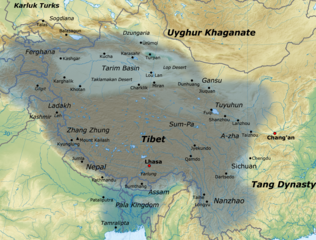
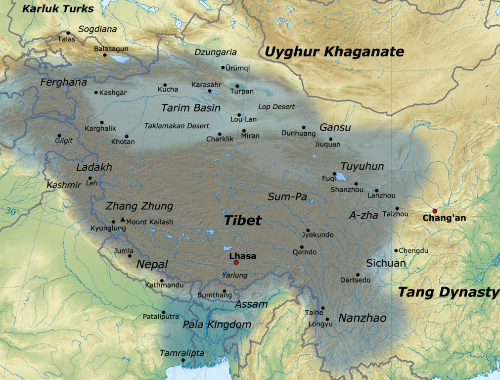
चित्र:Tibetan empire greatest extent 780s-790s CE.png

यस पूर्व रुपको आकार: ७९० × ६०० पिक्सल। अरु संकल्पहरू: ३१६ × २४० पिक्सल • ६३२ × ४८० पिक्सल • १,०११ × ७६८ पिक्सल • १,२८० × ९७२ पिक्सल • १,७९२ × १,३६१ पिक्सल।
मूल फाइल (१,७९२ × १,३६१ पिक्सेलहरू, फाइल आकार: ४.५५ मेगाबाइटहरू, MIME प्रकार: image/png)
| यो विकिमीडिया कमन्सको चित्र हो। त्यहाँ यसको विवरण पृष्ठबाट जानकारी तल देखाइएको छ। कमन्स स्वतन्त्र रूपमा इजाजतपत्र प्राप्त चित्र भण्डार हो। तपाईंले मद्दत गर्न सक्नुहुन्छ। |
सारांश

|
This historical map image could be re-created using vector graphics as an SVG file. This has several advantages; see Commons:Media for cleanup for more information. If an SVG form of this image is available, please upload it and afterwards replace this template with
{{vector version available|new image name}}.
It is recommended to name the SVG file “Tibetan empire greatest extent 780s-790s CE.svg”—then the template Vector version available (or Vva) does not need the new image name parameter. |
| वर्णन |
English: Map of the Tibetan Empire at its greatest extent between the 780s and the 790s CE
sources:
|
| मिति | |
| स्रोत | मेरो आफ्नै कार्य |
| लेखक | Javierfv1212 |
अनुज्ञा प्राप्त गर्दै
I, the copyright holder of this work, hereby publish it under the following license:
This file is licensed under the Creative Commons Attribution 3.0 Unported license.
- तपाईं स्वतन्त्र हुनुहुन्छ :
- साझेदारी गर्नुहाेस् – रचनालाई कपी, वितरित तथा संचारित गर्नको लागि
- रिमिक्स गर्नको लागि – काम अनुकूलित गर्नको लागि
- निम्नलिखित कारणहरूको अन्तर्गत:
- एट्रिब्युसन – तपाईंले रचनाको श्रेय अनुमतिपत्रकर्ता अथवा लेखकले बताएको माध्यमले दिनु पर्नेछ (तर यस प्रकार हैन, जसमा लागोस् की उ तपाईंलाई अथवा तपाईंको रचनाको प्रयोगलाई समर्थन गर्छन्)।
फाइल इतिहास
मिति/समय मा क्लिक गरेर त्यससमयमा यो फाइल कस्तो थियो भनेर हेर्न सकिन्छ ।
| मिति/समय | छोटो चित्र | आकारहरू | प्रयोगकर्ता | टिप्पणी | |
|---|---|---|---|---|---|
| हालको | २१:५६, १६ जनवरी २०२१ | | १,७९२×१,३६१ (४.५५ मेगाबाइटहरू) | Liandrei | Cropped black border |
| २१:४५, २९ मार्च २०११ |  | १,८००×१,३६१ (४.५६ मेगाबाइटहरू) | Javierfv1212 | {{Information |Description ={{en|1=Map of the Tibetan empire at it's Greatest extent between the 780s and the 790s CE sources: http://academic.reed.edu/anthro/364/maps.html http://unitednations4freetibet.com/unfft/wp-content/uploads/2010/11/The-Nation |
फाइल प्रयोग
यस फाइलमा निम्न पृष्ठ जोडिन्छ:
विश्वव्यापी फाइल प्रयोग
निम्न अन्य विकिहरूमा यस फाइलको प्रयोग:
- af.wikipedia.org मा उपयोग
- ar.wikipedia.org मा उपयोग
- azb.wikipedia.org मा उपयोग
- az.wikipedia.org मा उपयोग
- ba.wikipedia.org मा उपयोग
- bg.wikipedia.org मा उपयोग
- bn.wikipedia.org मा उपयोग
- bo.wikipedia.org मा उपयोग
- bs.wikipedia.org मा उपयोग
- ca.wikipedia.org मा उपयोग
- cs.wikipedia.org मा उपयोग
- da.wikipedia.org मा उपयोग
- de.wikipedia.org मा उपयोग
- en.wikipedia.org मा उपयोग
- es.wikipedia.org मा उपयोग
- eu.wikipedia.org मा उपयोग
- fa.wikipedia.org मा उपयोग
- fi.wikipedia.org मा उपयोग
- fr.wikipedia.org मा उपयोग
यस फाइलको विश्वव्यापी उपयोगको अधिक जानकारी हेर्नुहोस् ।