
चित्र:Brazil 16thc map.jpg

यस पूर्व रुपको आकार: ८०० × ५६१ पिक्सल। अरु संकल्पहरू: ३२० × २२४ पिक्सल • ६४० × ४४८ पिक्सल • १,०२४ × ७१७ पिक्सल • १,२८० × ८९७ पिक्सल • २,५६० × १,७९४ पिक्सल • १४,०२८ × ९,८२९ पिक्सल।
मूल फाइल (१४,०२८ × ९,८२९ पिक्सेलहरू, फाइल आकार: ३३.५१ मेगाबाइटहरू, MIME प्रकार: image/jpeg)
| यो विकिमीडिया कमन्सको चित्र हो। त्यहाँ यसको विवरण पृष्ठबाट जानकारी तल देखाइएको छ। कमन्स स्वतन्त्र रूपमा इजाजतपत्र प्राप्त चित्र भण्डार हो। तपाईंले मद्दत गर्न सक्नुहुन्छ। |
|
सारांश
| Warning | The original file is very high-resolution. It might not load properly or could cause your browser to freeze when opened at full size. |
|---|
| शीर्षक |
[Atlas nautique du Monde, dit atlas Miller] ; 2-5. [Atlas Miller : feuilles 2 à 5 ]. feuille 5 |
||||||||||||||||||||||||||
| Description |
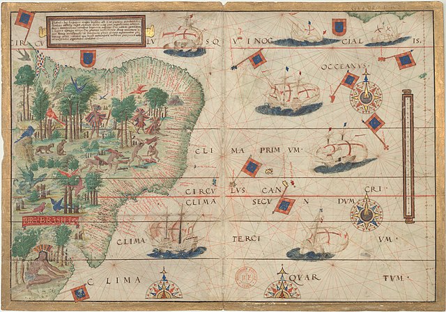
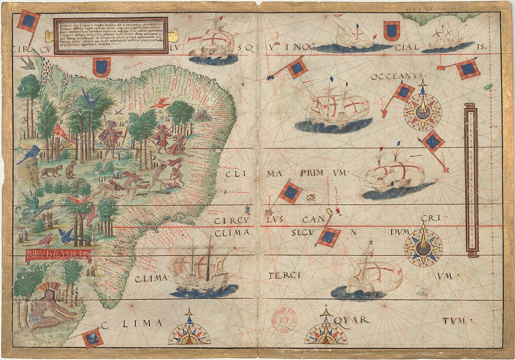
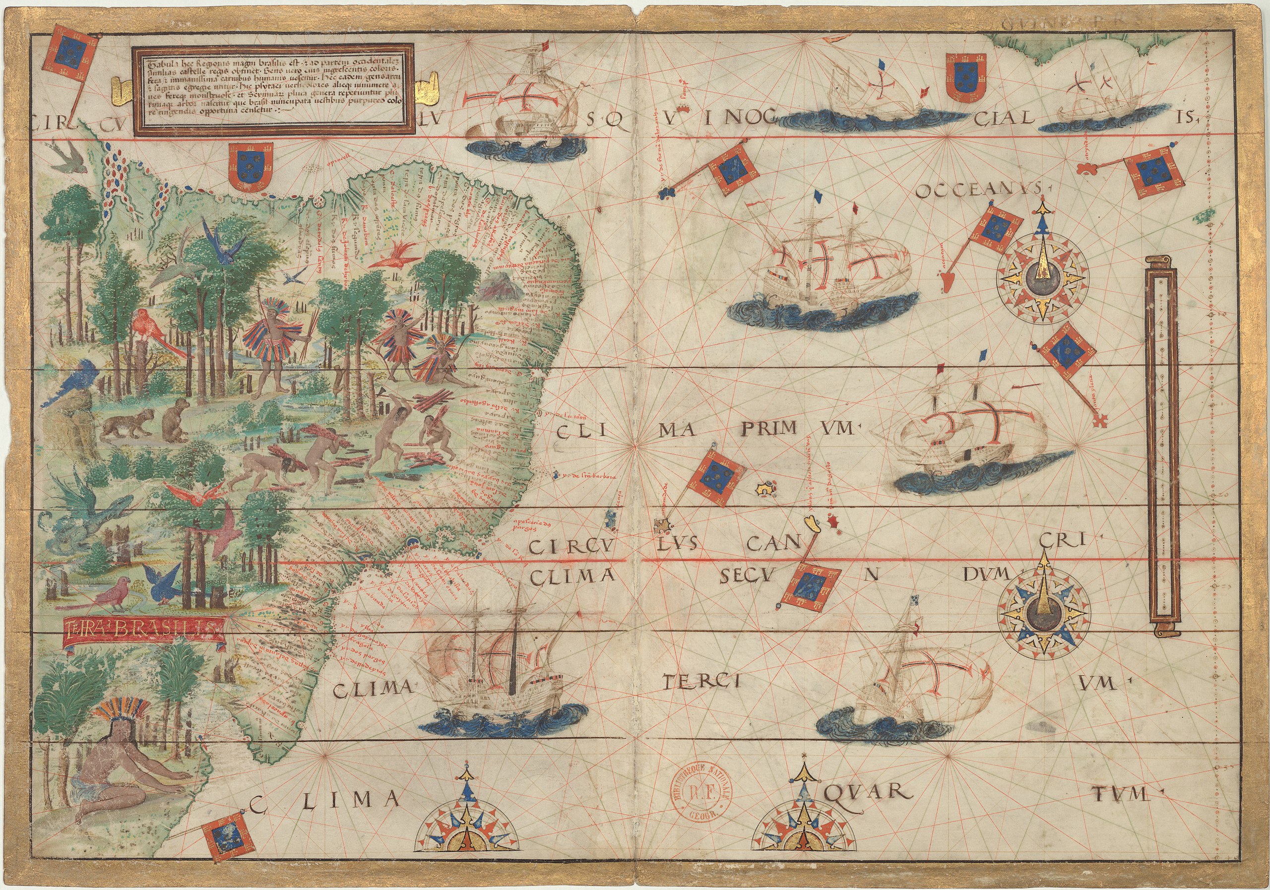
English: Map of Brazil in the Miller Atlas of 1519. |
||||||||||||||||||||||||||
| मिति | |||||||||||||||||||||||||||
| स्रोत |
Bibliothèque nationale de France |
||||||||||||||||||||||||||
| रचनाकार |
|
||||||||||||||||||||||||||
| Georeferencing | If inappropriate please set warp_status = skip to hide. | ||||||||||||||||||||||||||
| Archival data | |||||||||||||||||||||||||||
| Collection |
|
||||||||||||||||||||||||||
| आकारहरू | height: ४२.० cm; width: ५९.० cm | ||||||||||||||||||||||||||
| अरु संस्करणहरू |
 |
||||||||||||||||||||||||||


अनुज्ञा प्राप्त गर्दै
|
This is a faithful photographic reproduction of a two-dimensional, public domain work of art. The work of art itself is in the public domain for the following reason:
The official position taken by the Wikimedia Foundation is that "faithful reproductions of two-dimensional public domain works of art are public domain".
This photographic reproduction is therefore also considered to be in the public domain in the United States. In other jurisdictions, re-use of this content may be restricted; see Reuse of PD-Art photographs for details. | ||||
फाइल इतिहास
मिति/समय मा क्लिक गरेर त्यससमयमा यो फाइल कस्तो थियो भनेर हेर्न सकिन्छ ।
| मिति/समय | छोटो चित्र | आकारहरू | प्रयोगकर्ता | टिप्पणी | |
|---|---|---|---|---|---|
| हालको | ०३:५३, २२ मार्च २०२१ | | १४,०२८×९,८२९ (३३.५१ मेगाबाइटहरू) | Giro720 | full size map |
| २३:०४, १८ जुलाई २००७ |  | १,५००×१,०५९ (१.२१ मेगाबाइटहरू) | Sebastian Wallroth | {{Information |Description={{en|Miller Atlas from 1519 by Pedro Reinel, Jorge Reinel, Lopo Homem (mapmakers), and António de Holanda (miniaturist).}}{{de|Miller Atlas von 1519 von Pedro und Jorge Reinel, Lopo Homem (Kartograp | |
| १५:२८, २० जनवरी २००६ |  | ४००×५४३ (९३ किलोबाइटहरू) | Pedro Aguiar | Colonial map of Brazil, early 16th century. |
फाइल प्रयोग
यो फाइलसँग कुनै पनि पृष्ठ जोडिएको छैन।
विश्वव्यापी फाइल प्रयोग
निम्न अन्य विकिहरूमा यस फाइलको प्रयोग:
- als.wikipedia.org मा उपयोग
- ca.wikipedia.org मा उपयोग
- de.wikipedia.org मा उपयोग
- de.wikisource.org मा उपयोग
- en.wikipedia.org मा उपयोग
- Latin America
- History of Portugal
- Coronelism
- Cangaço
- Milk coffee politics
- Wikipedia:Featured pictures
- Federative units of Brazil
- Colonial Brazil
- First Brazilian Republic
- Wikipedia:Featured picture candidates
- Vargas Era
- Captaincies of Brazil
- Bandeirantes
- Template:History of Brazil
- Fourth Brazilian Republic
- List of mayors of Rio de Janeiro
- Military dictatorship in Brazil
- France Antarctique
- Equinoctial France
- Letter of Pero Vaz de Caminha
- Palmares (quilombo)
- Sierra de la Plata
- Fernão de Loronha
- History of Brazil (1985–present)
- Mensalão scandal
- User:Yug/History: Latin America
- Economic history of Portugal
- Civilizing mission
- Portal:Portugal
- Dutch Brazil
- Pedro Reinel
- 1964 Brazilian coup d'état
- Wikipedia:Userboxes/History
- Marajoara culture
- Name of Brazil
- Slavery in Brazil
- User:Mizunoryu
- Wikipedia:Featured pictures/Diagrams, drawings, and maps/Maps
- History of Brazil
- Transfer of the Portuguese court to Brazil
- History of the Empire of Brazil
- Kuhikugu
यस फाइलको विश्वव्यापी उपयोगको अधिक जानकारी हेर्नुहोस् ।