
चित्र:Habsburg Monarchy 1789.svg

Size of this PNG preview of this SVG file: ४५० × ४५६ पिक्सल. अरु संकल्पहरू: २३७ × २४० पिक्सल • ४७४ × ४८० पिक्सल • ७५८ × ७६८ पिक्सल • १,०११ × १,०२४ पिक्सल • २,०२१ × २,०४८ पिक्सल।
मूल फाइल (SVG फाइल,साधारण ४५० × ४५६ पिक्सेलहरु, फाइल आकार: ८५७ किलोबाइटहरू)
| यो विकिमीडिया कमन्सको चित्र हो। त्यहाँ यसको विवरण पृष्ठबाट जानकारी तल देखाइएको छ। कमन्स स्वतन्त्र रूपमा इजाजतपत्र प्राप्त चित्र भण्डार हो। तपाईंले मद्दत गर्न सक्नुहुन्छ। |
सारांश


.svg)
.svg)
.svg)
.svg)
.svg)


.svg)
.svg)
.svg)


.png)
.png)


.svg)


.svg)

.svg)


.svg)
.svg)
.svg)
.svg)


.svg)
.png)


.svg)


.svg)
.svg)


.svg)


.svg)


.svg)
.svg)
.svg)
.svg)
.svg)
.svg)
.svg)
_cropped.svg)
.svg)
.svg)
.svg)
.svg)
.svg)
.svg)
.svg)
.svg)
.svg)
.svg)
.svg)
.svg)
.svg)
.svg)
.svg)
.svg)
.svg)
.svg)
.svg)
.svg)
.svg)
.svg)
.svg)
.svg)
.svg)
.svg)
.svg)
.svg)
.svg)
.svg)
.svg)
.svg)
.svg)
.svg)
.svg)
.svg)
.svg)
.svg)
.svg)
.svg)
.svg)
.svg)
.svg)
.svg)
.svg)
अनुज्ञा प्राप्त गर्दै
I, the copyright holder of this work, hereby publish it under the following license:
यो फाइल क्रिएटिभ कमन्स एट्रिब्युसन-सेयर एलाइक ३.० अनपोर्टेड लाइसेन्स अनुसारको अनुमति प्राप्त छ।
- तपाईं स्वतन्त्र हुनुहुन्छ :
- साझेदारी गर्नुहाेस् – रचनालाई कपी, वितरित तथा संचारित गर्नको लागि
- रिमिक्स गर्नको लागि – काम अनुकूलित गर्नको लागि
- निम्नलिखित कारणहरूको अन्तर्गत:
- एट्रिब्युसन – तपाईंले रचनाको श्रेय अनुमतिपत्रकर्ता अथवा लेखकले बताएको माध्यमले दिनु पर्नेछ (तर यस प्रकार हैन, जसमा लागोस् की उ तपाईंलाई अथवा तपाईंको रचनाको प्रयोगलाई समर्थन गर्छन्)।
- शेयर अलाइक – यदि तपाई यस रचनामा कुनै परिवर्तन अथवा संसोधन गर्नुहुन्छ या यसमा आधारित केही रचना गर्नुहुन्छ भने तपाई निष्कर्ष स्वरूप बनेको रचनालाई मात्र यहाँ अथवा यसको समान कुनै अनिमति पत्र अन्तर्गत वितरित गर्न सक्नुहुन्छ।
Original upload log
This image is a derivative work of the following images:
- File:Europe_1789.svg licensed with Cc-by-sa-3.0
- 2013-04-14T01:38:01Z Alphathon 450x456 (853881 Bytes) tweaked again
- 2013-04-14T01:36:10Z Alphathon 450x456 (853881 Bytes) Tweaked Holy Roman Empire border style
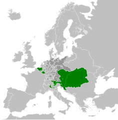
- 2013-04-14T01:33:26Z Alphathon 450x456 (853857 Bytes) == {{int:filedesc}} == {{Information |Description={{en|A blank Map of Europe circa 1789. This map also includes a border for the [[:en:Holy Roman Empire|Holy Roman Empire]]. Since there are so many small German states, they h
Uploaded with derivativeFX
फाइल इतिहास
मिति/समय मा क्लिक गरेर त्यससमयमा यो फाइल कस्तो थियो भनेर हेर्न सकिन्छ ।
| मिति/समय | छोटो चित्र | आकारहरू | प्रयोगकर्ता | टिप्पणी | |
|---|---|---|---|---|---|
| हालको | १३:३९, १७ अक्टोबर २०२१ | | ४५०×४५६ (८५७ किलोबाइटहरू) | Fenn-O-maniC | Fixed the Russo-Swedish border to match the Treaty of Åbo of 1743 |
| ०२:१२, १९ अप्रिल २०१३ |  | ४५०×४५६ (८७७ किलोबाइटहरू) | Alphathon | Style changes | |
| २३:०७, १८ अप्रिल २०१३ |  | ४५०×४५६ (८५६ किलोबाइटहरू) | Alphathon | HRE border | |
| २३:०४, १८ अप्रिल २०१३ |  | ४५०×४५६ (८२० किलोबाइटहरू) | Alphathon | Various fixes | |
| २०:३३, १८ अप्रिल २०१३ |  | ४५०×४५६ (८५३ किलोबाइटहरू) | Alphathon | Fixed Scandinavian borders | |
| ०९:३२, १४ अप्रिल २०१३ |  | ४५०×४५६ (८३९ किलोबाइटहरू) | Alphathon | As main version | |
| ०७:४४, १४ अप्रिल २०१३ |  | ४५०×४५६ (८३१ किलोबाइटहरू) | Alphathon | == {{int:filedesc}} == {{Information |Description={{en|A map of the Habsburg Monarchy circa 1789.}}{{de|Eine Landkarte die Habsburgermonarchie, c. 1989.}} |Source={{Derived from|Europe_1789.svg|disp... |
फाइल प्रयोग
यो फाइलसँग कुनै पनि पृष्ठ जोडिएको छैन।
विश्वव्यापी फाइल प्रयोग
निम्न अन्य विकिहरूमा यस फाइलको प्रयोग:
- cs.wikipedia.org मा उपयोग
- de.wikipedia.org मा उपयोग
- en.wikipedia.org मा उपयोग
- es.wikipedia.org मा उपयोग
- fr.wikipedia.org मा उपयोग
- it.wikipedia.org मा उपयोग
- lt.wikipedia.org मा उपयोग
- pl.wikipedia.org मा उपयोग
- sr.wikipedia.org मा उपयोग
- sv.wikipedia.org मा उपयोग