
चित्र:Kashmir-sat-nasa.jpg
यस पूर्व रुपको आकार: ६०० × ६०० पिक्सल। अरु संकल्पहरू: २४० × २४० पिक्सल • ४८० × ४८० पिक्सल • ६४० × ६४० पिक्सल।
मूल फाइल (६४० × ६४० पिक्सेलहरू, फाइल आकार: ४२८ किलोबाइटहरू, MIME प्रकार: image/jpeg)
| यो विकिमीडिया कमन्सको चित्र हो। त्यहाँ यसको विवरण पृष्ठबाट जानकारी तल देखाइएको छ। कमन्स स्वतन्त्र रूपमा इजाजतपत्र प्राप्त चित्र भण्डार हो। तपाईंले मद्दत गर्न सक्नुहुन्छ। |
सारांश
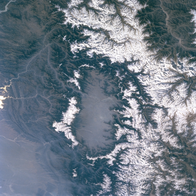
| वर्णन | Kashmir Valley bordered by Karakorm Range in the north, Zanskar Range in the east and Pir Panjal Range in the west and south. |
| मिति | before २ अप्रिल २००९ |
| स्रोत | http://eol.jsc.nasa.gov/sseop/EFS/images.pl?photo=STS066-127-79 |
| लेखक | NASA |
अनुज्ञा प्राप्त गर्दै
| This file is in the public domain in the United States because it was solely created by NASA. NASA copyright policy states that "NASA material is not protected by copyright unless noted". (See Template:PD-USGov, NASA copyright policy page or JPL Image Use Policy.) | ||
 |
Warnings:
|
Original upload log
The original description page was here. All following user names refer to en.wikipedia.
- 2009-04-01 06:02 Doorvery far 640×640× (438485 bytes) Public domain nasa image: http://eol.jsc.nasa.gov/sseop/EFS/images.pl?photo=STS066-127-79
फाइल इतिहास
मिति/समय मा क्लिक गरेर त्यससमयमा यो फाइल कस्तो थियो भनेर हेर्न सकिन्छ ।
| मिति/समय | छोटो चित्र | आकारहरू | प्रयोगकर्ता | टिप्पणी | |
|---|---|---|---|---|---|
| हालको | २१:३०, १७ मे २०११ | | ६४०×६४० (४२८ किलोबाइटहरू) | Woudloper | {{Information |Description={{en|Public domain NASA image: http://eol.jsc.nasa.gov/sseop/EFS/images.pl?photo=STS066-127-79}} |Source=Transferred from [http://en.wikipedia.org en.wikipedia] |Date={{Date|2009|04|01}} (original upload date) |Author=Original u |
फाइल प्रयोग
यस फाइलमा निम्न पृष्ठ जोडिन्छ:
विश्वव्यापी फाइल प्रयोग
निम्न अन्य विकिहरूमा यस फाइलको प्रयोग:
- ar.wikipedia.org मा उपयोग
- be.wikipedia.org मा उपयोग
- bh.wikipedia.org मा उपयोग
- bn.wikipedia.org मा उपयोग
- de.wikipedia.org मा उपयोग
- de.wikivoyage.org मा उपयोग
- dty.wikipedia.org मा उपयोग
- en.wikipedia.org मा उपयोग
- en.wikivoyage.org मा उपयोग
- es.wikipedia.org मा उपयोग
- fa.wikipedia.org मा उपयोग
- frr.wikipedia.org मा उपयोग
- fr.wikipedia.org मा उपयोग
- fr.wikinews.org मा उपयोग
- fr.wikivoyage.org मा उपयोग
- gu.wikipedia.org मा उपयोग
- he.wikipedia.org मा उपयोग
- hi.wikipedia.org मा उपयोग
- id.wikipedia.org मा उपयोग
- ja.wikipedia.org मा उपयोग
- kn.wikipedia.org मा उपयोग
- ko.wikipedia.org मा उपयोग
- ks.wikipedia.org मा उपयोग
- ml.wikipedia.org मा उपयोग
- mr.wikipedia.org मा उपयोग
- ms.wikipedia.org मा उपयोग
- nl.wikipedia.org मा उपयोग
- nn.wikipedia.org मा उपयोग
- os.wikipedia.org मा उपयोग
- pa.wikipedia.org मा उपयोग
- pl.wikipedia.org मा उपयोग
- pnb.wikipedia.org मा उपयोग
- ru.wikipedia.org मा उपयोग
- ru.wikinews.org मा उपयोग
- sa.wikipedia.org मा उपयोग
- simple.wikipedia.org मा उपयोग
- sl.wikipedia.org मा उपयोग
यस फाइलको विश्वव्यापी उपयोगको अधिक जानकारी हेर्नुहोस् ।