
चित्र:Map of current Interstates.svg

Size of this PNG preview of this SVG file: ६८९ × ४३२ पिक्सल. अरु संकल्पहरू: ३२० × २०१ पिक्सल • ६४० × ४०१ पिक्सल • १,०२४ × ६४२ पिक्सल • १,२८० × ८०३ पिक्सल • २,५६० × १,६०५ पिक्सल।
मूल फाइल (SVG फाइल,साधारण ६८९ × ४३२ पिक्सेलहरु, फाइल आकार: ५१८ किलोबाइटहरू)
| यो विकिमीडिया कमन्सको चित्र हो। त्यहाँ यसको विवरण पृष्ठबाट जानकारी तल देखाइएको छ। कमन्स स्वतन्त्र रूपमा इजाजतपत्र प्राप्त चित्र भण्डार हो। तपाईंले मद्दत गर्न सक्नुहुन्छ। |
सारांश
| वर्णन |
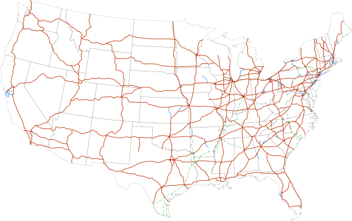
Labels:
One or Two-digit interstates (dark orange line)
Selected three-digit interstates (blue line)
Selected planned interstates (green dashed line) |
| मिति | |
| स्रोत | National Atlas |
| लेखक | SPUI |
अनुज्ञा प्राप्त गर्दै
| This work has been released into the public domain by its author, SPUI. This applies worldwide. In some countries this may not be legally possible; if so: |
| Annotations | This image is annotated: View the annotations at Commons |
फाइल इतिहास
मिति/समय मा क्लिक गरेर त्यससमयमा यो फाइल कस्तो थियो भनेर हेर्न सकिन्छ ।
| मिति/समय | छोटो चित्र | आकारहरू | प्रयोगकर्ता | टिप्पणी | |
|---|---|---|---|---|---|
| हालको | १७:०४, १३ फेब्रुअरी २०१३ | | ६८९×४३२ (५१८ किलोबाइटहरू) | Scott5114 | Add I-49 in Missouri |
| १२:२४, ११ जनवरी २०१३ |  | ६८९×४३२ (५१९ किलोबाइटहरू) | Agricolae | add I-376 rebranding north to I-80, planned I-99 from I-80 to I-86 | |
| १३:१२, २ जुलाई २०११ |  | ६८९×४३२ (४८५ किलोबाइटहरू) | Jkirkuslamont | Changed hues to improve legibility for the colour blind | |
| १०:२१, १० जनवरी २०१० |  | ६८९×४३२ (७५४ किलोबाइटहरू) | Techman224 | Made three-dight Interstates near Atlanta, Georgia blue | |
| ०३:१७, २४ डिसेम्बर २००९ |  | ६८९×४३२ (७५४ किलोबाइटहरू) | Clorox | added I69 | |
| ११:५७, २९ फेब्रुअरी २००८ |  | ६८९×४३२ (७४४ किलोबाइटहरू) | Alex43223 | Updated a couple highways | |
| ०८:२३, २२ जुन २००७ |  | ६८९×४३२ (६८७ किलोबाइटहरू) | Fran Rogers | Reverted to earlier revision | |
| ०८:२२, २२ जुन २००७ |  | ६८९×४३२ (६८७ किलोबाइटहरू) | Fran Rogers | {{spuimap}} Map of the present Interstate Highway System. Base map is [http://www.nationalatlas.gov/printable/images/pdf/reference/genref.pdf] (public domain US Federal Government). *Purple: two-digit *Blue: selected three-digit *Green: selected future ro | |
| २१:५२, १३ जुलाई २००६ |  | ६८९×४३२ (६८७ किलोबाइटहरू) | SPUI~commonswiki | {{spuimap}} |
फाइल प्रयोग
यो फाइलसँग कुनै पनि पृष्ठ जोडिएको छैन।
विश्वव्यापी फाइल प्रयोग
निम्न अन्य विकिहरूमा यस फाइलको प्रयोग:
- an.wikipedia.org मा उपयोग
- ar.wikipedia.org मा उपयोग
- ast.wikipedia.org मा उपयोग
- az.wikipedia.org मा उपयोग
- bg.wikipedia.org मा उपयोग
- bs.wikipedia.org मा उपयोग
- ca.wikipedia.org मा उपयोग
- da.wikipedia.org मा उपयोग
- de.wikipedia.org मा उपयोग
- en.wikipedia.org मा उपयोग
- Economy of the United States
- Transportation in the United States
- List of gaps in Interstate Highways
- List of auxiliary Interstate Highways
- Controlled-access highway
- List of business routes of the Interstate Highway System
- User:Master son/US Roads
- User:Master son/US Roads/MTF
- Driving in the United States
- Trucking industry in the United States
- 1956 in the United States
- List of transport megaprojects
- User:Stephen100002/sandbox
- User:Vigneshdm1990/sandbox
- User:44Nifty/sandbox
- User:XanUltra
- Transportation policy of the United States
- Talk:United States/Archive 102
- Portal:Transport/Highway media
- Wikipedia talk:External links/Archive 42
- Wikipedia:Village pump (technical)/Archive 208
- en.wikibooks.org मा उपयोग
- eo.wikipedia.org मा उपयोग
- es.wikipedia.org मा उपयोग
- et.wikipedia.org मा उपयोग
- eu.wikipedia.org मा उपयोग
- fa.wikipedia.org मा उपयोग
- fi.wikipedia.org मा उपयोग
यस फाइलको विश्वव्यापी उपयोगको अधिक जानकारी हेर्नुहोस् ।