
चित्र:Schengenzone.svg

Size of this PNG preview of this SVG file: ५६० × ५९९ पिक्सल. अरु संकल्पहरू: २२४ × २४० पिक्सल • ४४९ × ४८० पिक्सल • ७१८ × ७६८ पिक्सल • ९५७ × १,०२४ पिक्सल • १,९१४ × २,०४८ पिक्सल • ६४५ × ६९० पिक्सल।
मूल फाइल (SVG फाइल,साधारण ६४५ × ६९० पिक्सेलहरु, फाइल आकार: ३५७ किलोबाइटहरू)
| यो विकिमीडिया कमन्सको चित्र हो। त्यहाँ यसको विवरण पृष्ठबाट जानकारी तल देखाइएको छ। कमन्स स्वतन्त्र रूपमा इजाजतपत्र प्राप्त चित्र भण्डार हो। तपाईंले मद्दत गर्न सक्नुहुन्छ। |
सारांश
| वर्णन |
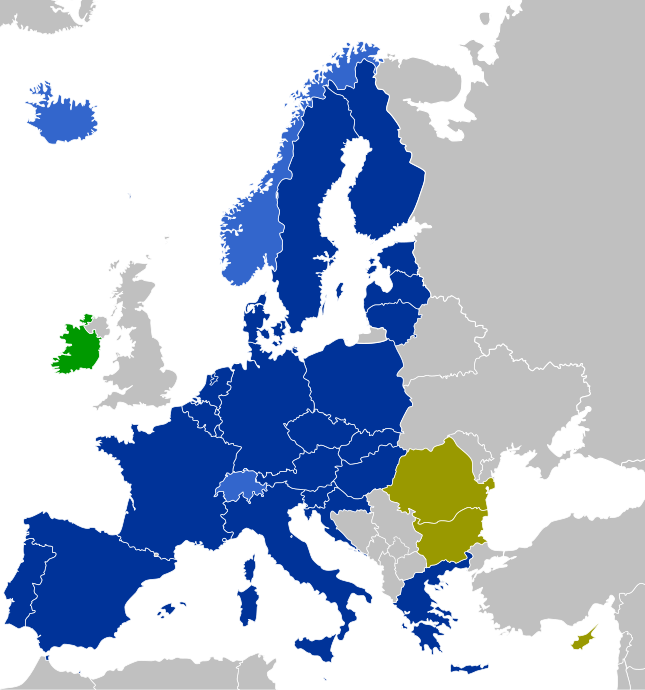
Countries which have implemented the Schengen Agreement Dark Blue: EU member states
Light Blue: Non-EU member states
Purple: EU member states with consequent controls on their land borders (planned to be dropped later)
Olive: EU member states which have not implemented the Schengen Agreement yet (without opt-out)
Green: EU member states which apply only some Schengen laws (with opt-out) |
| मिति | |
| स्रोत | मेरो आफ्नै कार्य |
| लेखक | CrazyPhunk |
| अरु संस्करणहरू | There is similar map Schengen Area participation.svg existing. |
| SVG genesis |
अनुज्ञा प्राप्त गर्दै
| I, the copyright holder of this work, release this work into the public domain. This applies worldwide. In some countries this may not be legally possible; if so: I grant anyone the right to use this work for any purpose, without any conditions, unless such conditions are required by law. |
फाइल इतिहास
मिति/समय मा क्लिक गरेर त्यससमयमा यो फाइल कस्तो थियो भनेर हेर्न सकिन्छ ।
| मिति/समय | छोटो चित्र | आकारहरू | प्रयोगकर्ता | टिप्पणी | |
|---|---|---|---|---|---|
| हालको | ०१:३६, १ जुन २०२४ | | ६४५×६९० (३५७ किलोबाइटहरू) | Stefan040780 | Update BG + RO, colours fixed, Malta with circle |
| १८:४६, २ जनवरी २०२३ |  | ६४५×६९० (३५८ किलोबाइटहरू) | Iktsokh | Correction of borders | |
| ०६:२८, १ जनवरी २०२३ |  | ६४५×६९० (४७८ किलोबाइटहरू) | Kamran.nef | Added Croatia | |
| ०१:०७, १० जुन २०२१ |  | ६४५×६९० (४७७ किलोबाइटहरू) | Geo.smart | Reverted to version as of 13:12, 1 January 2021 (UTC) UK is a part of neither EU nor the Schengenzone | |
| ००:११, ३ जनवरी २०२१ |  | ६४५×६९० (४७७ किलोबाइटहरू) | Opihuck | Reverted to version as of 23:02, 4 February 2020 (UTC) | |
| १८:५७, १ जनवरी २०२१ |  | ६४५×६९० (४७७ किलोबाइटहरू) | Ärrännä | Reverted to version as of 01:32, 1 February 2020 (UTC) because now United Kingdom is not anymore part of EU | |
| ०४:४७, ५ फेब्रुअरी २०२० |  | ६४५×६९० (४७७ किलोबाइटहरू) | Opihuck | Reverted to version as of 21:43, 20 February 2017 (UTC) - GB und IRL continue to be associated at least until end of 2020 | |
| ०७:१७, १ फेब्रुअरी २०२० |  | ६४५×६९० (४७७ किलोबाइटहरू) | Tohaomg | Brexit | |
| ०३:२८, २१ फेब्रुअरी २०१७ |  | ६४५×६९० (४७७ किलोबाइटहरू) | Nablicus | lakes removed | |
| १८:०८, २१ अगस्ट २०१५ |  | ६४५×६९० (५२६ किलोबाइटहरू) | DaB. | Lakes, no Boarders. |
फाइल प्रयोग
यस फाइलमा निम्न पृष्ठ जोडिन्छ:
विश्वव्यापी फाइल प्रयोग
निम्न अन्य विकिहरूमा यस फाइलको प्रयोग:
- af.wikipedia.org मा उपयोग
- als.wikipedia.org मा उपयोग
- ar.wikipedia.org मा उपयोग
- arz.wikipedia.org मा उपयोग
- bg.wikipedia.org मा उपयोग
- bn.wikipedia.org मा उपयोग
- ca.wikipedia.org मा उपयोग
- cs.wikipedia.org मा उपयोग
- de.wikipedia.org मा उपयोग
- Schengener Abkommen
- Schengener Informationssystem
- Dezember 2008
- Dezember 2011
- Wikipedia:Kartenwerkstatt/Archiv/2011-05
- Verordnung (EG) Nr. 539/2001 (EU-Visum-Verordnung)
- Verordnung (EU) 2016/399 (Schengener Grenzkodex)
- Diskussion:Flüchtlingskrise in Europa 2015/2016/Archiv/2
- Verordnung (EG) Nr. 810/2009 (Visakodex)
- Benutzer:Tmid
- Portal:Migration und Integration/Artikel des Monats
- Einreise-/Ausreisesystem
- Europäisches Reiseinformations- und ‑genehmigungssystem
- Benutzer:Opihuck/Verordnung (EG) Nr. 539/2001 (EU-Visum-Verordnung)
- Extrempunkte der Europäischen Union
- Benutzer:Kpfiwa/Spielwiese/Test
- Benutzer:Valo139
- Benutzer:Wandelndes Lexikon/alt
- Benutzer:Wandelndes Lexikon/Babel
- Benutzer:Wandelndes Lexikon/Babel/Schengen-Raum
- Benutzer:Wandelndes Lexikon/Babel-Block/Herkunft
- Benutzer:Wandelndes Lexikon/Babel-Block
- Benutzer:Wandelndes Lexikon
- de.wikibooks.org मा उपयोग
- de.wikinews.org मा उपयोग
- en.wikipedia.org मा उपयोग
- en.wikibooks.org मा उपयोग
- en.wikinews.org मा उपयोग
- es.wikipedia.org मा उपयोग
- eu.wikipedia.org मा उपयोग
- fi.wikipedia.org मा उपयोग
- fr.wikipedia.org मा उपयोग
यस फाइलको विश्वव्यापी उपयोगको अधिक जानकारी हेर्नुहोस् ।