
चित्र:China India eastern border 88.jpg

यस पूर्व रुपको आकार: ४८३ × ६०० पिक्सल। अरु संकल्पहरू: १९३ × २४० पिक्सल • ३८७ × ४८० पिक्सल • १,०१९ × १,२६५ पिक्सल।
मूल फाइल (१,०१९ × १,२६५ पिक्सेलहरू, फाइल आकार: २९७ किलोबाइटहरू, MIME प्रकार: image/jpeg)
| यो विकिमीडिया कमन्सको चित्र हो। त्यहाँ यसको विवरण पृष्ठबाट जानकारी तल देखाइएको छ। कमन्स स्वतन्त्र रूपमा इजाजतपत्र प्राप्त चित्र भण्डार हो। तपाईंले मद्दत गर्न सक्नुहुन्छ। |
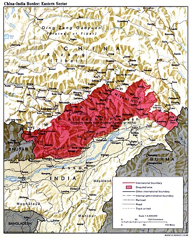
| वर्णन | China India eastern border depicting disputed areas in this sector including NEFA. | |||
| मिति | ||||
| स्रोत | http://www.lib.utexas.edu/maps/middle_east_and_asia/china_india_e_border_88.jpg | |||
| लेखक | Central Intelligence Agency | |||
| अनुमति (यो फाइल पुनप्रयोग गर्न) |
|
|||
| अरु संस्करणहरू |
 |

| Annotations | This image is annotated: View the annotations at Commons |
फाइल इतिहास
मिति/समय मा क्लिक गरेर त्यससमयमा यो फाइल कस्तो थियो भनेर हेर्न सकिन्छ ।
| मिति/समय | छोटो चित्र | आकारहरू | प्रयोगकर्ता | टिप्पणी | |
|---|---|---|---|---|---|
| हालको | १०:४४, २ अप्रिल २००७ | | १,०१९×१,२६५ (२९७ किलोबाइटहरू) | Yuje | China India eastern border depicting disputed areas in this sector including NEFA. Taken from [http://www.lib.utexas.edu/maps/middle_east_and_asia/china_indiae_border_88.jpg] |
फाइल प्रयोग
यस फाइलमा निम्न पृष्ठ जोडिन्छ:
विश्वव्यापी फाइल प्रयोग
निम्न अन्य विकिहरूमा यस फाइलको प्रयोग:
- as.wikipedia.org मा उपयोग
- bn.wikipedia.org मा उपयोग
- cs.wikipedia.org मा उपयोग
- de.wikipedia.org मा उपयोग
- en.wikipedia.org मा उपयोग
- es.wikipedia.org मा उपयोग
- fa.wikipedia.org मा उपयोग
- fr.wikipedia.org मा उपयोग
- gu.wikipedia.org मा उपयोग
- he.wikipedia.org मा उपयोग
- hi.wikipedia.org मा उपयोग
- hr.wikipedia.org मा उपयोग
- hu.wikipedia.org मा उपयोग
- id.wikipedia.org मा उपयोग
- it.wikipedia.org मा उपयोग
- ja.wikipedia.org मा उपयोग
- kn.wikipedia.org मा उपयोग
- ko.wikipedia.org मा उपयोग
- ky.wikipedia.org मा उपयोग
- lt.wikipedia.org मा उपयोग
- ms.wikipedia.org मा उपयोग
- nl.wikipedia.org मा उपयोग
- pa.wikipedia.org मा उपयोग
- pl.wikipedia.org मा उपयोग
- pnb.wikipedia.org मा उपयोग
- pt.wikipedia.org मा उपयोग
यस फाइलको विश्वव्यापी उपयोगको अधिक जानकारी हेर्नुहोस् ।