
चित्र:Communist countries.svg

Size of this PNG preview of this SVG file: ८०० × ४०९ पिक्सल. अरु संकल्पहरू: ३२० × १६४ पिक्सल • ६४० × ३२७ पिक्सल • १,०२४ × ५२४ पिक्सल • १,२८० × ६५५ पिक्सल • २,५६० × १,३१० पिक्सल • ८६० × ४४० पिक्सल।
मूल फाइल (SVG फाइल,साधारण ८६० × ४४० पिक्सेलहरु, फाइल आकार: १.१८ मेगाबाइटहरू)
| यो विकिमीडिया कमन्सको चित्र हो। त्यहाँ यसको विवरण पृष्ठबाट जानकारी तल देखाइएको छ। कमन्स स्वतन्त्र रूपमा इजाजतपत्र प्राप्त चित्र भण्डार हो। तपाईंले मद्दत गर्न सक्नुहुन्छ। |
सारांश
| वर्णन |
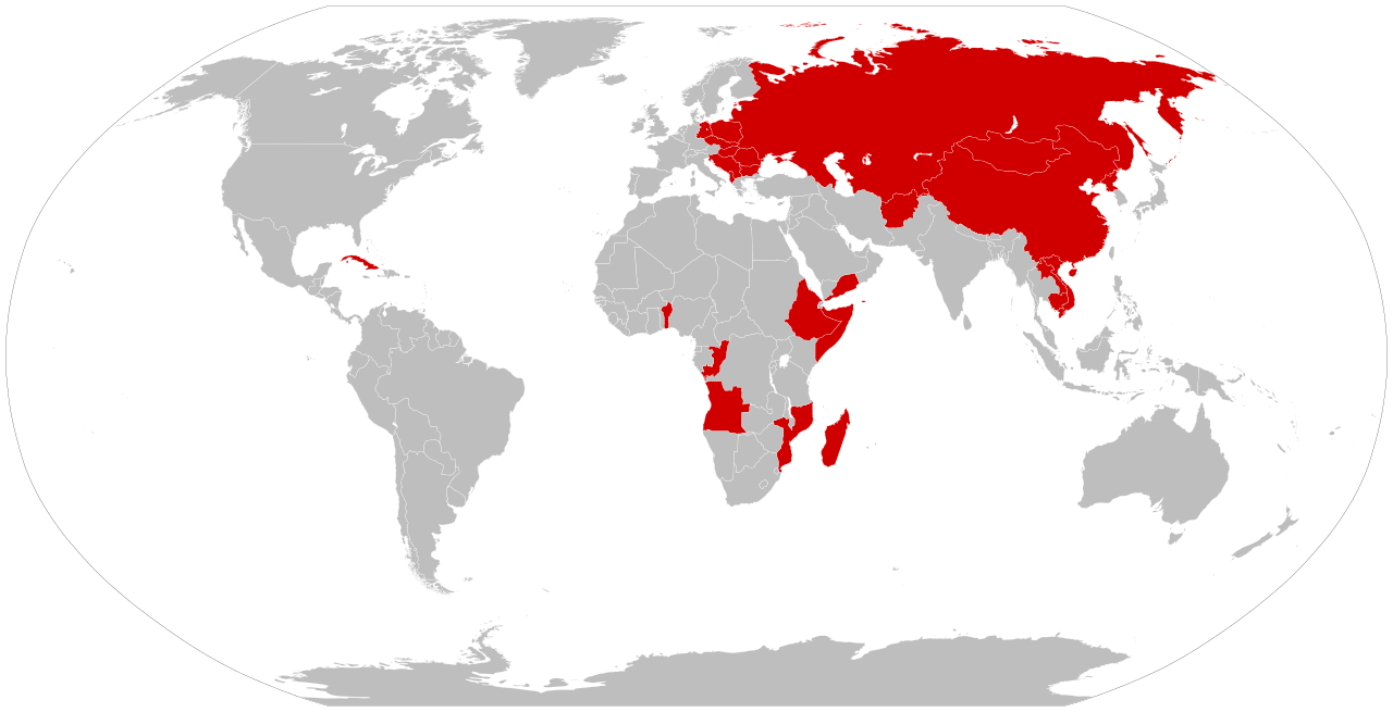
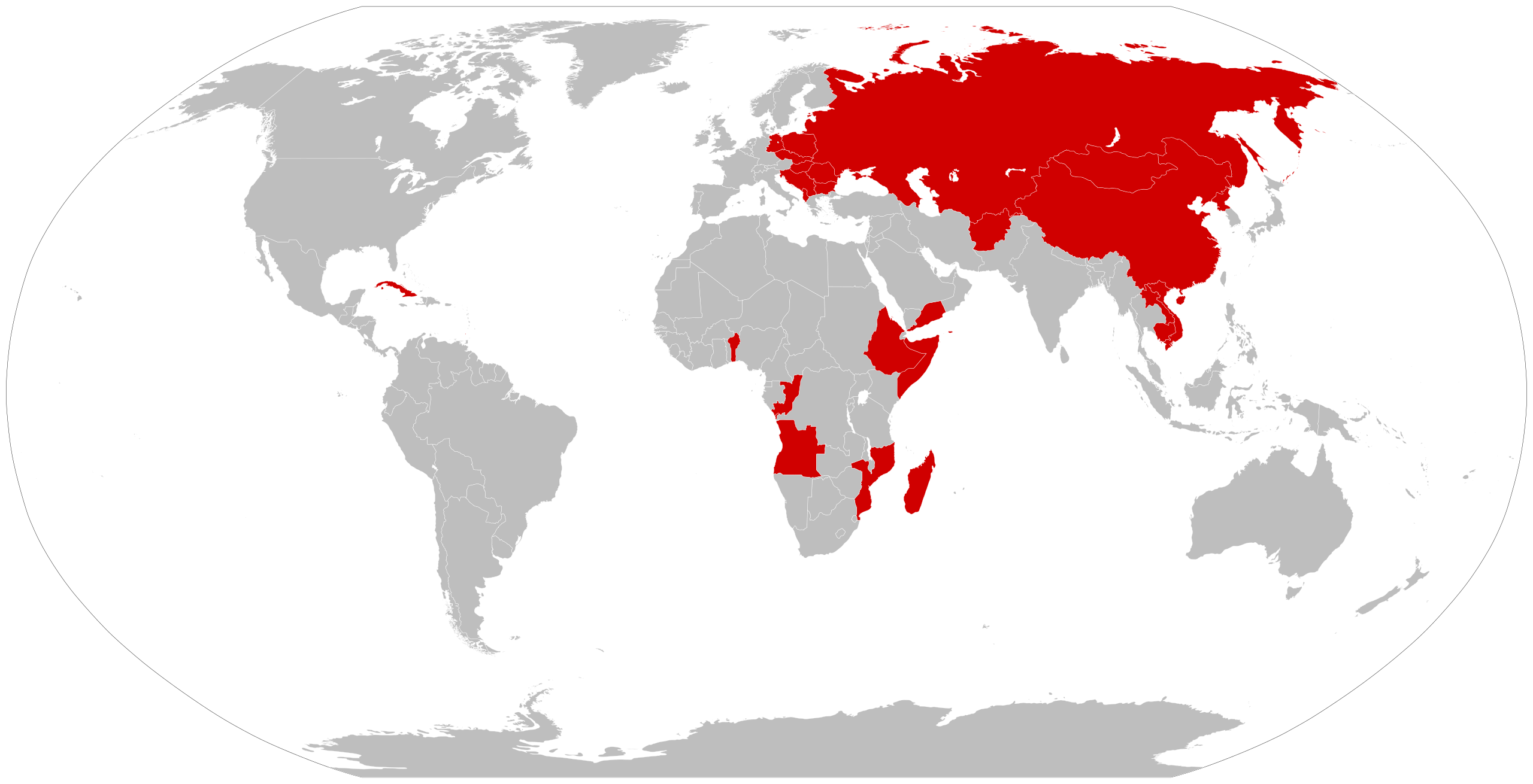
العربية: خريطة قديمة (باستخدام الحدود الحالية) تُظهر الدول التي حُكمت بالماركسية اللينينية ذات حزب واحد في مرحلة ما من تاريخها كانت جميع الأمم الملونة أعلاه تحت سيطرة الشيوعيين الماركسيين اللينينيين في نفس الوقت.
English: An anachronous map of countries (using present-day borders) that have been ruled by a one-party Marxist-Leninist state at some point in their history.
By the time of the 1979-1983 Communist Grenada, all the colored nations above were simultaneously Communist-controlled. |
| मिति | |
| स्रोत | मेरो आफ्नै कार्य |
| लेखक | Smurfy |
| अरु संस्करणहरू |
Derivative works of this file: Communist countries.svg  |
| SVG genesis | This vector image was created with Inkscape, or with something else. |
अनुज्ञा प्राप्त गर्दै
| I, the copyright holder of this work, release this work into the public domain. This applies worldwide. In some countries this may not be legally possible; if so: I grant anyone the right to use this work for any purpose, without any conditions, unless such conditions are required by law. |
फाइल इतिहास
मिति/समय मा क्लिक गरेर त्यससमयमा यो फाइल कस्तो थियो भनेर हेर्न सकिन्छ ।
| मिति/समय | छोटो चित्र | आकारहरू | प्रयोगकर्ता | टिप्पणी | |
|---|---|---|---|---|---|
| हालको | ००:०३, १४ अप्रिल २०२४ | | ८६०×४४० (१.१८ मेगाबाइटहरू) | Campista2015 | Reverted to version as of 13:08, 22 November 2017 (UTC) |
| २३:१९, २० डिसेम्बर २०१७ |  | ८६०×४४० (१.१८ मेगाबाइटहरू) | Jdx | Reverted to version as of 02:34, 22 October 2016 (UTC) | |
| १८:५३, २२ नोभेम्बर २०१७ |  | ८६०×४४० (१.१८ मेगाबाइटहरू) | Ameet12345 | Reverted to version as of 12:55, 22 November 2017 (UTC) | |
| १८:५१, २२ नोभेम्बर २०१७ |  | ९४०×४७७ (१.५५ मेगाबाइटहरू) | Ameet12345 | Reverted to version as of 14:50, 18 July 2010 (UTC) | |
| १८:४०, २२ नोभेम्बर २०१७ |  | ८६०×४४० (१.१८ मेगाबाइटहरू) | Ameet12345 | Reverted to version as of 22:37, 19 July 2010 (UTC) | |
| ०८:१९, २२ अक्टोबर २०१६ |  | ८६०×४४० (१.१८ मेगाबाइटहरू) | TriadicRelation98 | Updated to add Madagascar and Grenada | |
| ०२:०९, १९ सेप्टेम्बर २०११ |  | ८६०×४४० (१.१८ मेगाबाइटहरू) | Fry1989 | Reverted to version as of 22:37, 19 July 2010 | |
| २२:५४, १८ सेप्टेम्बर २०११ | छोटो चित्र नभएको | ०×० (१५.४१ मेगाबाइटहरू) | JJ Georges | added Madagascar (included to the list by several scholars) and Grenada | |
| ०४:२२, २० जुलाई २०१० |  | ८६०×४४० (१.१८ मेगाबाइटहरू) | Beao | Removed border. | |
| २०:३५, १८ जुलाई २०१० |  | ९४०×४७७ (१.५५ मेगाबाइटहरू) | Smurfy | {{Information |Description=An anachronous map of countries (using present-day borders) that have been ruled by a one-party Marxist-Leninist state at some point in their history. By the time of the 1979-1983 [ |
फाइल प्रयोग
यस फाइलमा निम्न पृष्ठ जोडिन्छ:
विश्वव्यापी फाइल प्रयोग
निम्न अन्य विकिहरूमा यस फाइलको प्रयोग:
- am.wikipedia.org मा उपयोग
- ar.wikipedia.org मा उपयोग
- az.wikipedia.org मा उपयोग
- bh.wikipedia.org मा उपयोग
- ca.wikipedia.org मा उपयोग
- ckb.wikipedia.org मा उपयोग
- cs.wikipedia.org मा उपयोग
- de.wikipedia.org मा उपयोग
- en.wikipedia.org मा उपयोग
- eo.wikipedia.org मा उपयोग
- it.wikipedia.org मा उपयोग
- ko.wikipedia.org मा उपयोग
- mk.wikipedia.org मा उपयोग
- mr.wikipedia.org मा उपयोग
- oc.wikipedia.org मा उपयोग
- simple.wikipedia.org मा उपयोग
- sq.wikipedia.org मा उपयोग
- sr.wikipedia.org मा उपयोग
- te.wikipedia.org मा उपयोग
- th.wikipedia.org मा उपयोग
- uk.wikipedia.org मा उपयोग
- vi.wikipedia.org मा उपयोग
- zh-yue.wikipedia.org मा उपयोग
- zh.wikipedia.org मा उपयोग