
चित्र:Mauritius-CIA WFB Map.png
उच्च रिजोल्युशन अनुपलब्ध
Mauritius-CIA_WFB_Map.png (३३० × ३५५ पिक्सेलहरू, फाइल आकार: ९ किलोबाइटहरू, MIME प्रकार: image/png)
| यो विकिमीडिया कमन्सको चित्र हो। त्यहाँ यसको विवरण पृष्ठबाट जानकारी तल देखाइएको छ। कमन्स स्वतन्त्र रूपमा इजाजतपत्र प्राप्त चित्र भण्डार हो। तपाईंले मद्दत गर्न सक्नुहुन्छ। |
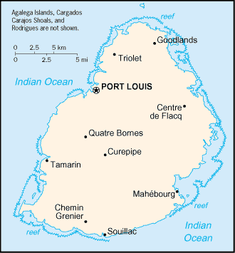
| वर्णन | Map of Mauritius showing towns. | |||
| मिति | ||||
| स्रोत | CIA, The World Factbook, 2004 | |||
| लेखक | CIA | |||
| अनुमति (यो फाइल पुनप्रयोग गर्न) |
|


|
This locator map image could be re-created using vector graphics as an SVG file. This has several advantages; see Commons:Media for cleanup for more information. If an SVG form of this image is available, please upload it and afterwards replace this template with
{{vector version available|new image name}}.
It is recommended to name the SVG file “Mauritius-CIA WFB Map.svg”—then the template Vector version available (or Vva) does not need the new image name parameter. |
फाइल इतिहास
मिति/समय मा क्लिक गरेर त्यससमयमा यो फाइल कस्तो थियो भनेर हेर्न सकिन्छ ।
| मिति/समय | छोटो चित्र | आकारहरू | प्रयोगकर्ता | टिप्पणी | |
|---|---|---|---|---|---|
| हालको | १५:०१, २७ मार्च २००५ | | ३३०×३५५ (९ किलोबाइटहरू) | Wolfman~commonswiki | {{CIA-map}} |
फाइल प्रयोग
यस फाइलमा निम्न पृष्ठ जोडिन्छ:
विश्वव्यापी फाइल प्रयोग
निम्न अन्य विकिहरूमा यस फाइलको प्रयोग:
- als.wikipedia.org मा उपयोग
- arz.wikipedia.org मा उपयोग
- be-tarask.wikipedia.org मा उपयोग
- be.wikipedia.org मा उपयोग
- br.wikipedia.org मा उपयोग
- el.wikipedia.org मा उपयोग
- en.wikisource.org मा उपयोग
- eo.wikipedia.org मा उपयोग
- es.wikipedia.org मा उपयोग
- fi.wikipedia.org मा उपयोग
- fo.wikipedia.org मा उपयोग
- fy.wikipedia.org मा उपयोग
- gd.wikipedia.org मा उपयोग
- he.wikipedia.org मा उपयोग
- hr.wikipedia.org मा उपयोग
- ht.wikipedia.org मा उपयोग
- hu.wikipedia.org मा उपयोग
- hu.wiktionary.org मा उपयोग
- ia.wikipedia.org मा उपयोग
- id.wikipedia.org मा उपयोग
- io.wikipedia.org मा उपयोग
- ja.wikipedia.org मा उपयोग
- kn.wikipedia.org मा उपयोग
- la.wikipedia.org मा उपयोग
- lt.wikipedia.org मा उपयोग
- lt.wiktionary.org मा उपयोग
- mr.wikipedia.org मा उपयोग
- ms.wikipedia.org मा उपयोग
- nds-nl.wikipedia.org मा उपयोग
- nl.wikipedia.org मा उपयोग
- nn.wikipedia.org मा उपयोग
- no.wikipedia.org मा उपयोग
- rue.wikipedia.org मा उपयोग
- ru.wikipedia.org मा उपयोग
- sg.wikipedia.org मा उपयोग
- sg.wiktionary.org मा उपयोग
- sh.wikipedia.org मा उपयोग
- sq.wikipedia.org मा उपयोग
- sr.wikipedia.org मा उपयोग
- sv.wikipedia.org मा उपयोग
- sw.wikipedia.org मा उपयोग
- th.wikipedia.org मा उपयोग
यस फाइलको विश्वव्यापी उपयोगको अधिक जानकारी हेर्नुहोस् ।