
चित्र:Proposed states and union territories of India.svg

Size of this PNG preview of this SVG file: ५३१ × ६०० पिक्सल. अरु संकल्पहरू: २१२ × २४० पिक्सल • ४२५ × ४८० पिक्सल • ६८० × ७६८ पिक्सल • ९०६ × १,०२४ पिक्सल • १,८१३ × २,०४८ पिक्सल • १,६४३ × १,८५६ पिक्सल।
मूल फाइल (SVG फाइल,साधारण १,६४३ × १,८५६ पिक्सेलहरु, फाइल आकार: ८०५ किलोबाइटहरू)
| यो विकिमीडिया कमन्सको चित्र हो। त्यहाँ यसको विवरण पृष्ठबाट जानकारी तल देखाइएको छ। कमन्स स्वतन्त्र रूपमा इजाजतपत्र प्राप्त चित्र भण्डार हो। तपाईंले मद्दत गर्न सक्नुहुन्छ। |
सारांश
| वर्णन |
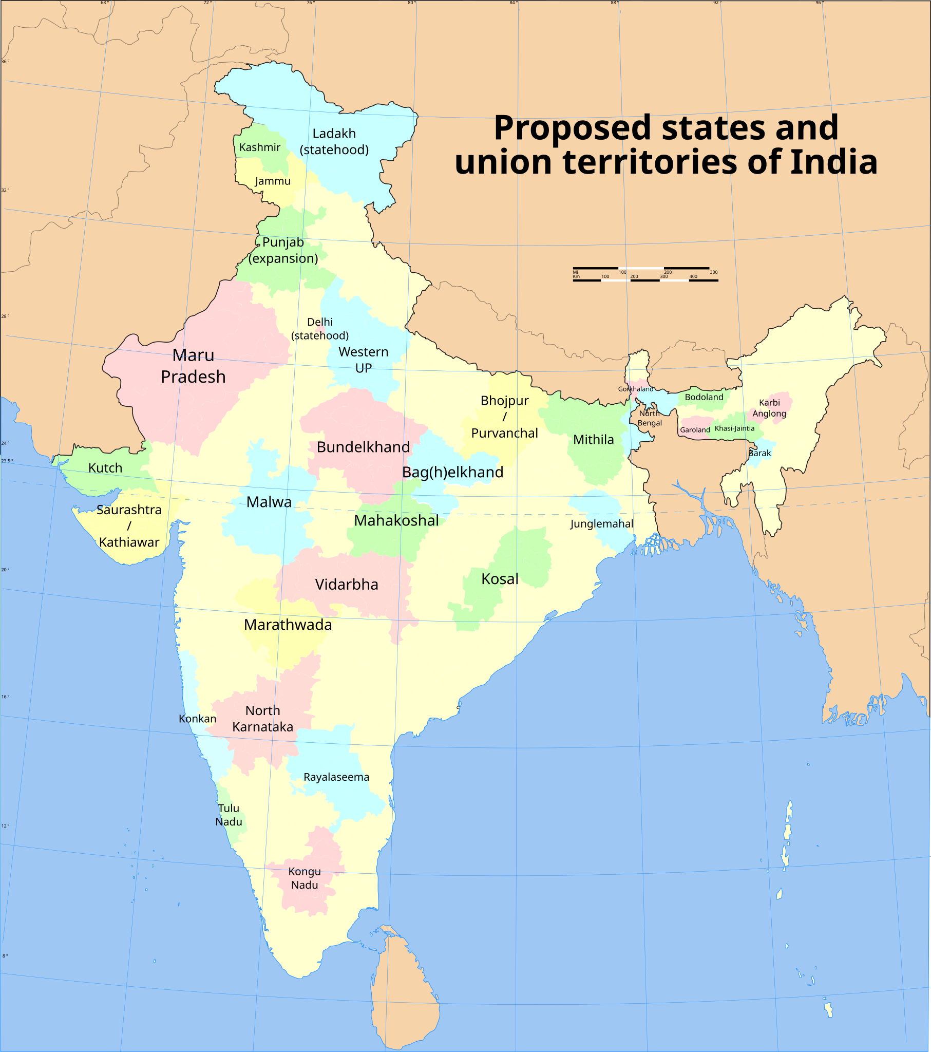
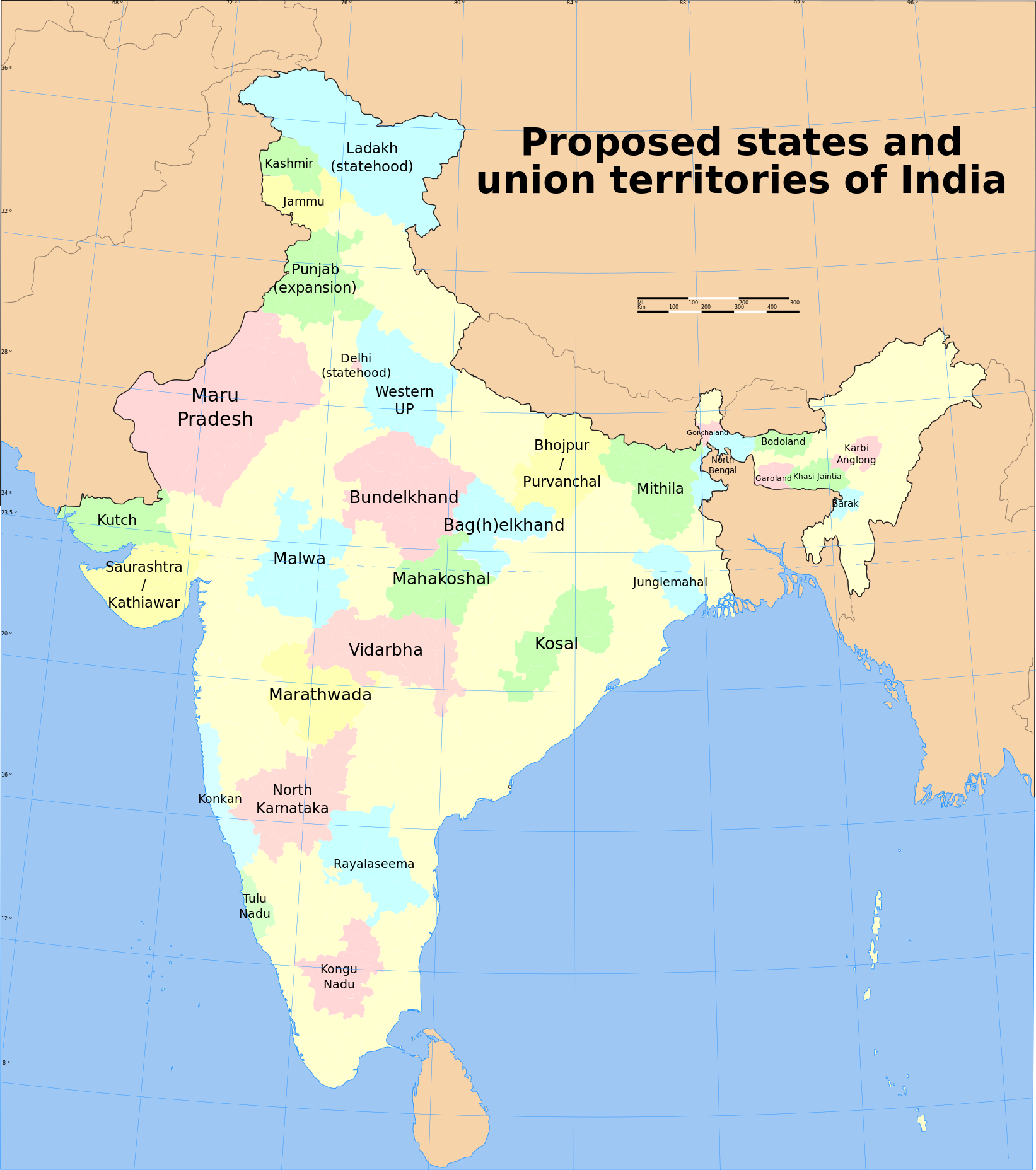
English: Map of proposed states and union territories of India, as of July 2023. It is based on the reliable data from English Wikipedia. NB: Some of the proposed states have multiple proposed names. Minor proposals (Panun Kashmir, Gondwana) are not included. |
| मिति | |
| स्रोत |
This file was derived from: India district map (claimed).svg |
| लेखक | Sbb1413 |
.svg)
अनुज्ञा प्राप्त गर्दै
यो फाइल क्रिएटिभ कमन्स एट्रिब्युसन-सेयर एलाइक ३.० अनपोर्टेड लाइसेन्स अनुसारको अनुमति प्राप्त छ।
- तपाईं स्वतन्त्र हुनुहुन्छ :
- साझेदारी गर्नुहाेस् – रचनालाई कपी, वितरित तथा संचारित गर्नको लागि
- रिमिक्स गर्नको लागि – काम अनुकूलित गर्नको लागि
- निम्नलिखित कारणहरूको अन्तर्गत:
- एट्रिब्युसन – तपाईंले रचनाको श्रेय अनुमतिपत्रकर्ता अथवा लेखकले बताएको माध्यमले दिनु पर्नेछ (तर यस प्रकार हैन, जसमा लागोस् की उ तपाईंलाई अथवा तपाईंको रचनाको प्रयोगलाई समर्थन गर्छन्)।
- शेयर अलाइक – यदि तपाई यस रचनामा कुनै परिवर्तन अथवा संसोधन गर्नुहुन्छ या यसमा आधारित केही रचना गर्नुहुन्छ भने तपाई निष्कर्ष स्वरूप बनेको रचनालाई मात्र यहाँ अथवा यसको समान कुनै अनिमति पत्र अन्तर्गत वितरित गर्न सक्नुहुन्छ।
फाइल इतिहास
मिति/समय मा क्लिक गरेर त्यससमयमा यो फाइल कस्तो थियो भनेर हेर्न सकिन्छ ।
| मिति/समय | छोटो चित्र | आकारहरू | प्रयोगकर्ता | टिप्पणी | |
|---|---|---|---|---|---|
| हालको | १०:५७, ५ जुलाई २०२३ | | १,६४३×१,८५६ (८०५ किलोबाइटहरू) | Sbb1413 | added title |
| २०:५५, १४ अप्रिल २०२३ |  | १,६४३×१,८५६ (८०४ किलोबाइटहरू) | Sbb1413 | larger font size | |
| २०:५१, १४ अप्रिल २०२३ |  | १,६४३×१,८५६ (८०४ किलोबाइटहरू) | Sbb1413 | Junglemahal | |
| २०:४९, १४ अप्रिल २०२३ |  | १,६४३×१,८५६ (८०४ किलोबाइटहरू) | Sbb1413 | New map, new state proposals. | |
| १४:०३, ३ फेब्रुअरी २०२१ |  | १,५७४×१,७३८ (९७७ किलोबाइटहरू) | Sbb1413 | Added a note that Vindya Pradesh is proposed to combine Bundelkhand and Bag(h)elkhand. | |
| १४:००, ३ फेब्रुअरी २०२१ |  | १,५७४×१,७३८ (९७७ किलोबाइटहरू) | Sbb1413 | Poonch district is part of the proposed Jammu state, which consist of all the districts that are not situated in the Kashmir Valley. | |
| १४:१४, २ फेब्रुअरी २०२१ |  | १,५७४×१,७३८ (९७७ किलोबाइटहरू) | Sbb1413 | Bhojpur and Purvanchal proposals differ. While the Bhojpur proposal include the frontier districts of both UP and Bihar, the Purvanchal proposal only include the frontier districts of UP. | |
| १३:५९, २ फेब्रुअरी २०२१ |  | १,५७४×१,७३८ (९७७ किलोबाइटहरू) | Sbb1413 | Uploaded a work by {{U|Soumya-8974}} (derived work) from File:India map blank.svg with UploadWizard |
फाइल प्रयोग
यस फाइलमा निम्न पृष्ठ जोडिन्छ:
विश्वव्यापी फाइल प्रयोग
निम्न अन्य विकिहरूमा यस फाइलको प्रयोग:
- bn.wikipedia.org मा उपयोग
- en.wikipedia.org मा उपयोग