
चित्र:Countries driving on the left or right.svg

Size of this PNG preview of this SVG file: ८०० × ४०६ पिक्सल. अरु संकल्पहरू: ३२० × १६२ पिक्सल • ६४० × ३२५ पिक्सल • १,०२४ × ५२० पिक्सल • १,२८० × ६५० पिक्सल • २,५६० × १,३०० पिक्सल • २,७५४ × १,३९८ पिक्सल।
मूल फाइल (SVG फाइल,साधारण २,७५४ × १,३९८ पिक्सेलहरु, फाइल आकार: १.१ मेगाबाइटहरू)
| यो विकिमीडिया कमन्सको चित्र हो। त्यहाँ यसको विवरण पृष्ठबाट जानकारी तल देखाइएको छ। कमन्स स्वतन्त्र रूपमा इजाजतपत्र प्राप्त चित्र भण्डार हो। तपाईंले मद्दत गर्न सक्नुहुन्छ। |
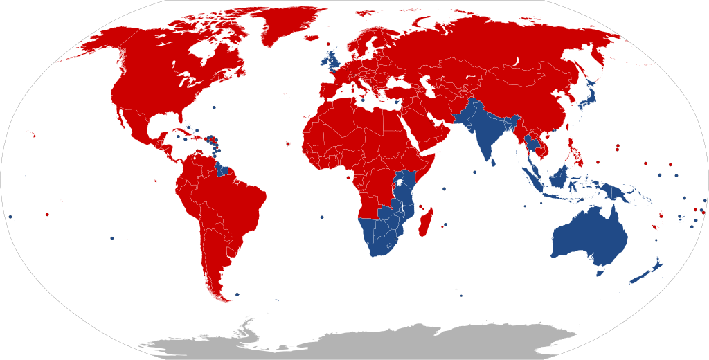
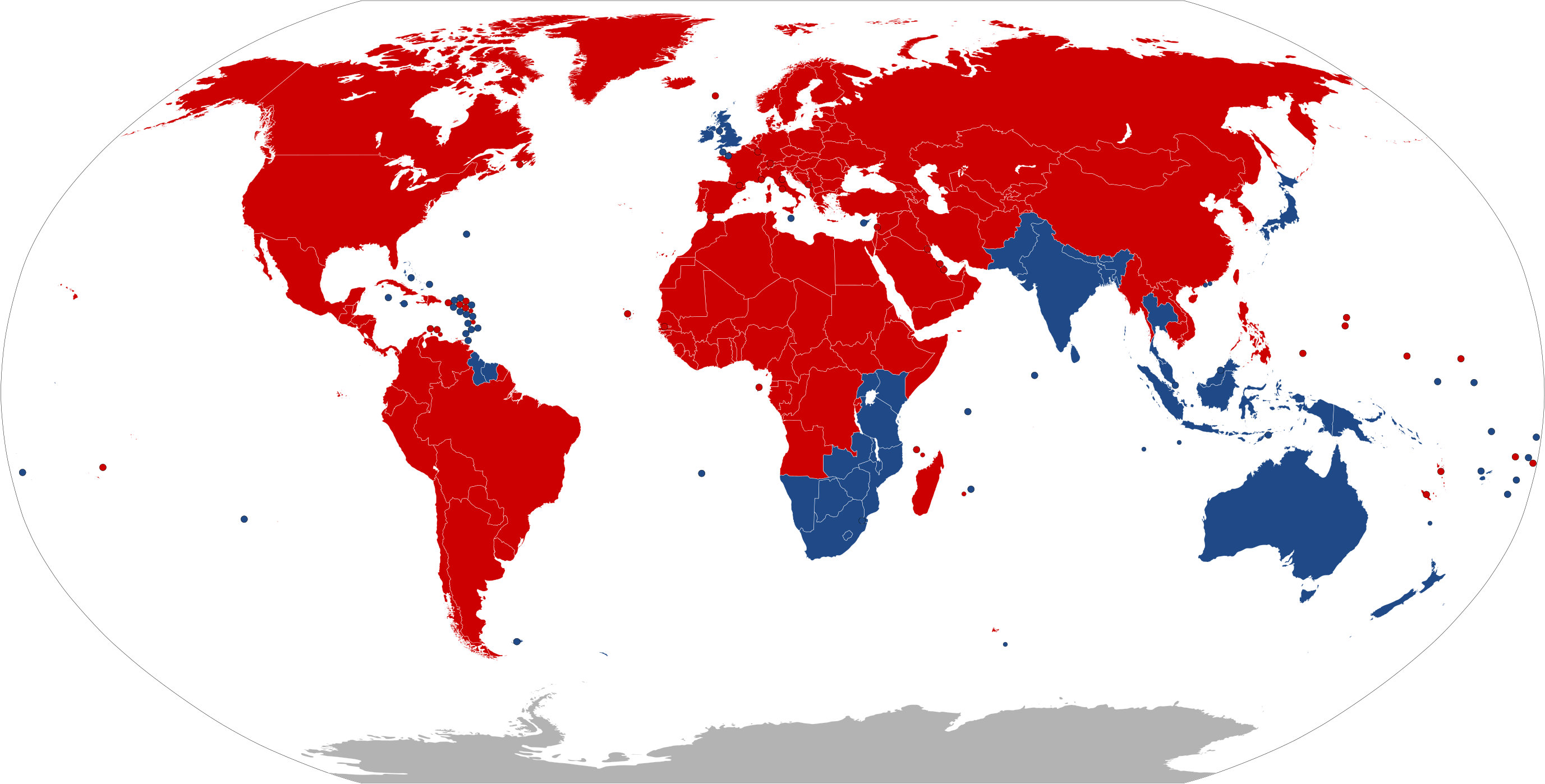
| Colour | Explanation | |
|---|---|---|
| ↓↑ | Drives on right | |
| ↑↓ | Drives on left | |
| ? | No Information |
| वर्णन |
Deutsch: Die Karte zeigt, in welchen Ländern der Erde Rechtsverkehr und in welchen Linksverkehr besteht.
Bosanski: Mapa pokazuje u kojim državama se vozi na desnoj strani ulice, a u kojim se vozi na lijevoj strani.
Català: Mapa que mostra en quins països es conduïx pel costat dret de la carretera, i en quins es conduïx pel costat esquerre.
English: A map indicating which countries drive on the right side of the road, and which drive on the left side.
Esperanto: Mapo indikanta, en kiuj landoj oni veturas sur la dekstra flanko de la strato, kaj en kiuj oni veturas sur la maldekstra flanko.
Español: Mapa que indica en cuáles países se maneja por el lado derecho o el lado izquierdo de la calle.
Bahasa Indonesia: Peta yang menunjukkan negara mana yang mengemudi di sisi kanan jalan, dan mana yang mengemudi di sisi kiri.
Íslenska: Kort sem sýnir hver lönd nota hægri umferð, og hver nota vinstri umferð.
Italiano: Mappa che indica in quali paesi si guida sul lato destro e in quali sul lato sinistro della strada.
日本語: 道路の右側を通行する国か左側を通行する国かを示した地図。
Nederlands: Deze kaart geeft aan in welke landen ter Wereld er Rechts en in welke er Links gereden wordt.
Polski: Mapa pokazująca, w jakich krajach jeździ się po prawej stronie drogi, a w których po lewej.
Русский: Карта с указанием, в каких странах ездят по правой стороне дороги и в каких ездят по левой стороне.
Türkçe: Trafiğin yolun sağ tarafından ve sol tarafından aktığını belirten ülkelerin haritası.
中文:显示世界上靠右行驶和靠左行驶的国家。 |
||
| मिति | |||
| स्रोत |
Created by bdesham in Inkscape from BlankMap-World6.svg, using information from Sens de circulation.png. This W3C-unspecified vector image was created with Inkscape . |
||
| लेखक | Benjamin D. Esham (bdesham) | ||
| अनुमति (यो फाइल पुनप्रयोग गर्न) |
As a courtesy (but not a requirement), please e-mail me or leave a note on my talk page if you use this image outside of Wikipedia. Thanks! Benjamin D. Esham, the copyright holder of this work, hereby publishes it under the following license:
|
फाइल इतिहास
मिति/समय मा क्लिक गरेर त्यससमयमा यो फाइल कस्तो थियो भनेर हेर्न सकिन्छ ।
| मिति/समय | छोटो चित्र | आकारहरू | प्रयोगकर्ता | टिप्पणी | |
|---|---|---|---|---|---|
| हालको | ०१:३०, २७ मे २०२० | | २,७५४×१,३९८ (१.१ मेगाबाइटहरू) | Xophe84 | antarctica |
| ०३:३६, २७ अप्रिल २०२० |  | २,७५४×१,३९८ (१.०६ मेगाबाइटहरू) | Hippymoose17 | Reverted to version as of 03:05, 23 April 2020 (UTC) | |
| ०३:३६, २७ अप्रिल २०२० |  | २,५००×१,२६९ (७५ किलोबाइटहरू) | Hippymoose17 | ... | |
| ०८:५०, २३ अप्रिल २०२० |  | २,७५४×१,३९८ (१.०६ मेगाबाइटहरू) | Numberguy6 | Fixed Cook Islands and Tokelau | |
| २३:३१, २० अक्टोबर २०१९ |  | २,७५४×१,३९८ (१.०६ मेगाबाइटहरू) | Bdesham | Replaced “Swaziland” with “Eswatini” and “The Former Yugoslav Republic of North Macedonia” with “North Macedonia.” | |
| ०६:५७, ४ अप्रिल २०१९ |  | २,७५४×१,३९८ (१.०६ मेगाबाइटहरू) | Newfraferz87 | Fixed Bulgaria & Bangladesh | |
| १७:२१, ३ अप्रिल २०१९ |  | ९४०×४७७ (१.६३ मेगाबाइटहरू) | BrightRaven | Reverted to version as of 09:23, 2 April 2019 (UTC) Bulgaria does not drive on the left | |
| १६:५२, ३ अप्रिल २०१९ |  | २,७५४×१,३९८ (१.०६ मेगाबाइटहरू) | Newfraferz87 | No explanation given for earlier reversion. Stick to optimized file | |
| १५:०८, २ अप्रिल २०१९ |  | ९४०×४७७ (१.६३ मेगाबाइटहरू) | Nedops | Reverted to version as of 20:07, 2 September 2016 (UTC) | |
| १४:४८, २ अप्रिल २०१९ |  | २,७५४×१,३९८ (१.०६ मेगाबाइटहरू) | Newfraferz87 | April 1 template |
फाइल प्रयोग
यस फाइलमा निम्न पृष्ठ जोडिन्छ:
विश्वव्यापी फाइल प्रयोग
निम्न अन्य विकिहरूमा यस फाइलको प्रयोग:
- ar.wikipedia.org मा उपयोग
- arz.wikipedia.org मा उपयोग
- azb.wikipedia.org मा उपयोग
- az.wikipedia.org मा उपयोग
- bn.wikipedia.org मा उपयोग
- ca.wikipedia.org मा उपयोग
- ckb.wikipedia.org मा उपयोग
- cs.wikipedia.org मा उपयोग
- cv.wikipedia.org मा उपयोग
- da.wikipedia.org मा उपयोग
- de.wikipedia.org मा उपयोग
- el.wikipedia.org मा उपयोग
- en.wikipedia.org मा उपयोग
- en.wikivoyage.org मा उपयोग
- eo.wikipedia.org मा उपयोग
- es.wikipedia.org मा उपयोग
- et.wikipedia.org मा उपयोग
- eu.wikipedia.org मा उपयोग
- fa.wikipedia.org मा उपयोग
- fi.wikipedia.org मा उपयोग
- fr.wikipedia.org मा उपयोग
- fr.wikibooks.org मा उपयोग
- fr.wikivoyage.org मा उपयोग
- fy.wikipedia.org मा उपयोग
- he.wikipedia.org मा उपयोग
- he.wikivoyage.org मा उपयोग
- hi.wikipedia.org मा उपयोग
- hr.wikipedia.org मा उपयोग
- hu.wikipedia.org मा उपयोग
- id.wikipedia.org मा उपयोग
- is.wikipedia.org मा उपयोग
- it.wikipedia.org मा उपयोग
- ja.wikipedia.org मा उपयोग
यस फाइलको विश्वव्यापी उपयोगको अधिक जानकारी हेर्नुहोस् ।