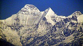
सुनन्दा देवी
स्वरूप
| सुनन्दा देवी | |
|---|---|
| नन्दा देवी पूर्व | |
 नन्दा देवी (बायाँ) तथा सुनन्दा देवी (दायाँ) | |
| सर्वोच्च विन्दु | |
| उचाइ | ७,४३४ मी (२४,३९० फिट)[१] |
| प्रमुखता | २६० मी (८५० फिट)[२][३] |
| निर्देशाङ्क | ३०°२२′००″उ॰ ७९°५९′४०″पू॰ / ३०.३६६६७°N ७९.९९४४४°Eनिर्देशाङ्कहरू: ३०°२२′००″उ॰ ७९°५९′४०″पू॰ / ३०.३६६६७°N ७९.९९४४४°E[१][४] |
| भूगोल | |
| स्थान | पिथौरागढ जिल्ला, चमौली जिल्ला, उत्तराखण्ड, भारत |
| हिमशृङ्खला | गढवाल हिमशृङ्खला |
| आरोहण | |
| पहिलो आरोहण | १९९३ मा ज्याकब बुजक तथा ज्यानुज् क्लार्नरद्वारा[५] |
| सबैभन्दा सजिलो मार्ग | दक्षिणी ढलान, हिउँको ढलान |
सुनन्दा देवी वा नन्दा देवी पूर्व भारतको उत्तराखण्डमा अवस्थित नन्दा देवी पर्वतको जुम्ल्याहा शिखर हो। यसको उचाइ ७,४३४ मी (२४,३९० फिट) रहेको छ।
सन्दर्भ सामग्रीहरू
[सम्पादन गर्नुहोस्]- ↑ १.० १.१ "High Asia I: The Karakoram, Pakistan Himalaya and India Himalaya (north of Nepal)", Peaklist.org, अन्तिम पहुँच २०१४-०५-२८।
- ↑ Corrected DEM files for the Himalaya
- ↑ Garhwal-Himalaya-Ost, 1:150,000 scale topographic map, prepared in 1992 by Ernst Huber for the Swiss Foundation for Alpine Research, based on maps of the Survey of India.
- ↑ The Himalayan Index gives the coordinates of Nanda Devi as ३०°२२′१२″उ॰ ७९°५८′१२″पू॰ / ३०.३७०००°N ७९.९७०००°E.
- ↑ Harish Kapadia, "Nanda Devi", in World Mountaineering, Audrey Salkeld, editor, Bulfinch Press, 1998, आइएसबिएन ०-८२१२-२५०२-२, pp. 254–257.


