श्रीलङ्काका जिल्लाहरू
| श्रीलङ्काका जिल्लाहरू දිස්ත්රික්ක மாவட்டம் | |
|---|---|
 | |
| श्रेणी | दोस्रो स्तरको प्रशासनिक विभाजन |
| अवस्थिति | श्रीलङ्का |
| सङ्ख्या | २५ मा |
| जनसङ्ख्या | ९२,२३८–२,३२४,३४९ |
| क्षेत्रफल | ६९९–७,१७९ वर्ग किमी |
| सरकार | जिल्ला सचिवालय |
जिल्लाहरू (सिंहली: දිස්ත්රික්ක, देवनागरी: Distrikka; तमिल: மாவட்டம்) श्रीलङ्काको दोस्रो स्तरको प्रशासनिक विभाजनहरू हुन्। श्रीलङ्कामा २५ जिल्लाहरू व्यवस्थित छन्।[१] प्रत्येक जिल्ला एक जिल्ला सचिव अन्तर्गत प्रशासित हुन्छ, जसलाई केन्द्र सरकारले नियुक्त गरेको हुन्छ। जिल्ला सचिवालयको मुख्य कार्यमा केन्द्र सरकार र प्रशासनिक सचिवालयको सञ्चार र गतिविधिलाई समन्वय गर्ने समावेश छ।[२]
इतिहास
[सम्पादन गर्नुहोस्]अनुराधापुरा राज्यको समयमा देशलाई धेरै प्रशासनिक एकाइहरूमा विभाजन गरिएको थियो। राज्यलाई तीन प्रान्तमा विभाजन गरिएको थियो; राजरता, रुहुना र मलाया रात। यिनीहरूलाई थप साना एकाइहरूमा विभाजन गरिएको थियो जसलाई राटा भनिन्छ।[३]
कालान्तरमा प्रदेश सङ्ख्या बढे पनि दोस्रो तहको प्रशासनिक विभाजन भने यथावत नै रह्यो। तर, देश अन्ततः एक भन्दा बढी राज्यमा विभाजित भएपछि र विदेशी औपनिवेशिक मिसनहरू अवतरण र देशका केही भागहरू आफ्नो नियन्त्रणमा लिएपछि यो संरचना परिवर्तन हुन थाल्यो। जाफना राज्यमा चारवटा प्रान्तसहितको यस्तै प्रशासनिक संरचना भएको देखिन्छ।[३]
सबैभन्दा नयाँ जिल्ला फेब्रुअरी १९८४ मा किलिनोच्ची जिल्ला थियो, र वर्तमान संविधानले श्रीलङ्काको क्षेत्र २५ प्रशासनिक जिल्लाहरू मिलेर बनेको छ। यी जिल्लाहरूलाई श्रीलङ्काको संसदको प्रस्तावद्वारा उपविभाजित वा एकीकरण गर्न सकिन्छ।[४]
जिल्लाहरू
[सम्पादन गर्नुहोस्]| जिल्ला | नक्सा | प्रदेश | सदरमुकाम | भूमि क्षेत्र
किमी २ |
कुल क्षेत्रफल
किमी २ |
जनसङ्ख्या
(२०१२) |
|---|---|---|---|---|---|---|
| अम्पारा | 
|
पूर्वी प्रदेश | अम्पारा | ४,२२२ (१,६३०) | ४,४१५ (१,७०५) | ६४९,४०२ |
| अनुराधापुरा | 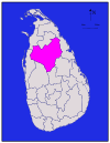
|
उत्तर मध्य प्रदेश | अनुराधापुरा | ६,६६४ (२,५७३) | ७,१७९ (२,७७२) | ८६०,५७५ |
| बदुल्ला | 
|
उवा प्रदेश | बदुल्ला | २,८२७ (१,०९२) | २,८६१ (१,१०५) | ८१५,४०५ |
| बट्टिकलोआ | 
|
पूर्वी प्रदेश | बट्टिकलोआ | २,६१० (१,०१०) | २,८५४ (१,१०२) | ५२६,५६७ |
| कोलम्बो | 
|
पश्चिमी प्रदेश | कोलम्बो | ६७६ (२६१) | ६९९ (२७०) | २,३२४,३४९ |
| गाले | 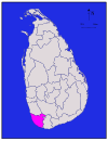
|
दक्षिणी प्रदेश | गाले | १,६१७ (६२४) | १,६५२ (६३८) | १,०६३,३३४ |
| गम्पहा | 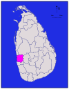
|
पश्चिमी प्रदेश | गम्पहा | १,३४१ (५१८) | १,३८७ (५३६) | २,३०४,८३३ |
| हम्बनटोटा | 
|
दक्षिणी प्रदेश | हम्बनटोटा | २,४९६ (९६४) | २,६०९ (१,००७) | ५९९,९०३ |
| जाफना | 
|
उत्तरी प्रदेश | जाफना | ९२९ (३५९) | १,०२५ (३९६) | ५८३,८८२ |
| कलुतर | 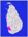
|
पश्चिमी प्रदेश | कलुतर | १,५७६ (६०८) | १,५९८ (६१७) | १,२२१,९४८ |
| क्यान्डी | 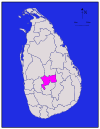
|
मध्य प्रदेश | क्यान्डी | १,९१७ (७४०) | १,९४० (७५०) | १,३७५,३८२ |
| केगल्ल | 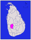
|
सबरगमुवा प्रदेश | केगल्ल | १,६८५ (६५१) | १,६९३ (६५४) | ८४०,६४८ |
| किलिनोच्चि | 
|
उत्तरी प्रदेश | किलिनोच्चि | १,२०५ (४६५) | १,२७९ (४९४) | ११३,५१० |
| कुरुनेगल | 
|
उत्तर पश्चिमी प्रदेश | कुरुनेगल | ४,६२४ (१,७८५) | ४,८१६ (१,८५९) | १,६१८,४६५ |
| मन्नार | 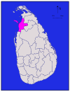
|
उत्तरी प्रदेश | मन्नार | १,८८० (७३०) | १,९९६ (७७१) | ९९,५७० |
| मातले | 
|
मध्य प्रदेश | मातले | १,९५२ (७५४) | १,९९३ (७७०) | ४८४,५३१ |
| मातर | 
|
दक्षिणी प्रदेश | मातर | १,२७० (४९०) | १,२८३ (४९५) | ८१४,०४८ |
| मुनेरगला | 
|
उवा प्रदेश | मुनेरगला | ५,५०८ (२,१२७) | ५,६३९ (२,१७७) | ४५१,०५८ |
| मुलैतिवु | 
|
उत्तरी प्रदेश | मुलैतिवु | २,४१५ (९३२) | २,६१७ (१,०१०) | ९२,२३८ |
| नुवर एलिय | 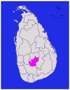
|
मध्य प्रदेश | नुवर एलिय | १,७०६ (६५९) | १,७४१ (६७२) | ७११,६४४ |
| पोलोन्नारुव | 
|
उत्तर मध्य प्रदेश | पोलोन्नारुव | ३,०७७ (१,१८८) | ३,२९३ (१,२७१) | ४०६,०८८ |
| पुत्तलम | 
|
उत्तर पश्चिमी प्रदेश | पुत्तलम | २,८८२ (१,११३) | ३,०७२ (१,१८६) | ७६२,३९६ |
| रत्नपुरा | 
|
सबरगमुवा प्रदेश | रत्नपुरा | ३,२३६ (१,२४९) | ३,२७५ (१,२६४) | १,०८८,००७ |
| त्रिन्कोमाली | 
|
पूर्वी प्रदेश | त्रिन्कोमाली | २,५२९ (९७६) | २,७२७ (१,०५३) | ३७९,५४१ |
| वावुनिया | 
|
उत्तरी प्रदेश | वावुनिया | १,८६१ (७१९) | १,९६७ (७५९) | १७२,११५ |
| कुल | ६२,७०५ (२४,२११) | ६५,६१० (२५,३३०) | २०,३५९,४३९ |
सन्दर्भ सामग्रीहरू
[सम्पादन गर्नुहोस्]- ↑ "At a Glance", Sri Lanka in Brief, Government of Sri Lanka, मूलबाट ७ जुलाई २००९-मा सङ्ग्रहित, अन्तिम पहुँच २१ जुलाई २००९।
- ↑ "Performs Report and Accounts—2008" (PDF), District and Divisional Secretariats Portal—Ministry of Public Administration and Home Affairs, मूलबाट २०११-१०-०३-मा सङ्ग्रहित, अन्तिम पहुँच २००९-०७-२९। वेब्याक मेसिन अभिलेखिकरण २०११-१०-०३ मिति
- ↑ ३.० ३.१ Yogasundaram, Nath (२००६), A Comprehensive History of Sri Lanka from Prehistory to Tsunami, Vijitha Yapa Publishers, आइएसबिएन 978-955-665-002-0।
- ↑ "Chapter 1: The People, The State and Sovereignty", The Constitution of Sri Lanka, Government of Sri Lanka, मूलबाट ३१ मे २०१४-मा सङ्ग्रहित, अन्तिम पहुँच २१ जुलाई २००९।
