
प्रयोगकर्ता:True sharad/प्रयोगस्थल
SHARAD
VALLEY OF KATHMANDU
[सम्पादन गर्नुहोस्]KATHMANDU
[सम्पादन गर्नुहोस्]Kathmandu Metropolitan City
येँ देय् काठमाडौं महानगर | |
|---|---|
 Clockwise from top: Torans seen in portals around Kathmandu, Degutaleju with Taleju in background at Kathmandu Durbar Square, Boudhanath Stupa, Bagmati river, Budhanilkantha, Singha Durbar, Swayambhunath temple at night, Pashupatinath temple | |
| आदर्श वाक्य(हरू): My legacy, my pride, my Kathmandu | |
 | |
| Country | Nepal |
| Development Region | Central |
| Zone | Bagmati Zone |
| District | Kathmandu |
| HDI | |
| HPI | |
| Literacy Rate | |
| Established | 900s BC[२] |
| सरकार | |
| • Chief Executive Officer | Kedar Bahadur Adhikari |
| क्षेत्रफल | |
| • जम्मा | ५०.६७ किमी२ (१९.५६ वर्ग माइल) |
| उन्नतांश | १,४०० मिटर (४६०० फिट) |
| जनसङ्ख्या (2011) | |
| • जम्मा | १,००३,२८५(२.५ million metropolitan area )[३] |
| census | |
| Languages | |
| • Local | Nepali, Nepal Bhasa, Sherpa, Tamang, Gurung, Magar, Sunuwar/Kiranti, Tibetan |
| • Official | Nepali, Nepal Bhasa, English |
| समय क्षेत्र | युटिसी+5:45 (Nepal Time) |
| Postal Code | 44600 (GPO), 44601, 44602, 44604, 44605, 44606, 44608, 44609, 44610, 44611, 44613, 44614, 44615, 44616, 44617, 44618, 44619, 44620, 44621 |
| क्षेत्रीय सङ्केत | 01 |
| वेबसाइट | www |
Kathmandu (नेपाली: काठमाडौं ne; नेवारी: येँ देय्) is the capital and largest municipality of Nepal. It is the only city of Nepal with the administrative status of Mahanagar (Metropolitan City), as compared to Upa-Mahanagar (Sub-Metropolitan City) or Nagar (City). Kathmandu is the core of Nepal's largest urban agglomeration located in the Kathmandu valley consisting of Lalitpur, Kirtipur, Madhyapur Thimi, Bhaktapur and a number of smaller communities. Kathmandu is also known informally as "KTM" or the "tri-city". According to the 2011 census, Kathmandu has a population of close to 1 million people. The metropolitan area is ५०.६७ वर्ग किलोमिटर (१९.५६ वर्ग माइल)[४] and has a population density of 3000per km² and 17000 per km square in city.
The city stands at an elevation of approximately १,४०० मिटर (४,६०० फिट) in the bowl-shaped Kathmandu Valley of central Nepal.[५] It is surrounded by four major mountains: Shivapuri, Phulchoki, Nagarjun, and Chandragiri. Kathmandu Valley is part of three districts (Kathmandu, Lalitpur, and Bhaktapur), has the highest population density in the country, and is home to about a twelfth of Nepal's population.
Historically, the Kathmandu Valley and adjoining areas were known as Nepal Mandala. Until the 15th century, Bhaktapur was its capital when two other capitals, Kathmandu and Lalitpur, were established.[६] During the Rana and Shah eras, British historians called the valley itself "Nepal Proper". Today, Kathmandu is not only the capital of the Federal Democratic Republic of Nepal, but also the headquarters of the Bagmati Zone and the Central Development Region of Nepal.[७]
Kathmandu is the gateway to tourism in Nepal. It is also the hub of the country's economy. It has the most advanced infrastructure of any urban area in Nepal, and its economy is focused on tourism, which accounted for 3.8% of Nepal's GDP in 1995–96. Tourism in Kathmandu declined thereafter during a period of political unrest, but since then has improved. In 2013, Kathmandu was ranked third among the top 10 travel destinations on the rise in the world by TripAdvisor, and ranked first in Asia.[८]
The city has a rich history, spanning nearly 2000 years, as inferred from inscriptions found in the valley. Religious and cultural festivities form a major part of the lives of people residing in Kathmandu. Most of Kathmandu's people follow Hinduism and many others follow Buddhism. There are people of other religious beliefs as well, giving Kathmandu a cosmopolitan culture. Nepali is the most commonly spoken language in the city. English is understood by Kathmandu's educated residents.
Toponymy
[सम्पादन गर्नुहोस्]
The city of Kathmandu was named after Kasthamandap temple, that stands in Durbar Square. In Sanskrit, Kastha (ढाँचा:Lang-sa2) means "wood" and Mandap (ढाँचा:Lang-sa2) means "covered shelter". This temple, also known as Maru Satal, was built in 1596 by King Laxmi Narsingh Malla. The two-storey structure is made entirely of wood, and uses no iron nails nor supports. According to legend, all the timber used to build this pagoda was obtained from a single tree.[९]
The colophons of ancient manuscripts, dated as late as the 20th century, refer to Kathmandu as Kasthamandap Mahanagar in Nepal Mandala. Mahanagar means "great city". The city is called "Kasthamandap" in a vow that Buddhist priests still recite to this day. Thus, Kathmandu is also known as Kasthamandap. During medieval times, the city was sometimes called Kantipur (कान्तिपुर). This name is derived from two Sanskrit words - Kanti and pur. "Kanti" is one of the names of the Goddess Lakshmi, and "pur" means place.
Among the indigenous Newar people, Kathmandu is known as Yen Desa (येँ देश), and Patan and Bhaktapur are known as Yala Desa (यल देश) and Khwopa Desa (ख्वप देश).[१०] "Yen" is the shorter form of Yambu (यम्बु), which originally referred to the northern half of Kathmandu.[clarification needed][११]
History
[सम्पादन गर्नुहोस्]
Archaeological excavations in parts of Kathmandu have found evidence of ancient civilizations. The oldest of these findings is a statue, found in Maligaon, that was dated at 185 AD.[१२] The excavation of Dhando Chaitya uncovered a brick with an inscription in Brahmi script. Archaeologists believe it is two thousand years old.[१२] Stone inscriptions are an ubiquitous element at heritage sites and are key sources for the history of Nepal
The earliest Western reference to Kathmandu appears in an account of Jesuit Fathers Johann Grueber and Albert d'Orville. In 1661, they passed through Nepal on their way from Tibet to India, and reported that they reached "Cadmendu, the capital of the Kingdom of Necbal".[१३]
Ancient history
[सम्पादन गर्नुहोस्]The ancient history of Kathmandu is described in its traditional myths and legends. According to Swayambhu Purana, the present day Kathmandu was once a lake called Nagdaha. The lake was drained by Manjusri, who established a city called Manjupattan and made Dharmakar the ruler of the land.[१४][१५][१६]
Kotirudra Samhita of Shiva Purana, Chapter 11, shloka 18 refers to the place as Nayapala city famous for its Pashupati Shivalinga. The name Nepal probably originates from this city Nayapala.
Very few historical records exist of the period before the medieval Licchavis rulers. According to Gopalraj Vansawali, a genealogy of Nepali monarchs, the rulers of Kathmandu Valley before the Licchavis were Gopalas, Mahispalas, Aabhirs, Kirants, and Somavanshi.[१६][१७] The Kirata dynasty was established by Yalamber. During the Kirata era, a settlement called Yambu existed in the northern half of old Kathmandu. In some of the Sino-Tibetan languages, Kathmandu is still called Yambu. Another smaller settlement called Yengal was present in the southern half of old Kathmandu, near Manjupattan. During the reign of the seventh Kirata ruler, Jitedasti, Buddhist monks entered Kathmandu valley and established a forest monastery at Sankhu.
Medieval history
[सम्पादन गर्नुहोस्]
Licchavi era
[सम्पादन गर्नुहोस्]The Licchavis from the Indo-Gangetic plain migrated north and defeated the Kiratas, establishing the Licchavi dynasty. During this era, following the genocide of Shakyas in Lumbini by Virudhaka, the survivors migrated north and entered the forest monastery in Sankhu masquerading as Koliyas. From Sankhu, they migrated to Yambu and Yengal (Lanjagwal and Manjupattan) and established the first permanent Buddhist monasteries of Kathmandu. This created the basis of Newar Buddhism, which is the only surviving Sanskrit-based Buddhist tradition in the world.[१८] With their migration, Yambu was called Koligram and Yengal was called Dakshin Koligram[१९] during most of the Licchavi era.[२०]
Eventually, the Licchavi ruler Gunakamadeva merged Koligram and Dakshin Koligram, founding the city of Kathmandu.[२०] The city was designed in the shape of Chandrahrasa, the sword of Manjushri. The city was surrounded by eight barracks guarded by Ajimas. One of these barracks is still in use at Bhadrakali (in front of Singha Durbar). The city served as an important transit point in the trade between India and Tibet, leading to tremendous growth in architecture. Descriptions of buildings such as Managriha, Kailaskut Bhawan, and Bhadradiwas Bhawan have been found in the surviving journals of travelers and monks who lived during this era. For example, the famous 7th-century Chinese traveller Xuanzang described Kailaskut Bhawan, the palace of the Licchavi king Amshuverma.[२१] The trade route also led to cultural exchange as well. The artistry of the Newar people—the indigenous inhabitants of the Kathmandu Valley—became highly sought after during this era, both within the Valley and throughout the greater Himalayas. Newar artists travelled extensively throughout Asia, creating religious art for their neighbors. For example, Araniko led a group of his compatriot artists through Tibet and China. Bhrikuti, the princess of Nepal who married Tibetan monarch Songtsän Gampo, was instrumental in introducing Buddhism to Tibet.
Malla era
[सम्पादन गर्नुहोस्]
The Licchavi era was followed by the Malla era. Rulers from Tirhut, upon being attacked by Muslims, fled north to the Kathmandu valley. They intermarried with Nepali royalty, and this led to the Malla era. The early years of the Malla era were turbulent, with raids and attacks from Khas and Turk Muslims. There was also a devastating earthquake which claimed the lives of a third of Kathmandu's population, including the king Abhaya Malla. These disasters led to the destruction of most of the architecture of the Licchavi era (such as Mangriha and Kailashkut Bhawan), and the loss of literature collected in various monasteries within the city. Despite the initial hardships, Kathmandu rose to prominence again and, during most of the Malla era, dominated the trade between India and Tibet. Nepali currency became the standard currency in trans-Himalayan trade.
During the later part of the Malla era, Kathmandu Valley comprised four fortified cities: Kantipur, Lalitpur, Bhaktapur, and Kirtipur. These served as the capitals of the Malla confederation of Nepal. These states competed with each other in the arts, architecture, aesthetics, and trade, resulting in tremendous development. The kings of this period directly influenced or involved themselves in the construction of public buildings, squares, and temples, as well as the development of water spouts, the institutionalization of trusts (called guthis), the codification of laws, the writing of dramas, and the performance of plays in city squares. Evidence of an influx of ideas from India, Tibet, China, Persia, and Europe among other places can be found in a stone inscription from the time of king Pratap Malla. Books have been found from this era that describe their tantric tradition (e.g. Tantrakhyan), medicine (e.g. Haramekhala), religion (e.g. Mooldevshashidev), law, morals, and history. Amarkosh, a Sanskrit-Nepal Bhasa dictionary from 1381 AD, was also found. Architecturally notable buildings from this era include Kathmandu Durbar Square, Patan Durbar Square, Bhaktapur Durbar Square, the former durbar of Kirtipur, Nyatapola, Kumbheshwar, the Krishna temple, and others.
Modern era
[सम्पादन गर्नुहोस्]
Early Shah rule
[सम्पादन गर्नुहोस्]The Gorkha Kingdom ended the Malla confederation after the Battle of Kathmandu in 1768. This marked the beginning of the modern era in Kathmandu. The Battle of Kirtipur was the start of the Gorkha conquest of the Kathmandu Valley. Kathmandu was adopted as the capital of the Gorkha empire, and the empire itself was dubbed Nepal. During the early part of this era, Kathmandu maintained its distinctive culture. Buildings with characteristic Nepali architecture, such as the nine-story tower of Basantapur, were built during this era. However, trade declined because of continual war with neighboring nations. Bhimsen Thapa supported France against Great Britain; this led to the development of modern military structures, such as modern barracks in Kathmandu. Dharahara, the nine storied tower, was built during this era.
Rana rule
[सम्पादन गर्नुहोस्]Rana rule over Nepal started with the Kot Massacre, which occurred near Hanuman Dhoka Durbar. During this massacre, most of Nepal's high-ranking officials were massacred by Jang Bahadur Rana and his supporters. Another massacre, the Bhandarkhal Massacre, was also conducted by Kunwar and his supporters in Kathmandu. During the Rana regime, Kathmandu's alliance shifted from anti-British to pro-British; this led to the construction of the first buildings in the style of Western European architecture. The most well-known of these buildings include Singha Durbar, Garden of Dreams, Shital Niwas, and the old Narayanhiti palace. The first modern commercial road in the Kathmandu Valley, the New Road, was also built during this era. Trichandra College (the first college of Nepal), Durbar School (the first modern school of Nepal), and Bir Hospital (the first hospital of Nepal) were built in Kathmandu during this era. Rana rule was marked by tyranny, debauchery, economic exploitation and religious persecution.[२२][२३]
Geography
[सम्पादन गर्नुहोस्]

Kathmandu is located in the northwestern part of Kathmandu Valley to the north of the Bagmati River and covers an area of ५०.६७ वर्ग किलोमिटर (१९.५६ वर्ग माइल). The average elevation is १,४०० मिटर (४,६०० फिट) above sea level.[५] The city is directly bounded by several other municipalities of the Kathmandu valley: south of the Bagmati by Lalitpur Sub-Metropolitan City (Patan) with which it today forms one urban area surrounded by a ring road, to the southwest by Kirtipur Municipality and to the east by Madyapur Thimi Municipality. To the north the urban area extends into several Village Development Committees. However, the urban agglomeration extends well beyond the neighbouring municipalities, e. g. to Bhaktapur and just about covers the entire Kathmandu valley.
Kathmandu is dissected by eight rivers, the main river of the valley, the Bagmati and its tributaries, of which the Bishnumati, Dhobi Khola, Manohara Khola, Hanumant Khola, and Tukucha Khola are predominant. The mountains from where these rivers originate are in the elevation range of १,५००–३,००० मिटर (४,९००–९,८०० फिट), and have passes which provide access to and from Kathmandu and its valley.[४][२४][२५] An ancient canal once flowed from Nagarjuna hill through Balaju to Kathmandu; this canal is now extinct.
Kathmandu and its valley are in the Deciduous Monsoon Forest Zone (altitude range of १,२००–२,१०० मिटर (३,९००–६,९०० फिट)), one of five vegetation zones defined for Nepal. The dominant tree species in this zone are oak, elm, beech, maple and others, with coniferous trees at higher altitude.[२६]

Kathmandu agglomeration
[सम्पादन गर्नुहोस्]The agglomeration of Kathmandu has not yet been officially defined. The urban area of the Kathmandu valley is split among three different districts which extend very little beyond the valley fringe. They have the three highest population densities in the country. The following data table describes the area.
| Administrative district | Area (km²) | Population (2001 Census) | Population (2011 Census) | Population density (/km²) |
|---|---|---|---|---|
| Kathmandu | 395 | 1,081,845 | 1,740,977 | 4408 |
| Lalitpur | 385 | 337,785 | 466,784 | 1212 |
| Bhaktapur | 119 | 225,461 | 303,027 | 2546 |
| Kathmandu agglomeration | 899 | 1,645,091 | 2,510,788 | 2793 |
Climate
[सम्पादन गर्नुहोस्]| Kathmandu | ||||||||||||||||||||||||||||||||||||||||||||||||||||||||||||
|---|---|---|---|---|---|---|---|---|---|---|---|---|---|---|---|---|---|---|---|---|---|---|---|---|---|---|---|---|---|---|---|---|---|---|---|---|---|---|---|---|---|---|---|---|---|---|---|---|---|---|---|---|---|---|---|---|---|---|---|---|
| जलवायु तालिका | ||||||||||||||||||||||||||||||||||||||||||||||||||||||||||||
| ||||||||||||||||||||||||||||||||||||||||||||||||||||||||||||
| ||||||||||||||||||||||||||||||||||||||||||||||||||||||||||||
Five major climatic regions are found in Nepal. Of these, Kathmandu Valley is in the Warm Temperate Zone (elevation ranging from १,२००–२,३०० मिटर (३,९००–७,५०० फिट)), where the climate is fairly temperate, atypical for the region. This zone is followed by the Cool Temperate Zone with elevation varying between २,१००–३,३०० मिटर (६,९००–१०,८०० फिट). Under Köppen's climate classification, portions of the city with lower elevations have a humid subtropical climate (Cwa), while portions of the city with higher elevations generally have a subtropical highland climate. In the Kathmandu Valley, which is representative of its valley's climate, the average summer temperature varies from २८–३० °से (८२–८६ °फे). The average winter temperature is १०.१ °से (५०.२ °फे).
The city generally has a climate with warm days followed by cool nights and mornings. Unpredictable weather is expected given temperatures can drop to ३ °से (३७ °फे) during the winter. During a 2013 cold front, the winter temperatures of Kathmandu dropped to −४ °से (२५ °फे), and the coldest temperature was recorded on January 10, 2013 at −९.२ °से (१५.४ °फे). Rainfall is mostly monsoon-based (about 65% of the total concentrated during the monsoon months of June to August), and decreases substantially (१०० देखि २०० सेमी (३९ देखि ७९ इन्च)) from eastern Nepal to western Nepal. Rainfall has been recorded at about १,४०० मिलिमिटर (५५.१ इन्च) for the Kathmandu valley, and averages १,४०७ मिलिमिटर (५५.४ इन्च) for the city of Kathmandu. On average humidity is 75%.[४][२७][२८] The chart below is based on data from the Nepal Bureau of Standards & Meteorology, "Weather Meteorology" for 2005. The chart provides minimum and maximum temperatures during each month. The annual amount of precipitation was १,१२४ मिलिमिटर (४४.३ इन्च) for 2005, as per monthly data included in the table above.[२८] The decade of 2000-2010 saw highly variable and unprecedented precipitation anomalies in Kathmandu. This was mostly due to the annual variation of the southwest monsoon.[स्रोत नखुलेको] For example, 2003 was the wettest year ever in Kathmandu, totalling over २,९०० मिमी (११४ इन्च) of precipitation due to an exceptionally strong monsoon season. In contrast, 2001 recorded only ३५६ मिमी (१४ इन्च) of precipitation due to an extraordinarily weak monsoon season.
| Kathmandu (1981-2010)को मौसम जानकारी | |||||||||||||
|---|---|---|---|---|---|---|---|---|---|---|---|---|---|
| महिना | जनवरी | फेब्रुअरी | मार्च | अप्रिल | मे | जुन | जुलाई | अगस्ट | सेप्टेम्बर | अक्टोबर | नोभेम्बर | डिसेम्बर | वर्ष |
| उच्चतम रेकर्ड °से (°फे) | २४.४ (७५.९) |
२८.३ (८२.९) |
३३.३ (९१.९) |
३५.० (९५.०) |
३६.१ (९७.०) |
३७.२ (९९.०) |
३२.८ (९१.०) |
३३.३ (९१.९) |
३३.३ (९१.९) |
३३.३ (९१.९) |
२९.४ (८४.९) |
२८.३ (८२.९) |
३७.२ (९९.०) |
| उच्चतम औसत °से (°फे) | १९.१ (६६.४) |
२१.४ (७०.५) |
२५.३ (७७.५) |
२८.२ (८२.८) |
२८.७ (८३.७) |
२९.१ (८४.४) |
२८.४ (८३.१) |
२८.७ (८३.७) |
२८.१ (८२.६) |
२६.८ (८०.२) |
२३.६ (७४.५) |
२०.२ (६८.४) |
२५.६ (७८.१) |
| न्यूनतम औसत °से (°फे) | २.४ (३६.३) |
४.५ (४०.१) |
८.२ (४६.८) |
११.७ (५३.१) |
१५.७ (६०.३) |
१९.१ (६६.४) |
२०.२ (६८.४) |
२०.० (६८.०) |
१८.५ (६५.३) |
१३.४ (५६.१) |
७.८ (४६.०) |
३.७ (३८.७) |
१२.१ (५३.८) |
| न्यूनतम रेकर्ड °से (°फे) | −२.८ (२७.०) |
−१.१ (३०.०) |
१.७ (३५.१) |
४.४ (३९.९) |
९.४ (४८.९) |
१३.९ (५७.०) |
१६.१ (६१.०) |
१६.१ (६१.०) |
१३.३ (५५.९) |
५.६ (४२.१) |
०.६ (३३.१) |
−१.७ (२८.९) |
−२.८ (२७.०) |
| औसत वर्षा मिमी (इन्च) | १४.४ (०.५७) |
१८.७ (०.७४) |
३४.२ (१.३५) |
६१.० (२.४०) |
१२३.६ (४.८७) |
२३६.३ (९.३०) |
३६३.४ (१४.३१) |
३३०.८ (१३.०२) |
१९९.८ (७.८७) |
५१.२ (२.०२) |
८.३ (०.३३) |
१३.२ (०.५२) |
१,४५४.९ (५७.२८) |
| दैनिक औसत वर्षा | २ | ३ | ४ | ६ | १२ | १७ | २३ | २२ | १५ | ४ | १ | १ | ११० |
| औसत सापेक्ष आर्द्रता (%) | ७९ | ७१ | ६१ | ५३ | ५७ | ७३ | ८१ | ८३ | ८२ | ७९ | ८५ | ८० | ७४ |
| मासिक सौर्यप्रकाश घण्टा औसत | २२३ | २५४ | २६० | २३१ | २२९ | १८६ | १३६ | १५९ | १३२ | २५२ | २४४ | २५० | २,५५६ |
| स्रोत १: Department of Hydrology and Meteorology ,[२९] World Meteorological Organization (precipitation days)[३०] | |||||||||||||
| स्रोत २: Danish Meteorological Institute (sun and relative humidity),[३१] Sistema de Clasificación Bioclimática Mundial (extremes) [३२] | |||||||||||||
Economy
[सम्पादन गर्नुहोस्]
The location and terrain of Kathmandu have played a significant role in the development of a stable economy which spans millennia. The city is located in an ancient lake basin, with fertile soil and flat terrain. This geography helped form a society based on agriculture. This, combined with its location between India and China, helped establish Kathmandu as an important trading center over the centuries. Kathmandu's trade is an ancient profession that flourished along an offshoot of the Silk Road which linked India and Tibet. From centuries past, Lhasa Newar merchants of Kathmandu have conducted trade across the Himalaya and contributed to spreading art styles and Buddhism across Central Asia.[३३] Other traditional occupations are farming, metal casting, woodcarving, painting, weaving, and pottery.[३४]
Kathmandu is the most important industrial and commercial center in Nepal. The Nepal Stock Exchange, the head office of the national bank, the chamber of commerce, as well as head-offices of national and international banks, tele-communication companies, the electricity authority, and various other national and international organizations are located in Kathmandu. The major economic hubs are the New Road, Durbar Marg, Ason and Putalisadak.[३४]
The economic output of the metropolitan area alone is worth more than one third of national GDP around $6.5billion in terms of nominal GDP NR.s 550 billion approximately per year $2200 per capital income approx three times national average.[३५] Kathmandu exports handicrafts, artworks, garments, carpets, pashmina, paper; trade accounts for 21% of its finances.[कुन?][३४][३५] Manufacturing is also important and accounts for 19% of the revenue that Kathmandu generates. Garments and woolen carpets are the most notable manufactured products.[३५] Other economic sectors in Kathmandu include agriculture (9%), education (6%), transport (6%), and hotels and restaurants (5%).[३५] Kathmandu is famous for lokta paper and pashmina shawls.
Tourism
[सम्पादन गर्नुहोस्]

Tourism is considered another important industry in Nepal. This industry started around 1950, as the country's political makeup changed and ended the country's isolation from the rest of the world. In 1956, air transportation was established and the Tribhuvan Highway, between Kathmandu and Raxaul (at India's border), was started. Separate organizations were created in Kathmandu to promote this activity; some of these include the Tourism Development Board, the Department of Tourism and the Civil Aviation Department. Furthermore, Nepal became a member of several international tourist associations. Establishing diplomatic relations with other nations further accentuated this activity. The hotel industry, travel agencies, training of tourist guides, and targeted publicity campaigns are the chief reasons for the remarkable growth of this industry in Nepal, and in Kathmandu in particular.[३६]
Since then, tourism in Nepal has thrived; it is sometimes called the "third religion" of Nepal. It is the country's most important industry.[स्रोत नखुलेको] Tourism is a major source of income for most of the people in the city, with several hundred thousand visitors annually. Hindu and Buddhist pilgrims from all over the world visit Kathmandu's religious sites such as Pashupatinath, Swayambhunath, Boudhanath and Budhanilkantha. From a mere 6,179 tourists in 1961–62, the number jumped to 491,504 in 1999-2000. With the end of Maoist insuregency period in 2009 there was a significant rise of 509,956 tourist arrivals. Since then, tourism has improved as the country turned into a Democratic Republic. In economic terms, the foreign exchange registered 3.8% of the GDP in 1995–96 but then started decliningढाँचा:Why. The high level of tourism is attributed to the natural grandeur of the Himalayas and the rich cultural heritage of the country.[३६]
The neighborhood of Thamel is Kathmandu's primary "traveler's ghetto", packed with guest houses, restaurants, shops, and bookstores, catering to tourists. Another neighborhood of growing popularity is Jhamel, a name for Jhamsikhel coined to rhyme with Thamel.[३७] Jhochhen Tol, also known as Freak Street, is Kathmandu's original traveler's haunt, made popular by the hippies of the 1960s and 1970s; it remains a popular alternative to Thamel. Asan is a bazaar and ceremonial square on the old trade route to Tibet, and provides a fine example of a traditional neighborhood.
With the opening of the tourist industry after the change in the political scenario of Nepal in 1950, the hotel industry drastically improved.[३८] Now Kathmandu boasts several five-star hotels like Hyatt Regency, Hotel Yak & Yeti, The Everest Hotel, Hotel Radisson, Hotel De L'Annapurna, The Malla Hotel, Shangri-La Hotel and The Shanker Hotel. There are several four-star hotels such as Hotel Vaishali, Hotel Narayani, The Blue Star and Grand Hotel. The Garden Hotel, Hotel Ambassador, and Aloha Inn are among the three-star hotels in Kathmandu. Hotels like Hyatt Regency, De L'Annapurna and Hotel Yak & Yeti are among the five-star hotels providing casinos as well.[३९]
Government and public services
[सम्पादन गर्नुहोस्]Civic administration
[सम्पादन गर्नुहोस्]


Kathmandu Municipal Corporation, abbreviated KMC, is the chief nodal agency for the administration of Kathmandu. The Municipality of Kathmandu was upgraded to incorporated in 1994.
Metropolitan Kathmandu is divided into five sectors: the Central Sector, the East Sector, the North Sector, the City Core and the West Sector. For civic administration, the city is further divided into 35 administrative wards. The Council administers the Metropolitan area of Kathmandu city through its 177 elected representatives and 20 nominated members. It holds biannual meetings to review, process and approve the annual budget and make major policy decisions.[४][४०] The ward's profile documents for the 35 wards prepared by the Kathmandu Metropolitan Council is detailed and provides information for each ward on population, the structure and condition of houses, the type of roads, educational, health and financial institutions, entertainment facilities, parking space, security provisions, etc. It also includes lists of development projects completed, on-going and planned, along with informative data about the cultural heritage, festivals, historical sites and the local inhabitants. Ward 16 is the largest, with an area of 437.4 ha; ward 26 is the smallest, with an area of 4 ha.[४१]
Kathmandu is headquarters of the surrounding Kathmandu District. The city of Kathmandu forms this district with Kirtipur Municipality and some 57 Village Development Committees.
According to the 2001 census, there are 235,387 households in the metropolitan city.
Development Authority
[सम्पादन गर्नुहोस्]Kathmandu Valley Development Authority, abbreviated as KVDA, is a body of the Government of Nepal that is responsible for the infrastructure development of the city Kathmandu. It undertakes developmental activities in various sectors such as architecture, town planning, and engineering.
Law and order
[सम्पादन गर्नुहोस्]The Metropolitan Police is the main law enforcement agency in the city. It is headed by a commissioner of police. The Metropolitan Police is a division of the Nepal Police, and the administrative control lies with the National Home Ministry.
Fire service
[सम्पादन गर्नुहोस्]The fire service, known as the Barun Yantra Karyalaya, opened its first station in Kathmandu in 1937 with a single vehicle.[४२] An iron tower was erected to monitor the city and watch for fire. As a precautionary measure, firemen were sent to the areas which were designated as accident-prone areas.[४२] In 1944, the fire service was extended to the neighboring cities of Lalitpur and Bhaktapur. In 1966, a fire service was established in Kathmandu airport.[४२] In 1975, a German government donation added seven fire engines to Kathmandu's fire service.[४२] The fire service in the city is also overlooked by an international non-governmental organization, the Firefighters Volunteer Association of Nepal (FAN), which was established in 2000 with the purpose of raising public awareness about fire and improving safety.[४२]
Electricity and Water Supply (बिधुत र खानेपानी )
[सम्पादन गर्नुहोस्]Electricity in Kathmandu is regulated and distributed by the NEA Nepal Electricity Authority. while water supply and sanitation facilities are provided by the Kathmandu Upatyaka Khanepani Limited (KUKL). There is a severe shortage of water for house hold purpose such as drinking, bathing, cooking and washing. People have been using mineral water bottle and mineral water tanks for all the purposes related to water.
Demographics
[सम्पादन गर्नुहोस्]Kathmandu's urban cosmopolitan character has made it the most populous city in Nepal, recording a population of 671,846 residents living in 235,387 households in the metropolitan area, according to the 2001 census.[४३] According to the National Population Census of 2011, the total population of Kathmandu city was 975,543 with an annual growth rate of 6.12% with respect to the population figure of 2001. 70% of the total population residing in Kathmandu are aged between 15 and 59.
Over the years the city has been home to people of various ethnicities, resulting in a range of different traditions and cultural practices. In one decade, the population increased from 427,045 in 1991 to 671,805 in 2001. The population was projected to reach 915,071 in 2011 and 1,319,597 by 2021. To keep up this population growth, the KMC-controlled area of ५,०७६.६ हेक्टर (१२,५४५ एकड) has expanded to ८,२१४ हेक्टर (२०,३०० एकड) in 2001. With this new area, the population density which was 85 in 1991 is still 85 in 2001; it is likely to jump to 111 in 2011 and 161 in 2021.[४४]
Ethnic groups
[सम्पादन गर्नुहोस्]The largest ethnic groups are Newar (29.6%), Matwali (25.1% Sunuwar, Gurung, Magars, Tamang etc.), Khas Brahmins (20.51%)and Chettris (18.5%) .[४५] Tamangs originating from surrounding hill districts can be seen in Kathmandu. More recently, other hill ethnic groups and Caste groups from Terai have become present as well in vast majority. The major languages are Nepali, Nepal Bhasa and English is understood by majority of People (about 90%). The major religions are Hinduism and Buddhism.
The linguistic profile of Kathmandu underwent drastic changes during the Shah dynasty's rule because of its strong bias towards the Brahminic culture. Sanskrit language therefore was preferred and people were encouraged to learn it even by attending Sanskrit learning centers in Terai. Sanskrit schools were specially set up in Kathmandu and in the Terai region to inculcate traditional Hindu culture and practices originated from Nepal.[४६]
Architecture and cityscape
[सम्पादन गर्नुहोस्]| काठमाडौँ उपत्यकाका विश्व सम्पदा क्षेत्रहरू (सात धरोहर र भवनहरू)
• सन् २००७ मा काठमाडौँ दरबार क्षेत्र • • पशुपतिनाथ • चाँगुनारायण • • स्वयम्भूनाथ • बौद्धनाथ • • पाटन दरबार क्षेत्र • • भक्तपुर दरबार क्षेत्र • |
|---|


.jpg)


The ancient trade route between India and Tibet that passed through Kathmandu enabled a fusion of artistic and architectural traditions from other cultures to be amalgamated with local art and architecture.[४७] The monuments of Kathmandu City have been influenced over the centuries by Hindu and Buddhist religious practices. The architectural treasure of the Kathmandu valley has been categorized under the well-known seven groups of heritage monuments and buildings. In 2006 UNESCO declared these seven groups of monuments as a World Heritage Site (WHS). The seven monuments zones cover an area of १८८.९५ हेक्टर (४६६.९ एकड), with the buffer zone extending to २३९.३४ हेक्टर (५९१.४ एकड). The Seven Monument Zones (Mzs) inscribed originally in 1979 and with a minor modification in 2006 are Durbar squares of Hanuman Dhoka, Patan and Bhaktapur, Hindu temples of Pashupatinath and Changunarayan, the Buddhist stupas of Swayambhu and Boudhanath.[४८][४९]
Durbar squares
[सम्पादन गर्नुहोस्]- The literal meaning of Durbar Square is a "place of palaces". There are three preserved Durbar Squares in Kathmandu valley and one unpreserved in Kirtipur. The Durbar Square of Kathmandu is located in the old city and has heritage buildings representing four kingdoms (Kantipur, Lalitpur, Bhaktapur, Kirtipur); the earliest is the Licchavi dynasty. The complex has 50 temples and is distributed in two quadrangles of the Durbar Square. The outer quadrangle has the Kasthamandap, Kumari Ghar, and Shiva-Parvati Temple; the inner quadrangle has the Hanuman Dhoka palace.
- Hanuman Dhoka is a complex of structures with the Royal Palace of the Malla kings and of the Shah dynasty. It is spread over five acres. The eastern wing, with ten courtyards, is the oldest part, dating to the mid-16th century. It was expanded by King Pratap Malla in the 17th century with many temples. The royal family lived in this palace until 1886 when they moved to Narayanhiti Palace. The stone inscription outside is in fifteen languages.[५०]
- Kumari Ghar is a palace in the center of the Kathmandu city, next to the Durbar square where a Royal Kumari selected from several Kumaris resides. Kumari, or Kumari Devi, is the tradition of worshipping young pre-pubescent girls as manifestations of the divine female energy or devi in South Asian countries. In Nepal the selection process is very rigorous. Kumari is believed to be the bodily incarnation of the goddess Taleju (the Nepali name for Durga) until she menstruates, after which it is believed that the goddess vacates her body. Serious illness or a major loss of blood from an injury are also causes for her to revert to common status. The current Royal Kumari, Matina Shakya, age four, was installed in October 2008 by the Maoist government that replaced the monarchy.[५१]
- Kasthamandap is a three-storeyed temple enshrining an image of Gorakhnath. It was built in the 16th century in pagoda style. The name of Kathmandu is a derivative of the word Kasthamandap. It was built under the reign of King Laxmi Narsingha Malla. Kasthamandap stands at the intersection of two ancient trade routes linking India and Tibet at Maru square. It was originally built as a rest house for travelers.
Pashupatinath temple
[सम्पादन गर्नुहोस्]
The Pashupatinath Temple is a famous 5th century Hindu temple dedicated to Lord Shiva (Pashupati). Located on the banks of the Bagmati River in the eastern part of Kathmandu, Pashupatinath Temple is the oldest Hindu temple in Kathmandu.[५२] It served as the seat of national deity, Lord Pashupatinath, until Nepal was secularized. However, a significant part of the temple was destroyed by Mughal invaders in the 14th century and little or nothing remains of the original 5th-century temple exterior. The temple as it stands today was built in the 19th century, although the image of the bull and the black four-headed image of Pashupati are at least 300 years old.[५३] The temple is a UNESCO World Heritage Site.[५३][५४] Shivaratri, or the night of Lord Shiva, is the most important festival that takes place here, attracting thousands of devotees and sadhus.[स्रोत नखुलेको]
Believers in Pashupatinath (mainly Hindus) are allowed to enter the temple premises, but non-Hindu visitors are allowed to view the temple only from the across the Bagmati River.[५३] The priests who perform the services at this temple have been Brahmins from Karnataka, South India since the time of Malla king Yaksha Malla.[५५] This tradition is believed to have been started at the request of Adi Shankaracharya who sought to unify the states of Bharatam (Unified India) by encouraging cultural exchange. This procedure is followed in other temples around India, which were sanctified by Adi Shankaracharya.
The temple is built in the pagoda style of architecture, with cubic constructions, carved wooden rafters (tundal) on which they rest, and two-level roofs made of copper and gold.
Boudhanath
[सम्पादन गर्नुहोस्]

The Boudhanath, (also written Bouddhanath, Bodhnath, Baudhanath or the Khāsa Chaitya), is one of the holiest Buddhist sites in Nepal, along with Swayambhu. It is a very popular tourist site. Boudhanath is known as Khāsti by Newars and as Bauddha or Bodhnāth by speakers of Nepali.[५६] Located about ११ किमी (७ माइल) from the center and northeastern outskirts of Kathmandu, the stupa's massive mandala makes it one of the largest spherical stupas in Nepal.[५७] Boudhanath became a UNESCO World Heritage Site in 1979.
The base of the stupa has 108 small depictions of the Dhyani Buddha Amitabha. It is surrounded with a brick wall with 147 niches, each with four or five prayer wheels engraved with the mantra, om mani padme hum.[५८] At the northern entrance where visitors must pass is a shrine dedicated to Ajima, the goddess of smallpox.[५८] Every year the stupa attracts many Tibetan Buddhist pilgrims who perform full body prostrations in the inner lower enclosure, walk around the stupa with prayer wheels, chant, and pray.[५८] Thousands of prayer flags are hoisted up from the top of the stupa downwards and dot the perimeter of the complex. The influx of many Tibetan refugees from China has seen the construction of over 50 Tibetan gompas (monasteries) around Boudhanath.
Swayambhu
[सम्पादन गर्नुहोस्]Swayambhu is a Buddhist stupa atop a hillock at the northwestern part of the city. This is among the oldest religious sites in Nepal. Although the site is considered Buddhist, it is revered by both Buddhists and Hindus. The stupa consists of a dome at the base; above the dome, there is a cubic structure with the eyes of Buddha looking in all four directions.[clarification needed] There are pentagonal Toran above each of the four sides, with statues engraved on them. Behind and above the torana there are thirteen tiers. Above all the tiers, there is a small space above which lies a gajur.
Culture
[सम्पादन गर्नुहोस्]Arts
[सम्पादन गर्नुहोस्]
Kathmandu valley is described as "an enormous treasure house of art and sculptures", which are made of wood, stone, metal, and terracotta, and found in profusion in temples, shrines, stupas, gompas, chaityasm and palaces. The art objects are also seen in street corners, lanes, private courtyards, and in open ground. Most art is in the form of icons of gods and goddesses. Kathmandu valley has had this art treasure very long, but received worldwide recognition only after the country opened its doors to the outside world in 1950.[४६]
The religious art of Nepal and Kathmandu in particular consists of an iconic symbolism of the Mother Goddesses such as: Bhavani, Durga, Gaja-Lakshmi, Hariti-Sitala, Mahsishamardini, Saptamatrika (seven mother goddesses), and Sri-Lakshmi(wealth-goddess). From the 3rd century BC, apart from the Hindu gods and goddesses, Buddhist monuments from the Ashokan period (it is said that Ashoka visited Nepal in 250 BC) have embellished Nepal in general and the valley in particular. These art and architectural edifices encompass three major periods of evolution: the Licchavi or classical period (500 to 900 AD), the post-classical period (1000 to 1400 AD), with strong influence of the Palla art form; the Malla period (1400 onwards) that exhibited explicitly tantric influences coupled with the art of Tibetan Demonology.[५९]
A broad typology has been ascribed to the decorative designs and carvings created by the people of Nepal. These artists have maintained a blend of Hinduism and Buddhism. The typology, based on the type of material used are: Stone Art, Metal Art, Wood Art, Terracotta Art, and Painting.[६०]
Museums
[सम्पादन गर्नुहोस्]

Kathmandu is home to a number of museums and art galleries, including the National Museum of Nepal and the Natural History Museum of Nepal. Nepal's art and architecture is an amalgamation of two ancient religions, Hinduism and Buddhhism. These are amply reflected in the many temples, shrines, stupas, monasteries, and palaces in the seven well-defined Monument Zones of the Kathmandu valley recognized as a UNESCO World Heritage Site. This amalgamation is also reflected in the planning and exhibitions in museums and art galleries throughout Kathmandu and its sister cities of Patan and Bhaktapur. The museums display unique artifacts and paintings from the 5th century CE to the present day, including archeological exportation.[६१]
Kathmandu museums and art galleries include:[६१]
- The National Museum
- The Natural History Museum
- Hanumandhoka Palace Complex
- The Kaiser Library
- The National Art Gallery
- The NEF-ART (Nepal Fine Art) Gallery
- The Nepal Art Council Gallery
- Narayanhity Palace Museum
- The Taragaon Museum

The National Museum is located in the western part of Kathmandu, near the Swayambhunath stupa in an historical building. This building was constructed in the early 19th century by General Bhimsen Thapa. It is the most important museum in the country, housing an extensive collection of weapons, art and antiquities of historic and cultural importance.[६२] The museum was established in 1928 as a collection house of war trophies and weapons, and the initial name of this museum was Chhauni Silkhana, meaning "the stone house of arms and ammunition". Given its focus, the museum contains an extensive quantity of weapons, including locally made firearms used in wars, leather cannons from the 18th–19th century, and medieval and modern works in wood, bronze, stone and paintings.[६२]
The Natural History Museum is located in the southern foothills of Swayambhunath hill and has a sizeable collection of different species of animals, butterflies, and plants. The museum is noted for its display of species, from prehistoric shells to stuffed animals.[६२]
The Tribhuvan Museum contains artifacts related to the King Tribhuvan (1906–1955). It has a variety of pieces including his personal belongings, letters and papers, memorabilia related to events he was involved in and a rare collection of photos and paintings of Royal family members.[६२] The Mahendra Museum is dedicated to king Mahendra of Nepal (1920–1972). Like the Tribhuvan Museum, it includes his personal belongings such as decorations, stamps, coins and personal notes and manuscripts, but it also has structural reconstructions of his cabinet room and office chamber.[६२] The Hanumandhoka Palace, a lavish medieval palace complex in the Durbar, contains three separate museums of historic importance. These museums include the Birendra museum, which contains items related to the second-last monarch, Birendra of Nepal.[६२]
The enclosed compound of the Narayanhity Palace Museum is in the north-central part of Kathmandu. "Narayanhity" comes from Narayana, a form of the Hindu god Lord Vishnu, and Hiti, meaning "water spout" (Vishnu's temple is located opposite the palace, and the water spout is located east of the main entrance to the precinct). Narayanhity was a new palace, in front of the old palace built in 1915, and was built in 1970 in the form of a contemporary Pagoda. It was built on the occasion of the marriage of King Birenda Bir Bikram Shah, then heir apparent to the throne. The southern gate of the palace is at the crossing of Prithvipath and Darbar Marg roads. The palace area covers (३० हेक्टर (७४ एकड)) and is fully secured with gates on all sides.[६३][६४][६५] This palace was the scene of the Nepali royal massacre. After the fall of the monarchy, it was converted to a museum.
The Taragaon Museum: An excellent place to visit to understand the modern history of the Kathmandu Valley: - The Taragaon Museum seeks to document 50 years of research and cultural heritage conservation of the Kathmandu Valley, documenting what artists photographers architects anthropologists from abroad had contributed in the second half of the 20th century. - For architecture enthusiasts: The actual structure of the Museum showcases restoration and rehabilitation efforts to preserve the built heritage of Kathmandu. Designed by Carl Pruscha (master-planner of the Kathmandy Valley [६६]) in 1970 and constructed in 1971 ([६७]), in 2010, restoration works began to rehabilitate the Taragaon hostel into the Taragaon Museum. The use of local material - brick - which has been used here for centuries, along with modern architectural design elements, as well as the use of the 3 shapes - circle triangle square - make the design unique.[६६] - Today a visitor can see the various Galleries, visit the Café & curated shops, explore the two courtyards, all within a short walk from the Boudhnath stupa, which itself can be seen from the Museum tower.
Art galleries
[सम्पादन गर्नुहोस्]
Kathmandu is a center for art in Nepal, displaying the work of contemporary artists in the country and also collections of historical artists. Patan in particular is an ancient city noted for its fine arts and crafts. Art in Kathmandu is vibrant, demonstrating a fusion of traditionalism and modern art, derived from a great number of national, Asian, and global influences. Nepali art is commonly divided into two areas: the idealistic traditional painting known as Paubhas in Nepal and perhaps more commonly known as Thangkas in Tibet, closely linked to the country's religious history and on the other hand the contemporary western-style painting, including nature-based compositions or abstract artwork based on Tantric elements and social themes of which painters in Nepal are well noted for.[६२] Internationally, the British-based charity, the Kathmandu Contemporary Art Centre is involved with promoting arts in Kathmandu.[६८]
Kathmandu contains many notable art galleries. The NAFA Gallery, operated by the Arts and crafts Department of the Nepal Academy is housed in Sita Bhavan, a neo-classical old Rana palace.[६२]
The Srijana Contemporary Art Gallery, located inside the Bhrikutimandap Exhibition grounds, hosts the work of contemporary painters and sculptors, and regularly organizes exhibitions. It also runs morning and evening classes in the schools of art.[६२] Also of note is the Moti Azima Gallery, located in a three storied building in Bhimsenthan which contains an impressive collection of traditional utensils and handmade dolls and items typical of a medieval Newar house, giving an important insight into Nepali history.[६२] The J Art Gallery is also located in Kathmandu, near the Royal Palace in Durbarmarg, Kathmandu and displays the artwork of eminent, established Nepali painters. The Nepal Art Council Gallery, located in the Babar Mahal, on the way to Tribhuvan International Airport contains artwork of both national and international artists and extensive halls regularly used for art exhibitions.[६२]
Literature
[सम्पादन गर्नुहोस्]
The National Library of Nepal is located in Patan. It is the largest library in the country with more than 70,000 books. The books are found in English, Nepali, Sanskrit, Hindi, and Nepal Bhasa.[६२] The library is in possession of rare scholarly books in Sanskrit and English dating from the 17th century AD. Kathmandu contains the Kaiser Library, located in the Kaiser Mahal on the ground floor of the Ministry of Education building. This collection of around 45,000 books is derived from a personal collection of Kaiser Shamsher Jang Bahadur Rana.[६२] It covers a wide range of subjects including history, law, art, religion, and philosophy, as well as a Sanskrit manual of Tantra, which is believed to be over 1,000 years old.[६२]
The Asa Archives are also noteworthy. They specialize in medieval history and religious traditions of the Kathmandu Valley. The archives, located in Kulambhulu, have a collection of some 6,000 loose-leaf handwritten books and 1,000 palm-leaf manuscripts (mostly in Sanskrit or Nepal Bhasa) and a manuscript dated to 1464.[६२]
Cinema and Theater
[सम्पादन गर्नुहोस्]Kathmandu is home to Nepali cinema and theaters. The city contains several theaters, including the National Dance Theatre in Kanti Path, the Ganga Theatre, the Himalayan Theatre and the Aarohan Theater Group founded in 1982. The M. Art Theater is based in the city. The Gurukul School of Theatre organizes the Kathmandu International Theater Festival, attracting artists from all over the world.[६९] A mini theater is also located at the Hanumandhoka Durbar Square, established by the Durbar Conservation and Promotion Committee.
Kathmandu has a number of theatres showing Nepali, Bollywood, and Hollywood films. These theatres include the Vishwajyoti Cinema Hall, Kumari Cinema Hall and the Gopi Krishna Cinema Hall. Other theatres specialize in international cinema, such as Big Movies, QFX Cinemas, Cine De Chef and Fcube Cinemas.
Music
[सम्पादन गर्नुहोस्]
Kathmandu is the centre of music and dance in Nepal, and these art forms are integral to understanding the city. Musical performances are organized in cultural venues. Music is a part of the traditional aspect of Kathmandu. Gunla is the traditional music festival according to Nepal Sambat. Newar music originated in Kathmandu. Furthermore, music from all over Nepal can be found in Kathmandu.
A number of hippies visited Kathmandu during the 1970s and introduced rock and roll, rock, and jazz to the city. Kathmandu is noted internationally for its jazz festival, popularly known as Jazzmandu. It is the only jazz festival in the Himalayan region and was established in March 2002. The festival attracts musicians from countries worldwide, such as Australia, Denmark, United States, Benin, and India.[स्रोत नखुलेको]
The city has been referenced in numerous songs, including works by Cat Stevens ('Katmandu', Mona Bone Jakon (1970)), Bob Seger ('Katmandu', Beautiful Loser (1975)), Rush ('A Passage to Bangkok', Pulling into Kathmandu; 2112, 1976), Krematorij ('Kathmandu', Three Springs (2000)) and Fito Páez (Tráfico por Katmandú – "Traffic through Kathmandu").
Cuisine
[सम्पादन गर्नुहोस्]

The staple food of most of Kathmanduites is dal bhat. It consists of rice and lentil soup, generally served with vegetable curries, achar and sometimes Chutney. Momo, a type of Nepali version of Tibetan dumpling, has become prominent in Nepal with many street vendors selling it. It is one of the most popular fast foods in Kathmandu. Various Nepali variants of momo including buff momo, chicken momo, and vegetarian momo are famous in Kathmandu. Dal bhat is the local cuisine of Kathmandu.
Most of the cuisines found in Kathmandu are non-vegetarian. However, the practice of vegetarianism is not uncommon, and vegetarian cuisines can be found throughout the city. Consumption of beef is very uncommon and considered taboo in many places. Buff (meat of water buffalo) is very common. There is a strong tradition of buff consumption in Kathmandu, especially among Newars, which is not found in other parts of Nepal. Consumption of pork was considered taboo until a few decades ago. Due to the intermixing with Kirat cuisine from eastern Nepal, pork has found a place in Kathmandu dishes. A fringe population of devout Hindus and Muslims consider it taboo. The Muslims forbid eating buff as from Quran while Hindus eat all varieties except Cow's meat as the consider Cow to be a goddess and symbol of purity. The chief breakfast for locals and visitors is mostly Momo or Chowmein.
Kathmandu had only one restaurant in 1955.[७०] A large number of restaurants in Kathmandu have since opened, catering Nepali cuisine, Tibetan cuisine, Chinese cuisine and Indian cuisine in particular. Many other restaurants have opened to accommodate locals, expatriates, and tourists. The growth of tourism in Kathmandu has led to culinary creativity and the development of hybrid foods to accommodate for tourists such as American chop suey, which is a sweet-and-sour sauce with crispy noodles with a fried egg commonly added on top and other westernized adaptations of traditional cuisine.[७०] Continental cuisine can be found in selected places. International chain restaurants are rare, but some outlets of Pizza Hut and KFC have recently opened there.[७१]
Kathmandu has a larger proportion of tea drinkers than coffee drinkers. Tea is widely served but is extremely weak by western standards. It is richer and contains tea leaves boiled with milk, sugar and spices. Alcohol is widely drunk, and there are numerous local variants of alcoholic beverages. But its use has been now reduced.refnational survey. Drinking and driving is illegal, and authorities have a zero tolerance policy.[७२] Ailaa and thwon (alcohol made from rice) are the alcoholic beverages of Kathmandu, found in all the local bhattis (alcohol serving eateries). Chhyaang, tongba (fermented millet or barley) and rakshi are alcohols from other parts of Nepal which are found in Kathmandu. However, shops and bars in Kathmandu widely sell western and Nepali beers. Shops are forbidden to sell alcohol on the first two days and last two days of the Nepali month (Nepal Sambat).[७०]

Festivals
[सम्पादन गर्नुहोस्]


Most of the fairs and festivals in Kathmandu originated in the Malla period or earlier. Traditionally, these festivals were celebrated by Newars. In recent years, these festivals have found wider participation from other Kathmanduites as well. As the capital of the Republic of Nepal, various national festivals are celebrated in Kathmandu. With mass migration to the city, the cultures of Khas from the west, Kirats from the east, Bon/Tibetan from the north, and Mithila from the south meet in the capital and mingle harmoniously. The festivities such as the Ghode (horse) Jatra, Indra Jatra, Dashain Durga Puja festivals, Shivratri and many more are observed by all Hindu and Buddhist communities of Kathmandu with devotional fervor and enthusiasm. Social regulation in the codes enacted incorporate Hindu traditions and ethics. These were followed by the Shah kings and previous kings, as devout Hindus and protectors of Buddhist religion.
Cultural continuity has been maintained for centuries in the exclusive worship of goddesses and deities in Kathmandu and the rest of the country. These deities include the Ajima, Taleju (or Tulja Bhavani), Digu taleju, and Kumari (the living goddess).[स्रोत नखुलेको] The artistic edifices have now become places of worship in the everyday life of the people, therefore a roster is maintained to observe annual festivals. There are 133 festivals held in the year.[७३]
Some of the traditional festivals observed in Kathmandu, apart from those previously mentioned, are Bada Dashain, Tihar, Chhath, Maghe Sankranti, Naga Panchami, Janai Poornima, Pancha Dan, Teej/Rishi Panchami, Pahan Charhe, Jana Baha Dyah Jatra (White Machchhendranath Jatra), and Matatirtha Aunsi.[४७]
Hinduism
[सम्पादन गर्नुहोस्]
Assumedly, together with the kingdom of Licchhavi (c. 400 to 750), Hinduism and the endogam social stratification of the Caste was established in Kathmandu Valley. The Pashupatinath Temple, Changu Narayan temple (the oldest), and the Kasthamandap are of particular importance to Hindus. Other notable Hindu temples in Kathmandu and the surrounding valley include Bajrayogini Temple, Dakshinkali Temple, Guhyeshwari Temple, and the Sobha Bhagwati shrine.
The Bagmati River which flows through Kathmandu is considered a holy river both by Hindus and Buddhists, and many Hindu temples are located on the banks of this river. The importance of the Bagmati also lies in the fact that Hindus are cremated on its banks, and Kirants are buried in the hills by its side. According to the Nepali Hindu tradition, the dead body must be dipped three times into the Bagmati before cremation. The chief mourner (usually the first son) who lights the funeral pyre must take a holy riverwater bath immediately after cremation. Many relatives who join the funeral procession also take bath in the Bagmati River or sprinkle the holy water on their bodies at the end of cremation as the Bagmati is believed to purify people spiritually.
Buddhism
[सम्पादन गर्नुहोस्]Buddhism started in Kathmandu with the arrival of Buddhist monks during the time of Buddha (c. 563 - 483 BC[७४]). They started a forest monastery in Sankhu. This monastery was renovated by Shakyas after they fled genocide from Virudhaka (rule: 491-461 BC).
During the Hindu Lichchavi era (c. 400 to 750), various monasteries and orders were created which successively led to the formation of Newar Buddhism, which is still practiced in the primary liturgical language of Hinduism, Sanskrit.
Legendary Princess Bhrikuti (7th-century) and artist Araniko (1245 - 1306 AD) from that tradition of Kathmandu valley played a significant role in spreading Buddhism in Tibet and China. There are over 108 traditional monasteries (Bahals and Bahis) in Kathmandu based on Newar Buddhism. Since the 1960s, the permanent Tibetan Buddhist population of Kathmandu has risen significantly so that there are now over fifty Tibetan Buddhist monasteries in the area. Also, with the modernization of Newar Buddhism, various Theravada Bihars have been established.
Kirant Mundhum
[सम्पादन गर्नुहोस्]Kirant Mundhum is one of the indigenous animistic practices of Nepal. It is practiced by Kirat people. Some animistic aspects of Kirant beliefs, such as ancestor worship (worship of Ajima) are also found in Newars of Kirant origin. Ancient religious sites believed to be worshipped by ancient Kirats, such as Pashupatinath, Wanga Akash Bhairabh (Yalambar) and Ajima are now worshipped by people of all Dharmic religions in Kathmandu. Kirats who have migrated from other parts of Nepal to Kathmandu practice Mundhum in the city.
Others
[सम्पादन गर्नुहोस्]Sikhism is practiced primarily in Gurudwara at Kupundole. An earlier temple of Sikhism is also present in Kathmandu which is now defunct. Jainism is practiced by a small community. A Jain temple is present in Gyaneshwar, where Jains practice their faith. According to the records of the Spiritual Assembly of the Baha'is of Nepal, there are approximately 300 Baha'is in Kathmandu valley. They have a National Office located in Shantinagar, Baneshwor. The Baha'is also have classes for children at the National Centre and other localities in Kathmandu. Islam is practised in Kathmandu but Muslims are a minority, accounting for about 4.2% of the population of Nepal.[स्रोत नखुलेको] It is said that in Kathmandu alone there are 170 Christian churches. Christian missionary hospitals, welfare organizations, and schools are also operating. Nepali citizens who served as soldiers in Indian and British armies, who had converted to Christianity while in service, on return to Nepal continue to practice their religion. They have contributed to the spread of Christianity and the building of churches in Nepal and in Kathmandu, in particular.[७५][७६]
Education
[सम्पादन गर्नुहोस्]
The oldest modern school in Nepal is Durbar School, and the oldest college, Tri Chandra College, are both located in Kathmandu city. The largest (according to number of students and colleges), oldest and most distinguished university in Nepal is located in Kirtipur and is called Tribhuvan University. The second largest university, Kathmandu University (KU), is located in Dhulikhel, Kavre on the outskirts of Kathmandu. It is the second oldest university in Nepal, established in November 1991.[७७]
Medical colleges
[सम्पादन गर्नुहोस्]Tribhuwan University Institute of Medicine, the first medical college of Nepal, is located in Kathmandu. A number of medical colleges including Kathmandu Medical College, Nepal Medical College, KIST Medical College, National Academy of Medical Sciences (NAMS) and Kathmandu University School of Medical Sciences (KUSMS), are also located in or around Kathmandu.[७८]
Sports
[सम्पादन गर्नुहोस्]
Football and Cricket are the most popular sports among the younger generation in Nepal and there are several stadiums in the city.[७९] The sport is governed by the All Nepal Football Association (ANFA) from its headquarters in Kathmandu. The only international football stadium in the city is the Dasarath Rangasala Stadium, a multi-purpose stadium used mostly for football matches and cultural events, located in the neighborhood of Tripureshwor. It is the largest stadium in Nepal with a capacity of 25,000 spectators, built in 1956. Martyr's Memorial League is also held in this ground every year. The stadium was renovated with Chinese help before the 8th South Asian Games were held in Kathmandu and had floodlights installed. Kathmandu is home to the oldest football clubs of Nepal such as RCT, Sankata and NRT. Other prominent clubs include MMC, Machhindra FC, Tribhuwan Army Club (TAC) and MPC.
Kathmandu is also home of some of the oldest cricket clubs in Nepal, such as Yengal Sports Club. Kathmandu has the only recognised international cricket ground in the country, at a university site in Kirtipur.
An international stadium for swimming events is located in Satdobato, Lalitpur, near Kathmandu. The ANFA Technical Football Center is located just adjacent to this stadium.
Transport
[सम्पादन गर्नुहोस्]

The total length of roads in Nepal is recorded to be (१७,१८२ किलोमिटर (१०,६७६ माइल)), as of 2003–04. This fairly large network has helped the economic development of the country, particularly in the fields of agriculture, horticulture, vegetable farming, industry and also tourism.[८०] In view of the hilly terrain, transportation takes place in Kathmandu are mainly by road and air. Kathmandu is connected by the Tribhuvan Highway to the south, Prithvi Highway to the west and Araniko Highway to the north. The BP Highway, connecting Kathmandu to the eastern part of Nepal is under construction.
The main international airport serving Kathmandu and thus Nepal is the Tribhuvan International Airport, located about six kilometers (३.७ माइल) from the city center. Operated by the Civil Aviation Authority of Nepal[८१] it has two terminals, one domestic and one international. At present, about 22 international airlines connect Nepal to other destinations in Europe, Asia and the Middle East, to cities such as Istanbul, Delhi, Kolkata, Singapore, Bangkok, Kuala Lumpur, Dhaka, Islamabad, Paro, Lhasa, Chengdu, and Guangzhou.[८१] A recent extension to the international terminal has made the distance to the airplanes shorter and in October 2009 it became possible to fly directly to Kathmandu from Amsterdam with Arkefly. Since 2013, Turkish Airlines connects Istanbul to Kathmandu.[८२] Regionally, several Nepali airlines operate from the city, including Agni Air, Buddha Air, Cosmic Air, Nepal Airlines and Yeti Airlines, to other major towns across Nepal.
Ropeways
[सम्पादन गर्नुहोस्]Ropeways are another important transportation means in hilly terrain.[स्रोत नखुलेको] A ropeway operated between Kathmandu and Hetauda over a length of ४३ किलोमिटर (२७ माइल) which carried 25 tons of goods per hour. It has since been discontinued due to poor carrying capacity and maintenance issues. During the Rana period, a ropeway was constructed between Kathmandu (then Mathathirtha) to Dhorsing (Makawanpur) of over २२ किमी (१४ माइल) in length, which carried cargo of 8 tons per hour.[स्रोत नखुलेको]
Healthcare
[सम्पादन गर्नुहोस्]

Healthcare in Kathmandu is the most developed in Nepal, and the city and surrounding valley is home to some of the best hospitals and clinics in the country. Bir Hospital is the oldest, established in July 1889 by Bir Shamsher Jang Bahadur Rana. Notable hospitals include Bir Hospital, Tribhuwan University Institute of Medicine (Teaching Hospital), Patan Hospital, Kathmandu Model Hospital, Scheer Memorial Hospital, Om Hospital, and Norvic Hospital.
The city is supported by specialist hospitals/clinics such as Shahid Shukra Tropical Hospital, Shahid Gangalal Foundation, Kathmandu Veterinary Hospital, Nepal Eye Hospital, Kanti Children's Hospital, Nepal International Clinic (Travel and Mountain medicine center), Neuro Center, Spinal Rehabilitation center and Bhaktapur Cancer Hospital. Most of the general hospitals are located in the city centre, although several clinics are located elsewhere in Kathmandu district.
Tilganga Institute of Ophthalmology is an Ophthalmological hospital located in Kathmandu. It pioneered the production of low cost intraocular lenses (IOLs), which are used in cataract surgery.[८३] The team of Dr. Sanduk Ruit in the same hospital pioneered sutureless small-incision cataract surgery (SICS),[८४][८५] a technique which has been used to treat 4 million of the world's 20 million people with cataract blindness.
Media
[सम्पादन गर्नुहोस्]
Kathmandu is the television hub of Nepal. Nepal Television, established in 1985, is the oldest and most watched television channel in Nepal, as is government-owned NTV 2 Metro, Channel Nepal, Image Channel, Kantipur Television, Sagermatha TV, Himalayan Television and other channels.
The headquarters of many of the country's news outlets are also located in the city including the government-owned Gorkhapatra, the oldest national daily newspaper in Nepal, The Kathmandu Post, Nepali Times, Kantipur Publications and its paper Kantipur, the largest selling Nepali language paper, The Himalayan Times, the largest selling English broadsheet in Nepal, Karobar Economic Daily, the only economic daily in Nepal and Jana Aastha National Weekly.
Nepal Republic Media, the publisher of MyRepublica, joined a publishing alliance with the International Herald Tribune (IHT), to publish the Asia Pacific Edition of IHT from Kathmandu from July 20, 2011.[८६] There is a state-run National News Agency (RSS).
Radio Nepal is a state-run organization which operates national and regional radio stations. These stations are: Hits FM (Nepal), HBC 94 FM, Radio Sagarmatha, Kantipur FM and Image FM. The BBC also has an FM broadcasting station in Kathmandu.[८७] Among them small part of FM radio come from Community radio Station, that are Radio Pratibodh F.M. - 102.4 MHz, Radio Upatyaka - 87.6 MHz etc.
International relations
[सम्पादन गर्नुहोस्]Kathmandu Metropolitan City (KMC), in order to promote international relations has established an International Relations Secretariat (IRC). KMC's first international relationship was established in 1975 with the city of Eugene, Oregon, United States. This activity has been further enhanced by establishing formal relationships with 8 other cities: Motsumoto City of Japan, Rochester of the USA, Yangon (formerly Rangoon) of Myanmar, Xi'an of the People's Republic of China, Minsk of Belarus, and Pyongyang of the Democratic Republic of Korea. KMC's constant endeavor is to enhance its interaction with SAARC countries, other International agencies and many other major cities of the world to achieve better urban management and developmental programs for Kathmandu.[८८]
Twin towns – Sister cities
[सम्पादन गर्नुहोस्]Kathmandu is twinned with:
Gallery
[सम्पादन गर्नुहोस्]


BHAKTAPUR
[सम्पादन गर्नुहोस्]Bhaktapur
भक्तपुर Khwopa | |
|---|---|
Town | |
 Bhaktapur Durbar Square | |
| Country | |
| Zone | Bagmati Zone |
| District | Bhaktapur District |
| समय क्षेत्र | युटिसी+5:45 (Nepal Time) |
| Postal code | 44800 |
| क्षेत्रीय सङ्केत | 01 |
Bhaktapur (नेपाली: भक्तपुर Bhaktapur), literally translates to Place of devotees. It is redeemed as the 'cultural gem'. Also known as Bhadgaon or Khwopa (नेवारी: ख्वप Khwopa), it is an ancient Newar city in the east corner of the Kathmandu Valley, Nepal, about eight miles from the capital city, Kathmandu. It is located in Bhaktapur District in the Bagmati Zone.
Bhaktapur was the largest of the three Newa kingdoms of the Kathmandu Valley, and was the capital of Nepal during the great "Malla "Kingdom until the second half of the 15th century. Today it is the third largest city in the Kathmandu Valley, with a population of more than 300,000, of which the vast majority are still Newars. Historically more isolated than the other two kingdoms, Kathmandu and Patan, Bhaktapur has a distinctly different form of the Nepal Bhasa .
Bhaktapur has the best preserved palace courtyards and old city center in Nepal, and is listed as a World Heritage Site by UNESCO for its rich culture, temples, and wood, metal and stone artworks. This is supported by the restoration and preservation efforts of German-funded Bhaktapur Development Project (BDP).
The city is famous for special type of curd called "Ju Ju(king) dhau(curd). It is experienced by the curd makers that the taste of curd prepared in this location cannot be found elsewhere all over Nepal.
Etymology
[सम्पादन गर्नुहोस्]KHWOPA is the ancient name of Bhaktapur. The term "Bhaktapur" (Sanskrit/Nepali: भक्तपुर) refers to "The City Of Devotees". This Bhaktapur City is also known as "Khwopa" (Nepal Bhasa: ख्वप) or "Bhadgaon" (Nepali:भादगाँउ) or "Ancient Newari Town" throughout the Kathmandu Valley. "Kh0apa" actually refers to the masks which are believed to have been worn by gods and goddesses. Bhaktapur is popular for different forms of mask dances based on lives of different deities and therefore, it was named "Khwapa" which later came to become just "Khwopa," which is also near to meaning masks.
History
[सम्पादन गर्नुहोस्]It is the home of traditional art and architecture, historical monuments and craft works, magnificent windows, pottery and weaving industries, excellent temples, beautiful ponds, rich local customs, culture, religion, festivals, musical mystic and so on. Bhaktapur is still an untouched as well as preserved ancient city that is itself a world to explore for tourists.
From time immemorial it lay on the trade route between Tibet and India. This position on the main caravan route made the town rich and prosperous.
Demographics
[सम्पादन गर्नुहोस्]At the time of the 2001 Nepal census it had a population of 72,543.[९०] The male inhabitants of this city wear a special type of cap called the Bhadgaunle Topi.
Landmarks
[सम्पादन गर्नुहोस्]
Layaku (Durbar Square)
[सम्पादन गर्नुहोस्]Bhaktapur Durbar Square is a conglomeration of pagoda and shikhara-style temples, mostly dedicated to Hindu gods and goddesses grouped around a 55-window palace of brick and wood. The square is one of the most charming architectural showpieces of the valley as it highlights the ancient arts of Nepal. The golden effigies of the kings perched on the top of stone monoliths, the guardian deities looking out from their sanctuaries, the wood carvings in every place — struts, lintels, uprights, tympanums, gateways and windows — all seem to form a well-orchestrated symphony.[९१] The main items of interest in the Durbar Square are:
- The Lion Gate: Dating as far back as 1696 AD, this gate is guarded on either side by two huge statues of lions. Alongside there are two stone images of Bhairab (the dreadful aspect of Shiva) and ugrachandi (the consort of Shiva in her fearful manifestation).[९१]
- Lu Dhowka (The Golden Gate) is said to be the most beautiful and richly moulded specimen of its kind in the entire world. The door is surmounted by a figure of the Hindu goddess Kali and Garuda (mythical griffin) and attended by two heavenly nymphs. It is embellished with monsters and other Hindu mythical creatures of marvellous intricacy. Percy Brown, an eminent English art critic and historian, described the Golden Gate as "the most lovely piece of art in the whole Kingdom; it is placed like a jewel, flashing innumerable facets in the handsome setting of its surroundings." The gate was erected by King Ranjit Malla and is the entrance to the main courtyard of the palace of fifty-five windows.[९१]
- The Palace of Fifty-five Windows was built during the reign of King Yaksha Malla in 1427 AD and was remodeled by King Bhupatindra Malla in the 17th century. Among the brick walls, with their gracious setting and sculptural design, is a balcony of fifty-five windows, considered to be a unique masterpiece of woodcarving.[९१]
- The Picture Gallery is of considerable value which contains ancient paintings belonging to the Hindu and Buddhist Tantrism of various periods and descriptions. This gallery is closed Tuesday.[९१]
- The Statue of King Bhupatindra Malla in the act of worship can be seen on a column facing the palace. Of the square's many statues, this is considered to be the most magnificent.[९१]
- Batsala Temple: The stone temple of goddess Batsala Devi includes many intricate carvings; however, it is most famous for its bronze bell, known to local residents as "the bell-of barking dogs," as when it is rung, dogs in the vicinity bark and howl. The colossal bell was hung by King Ranjit Malla in 1737 AD and was used to sound the daily curfew. It is now rung every morning when goddess Taleju is worshiped.[९१]
- The Pashupati Temple is a replica of the famous temple by the Bagmati river in Kathmandu and is widely noted for the erotic carvings on its struts. It was built by King Yakshya Malla.[९१]
The royal palace was originally situated at Dattaraya square and was only later moved to the Durbar square location. The square in Bhaktapur was severely damaged by an earthquake in 1934 and hence appears more spacious than the ones at Kathmandu and Patan.
Nyatapola Temple
[सम्पादन गर्नुहोस्]
This five-storeyed pagoda-style tantric temple was built by King Bhupatindra Malla in 1702 AD. It stands on five terraces, on each of which squat a pair of figures: two famous wrestlers, two elephants, two lions, two griffins, and Baghini and Singhini — the tiger and the lion goddesses. Each pair of figures is considered ten times stronger than the ones immediately below, while the lowest pair, the two strong men Jaya Malla and Phatta Malla, were reputedly ten times stronger than any other men. This is one of the tallest pagoda-style temples in Kathmandu Valley and is famous for its massive structure and subtle workmanship.[९१]
Bhairab Nath Temple
[सम्पादन गर्नुहोस्]
This is another pagoda temple of lord Bhairab, the dreadful aspect of Lord Shiva. It stands a short distance away from the temple of Nyatapola and was originally constructed by King Jagat Jyoti Malla on a modest scale. It was later remodelled by King Bhupatindra Malla, a zealous lover of the arts, into what it is now a three-storeyed temple.[९१]
Dattatraya Temple
[सम्पादन गर्नुहोस्]The temple of Dattatraya is as old as the Palace of Fifty-five Windows. Consecrated by King Yakshya Malla in 1427 AD, this temple, according to popular belief, was built out of the trunk of a single tree. It was subsequently repaired and renovated by King Vishwa Malla in 1458 AD.[९१]
Just beside temple is a monastery (Math) with exquisitely carved peacock windows. These famous windows were carved during the reign of King Vishwa Malla. The monastery is full of artistic facades of latticed windows and engraved columns.[९१] holi
Changu Narayan
[सम्पादन गर्नुहोस्]
Changu Narayan is an ancient Hindu temple located near the village of Changunarayan in the Kathmandu Valley on top of a hill at the eastern end of the valley. It is ६ किलोमिटर (३.७ माइल) to the north of Bhakathapur and २२ किलोमिटर (१४ माइल) from Kathmandu. The temple is one of the oldest Hindu temples of the valley, and is believed to have been constructed first in the 4th century. Changu Narayan is the name of Vishnu, and the temple is dedicated to him. A stone slab discovered in the vicinity of the temple dates to the 5th century, and is the oldest such stone inscription discovered in Nepal. It was rebuilt after the old temple was devastated. Many stone sculptures here date to the Licchavi period. Changu Narayan Temple is listed by UNESCO as a World Heritage Site.[९२][९३]
The temple is a double-roofed structure where the idol of Lord Vishnu in his incarnation as Narayana is deified. The exquisitely built temple has intricate roof struts showing multi-armed Tantric deities. A kneeling image of Garuda (dated to the 5th century), the vahana or vehicle of Vishnu with a snake around its neck, faces the temple. The gilded door depicts stone lions guarding the temple. Gilded windows also flank the door. A conch and a disc, symbols of Vishnu, are carved on the two pillars at the entrance. Non-Hindus are not allowed inside the temple.[९३]
Ta Pukhu (Siddha Pokhari)
[सम्पादन गर्नुहोस्]Ta Pukhu (Siddha Pokhari) is a big rectangular water pond near the main city gate. It was built during the reign of King Yakshya Malla in the early 15th century and is associated with a number of myths. From this spot a wide range of snowy peaks are visible on clear days.[९१]
Kailashnath Mahadev Statue
[सम्पादन गर्नुहोस्]Kailashnath Mahadev is the World's Tallest Lord Shiva statue. The height of this statue is 143 feet high and is situated 20 km from Kathmandu, Nepal.The statues construction work was started in 2004 and was completed in 2012.The statue's inauguration took place on the 21st of June'12. This statue has attracted tourism into Nepal due to it being the tallest and as Lord Shiva is recognized as the lord of the gods in Hindu religion, there are many followers. Mr.Kamal Jain is the man behind this statue and behind the vision of this statue in Nepal. He is the person who had a dream to see the tallest lord shiva statue in Nepal and therefore he worked hard and pulled all the resources to make this happen. It was commissioned by Mr.Kamal Jain, and he has continued to develop and maintain the site without any support of the government of Nepal. This statue stands on the 32nd position in the list of all statues by height in the whole world. It has been made of copper, cement, zinc, and steel. To make this gigantic structure possible there were many professional workers and statue makers from India.
Festivals
[सम्पादन गर्नुहोस्]
Bhaktapur is also known as city of festivals and celebrations. The city celebrates festivals each month starting from new year to the Holi puni at the end of the year.
- Bisket jatra (New year festival)
- Mother's Day (Mathathirtha Aunshi)
- Buddha purnima (Buddha purnima)
- Kumar Khasti (Sithi Nakha)
- Gathamaga charya
- Sa: Paaru (Gai Jatra)
- Father's day (Kushe Aushi)
- Pulu Kisi (Indra Jatra)
- Dashain (Nawaratri)
- Tihar (Kija puja, Mha puja)
- Sakima punhi
- Dhanya purnima (Yomari purnima)
- Maghe sankranti (Ghya-chaku sankranti) (Makar Sankranti)
- Shree panchami
- Shiva ratri
- Holi (Holi purnima)
- Karkat sakranti (celebrated on Shrawan 1 of Nepali Calendar)
In popular culture
[सम्पादन गर्नुहोस्]Portions of the movie Little Buddha starring Keanu Reeves and Bridget Fonda were filmed in the Bhaktapur Durbar Square.
See also
[सम्पादन गर्नुहोस्]Gallery
[सम्पादन गर्नुहोस्]-
 Bhaktapur Durbar Square
 -
 Bhaktapur Taumadhi square.
 -
 Statue of King Bhupatindra Malla at Bhaktapur Durbar Square
 -
 View of Taumadhi square
 -
 Taumadhi square as seen atop the Nyatapola Temple, Bhaktapur
 -
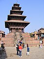 Temple of Nyatapola
 -
 Statue of a wrestler at Nyatapola temple
 -
 Woman drying rice
 -
 Nepali curd


Image: Deepankar.jpg
LALITPUR
[सम्पादन गर्नुहोस्]Lalitpur
ललितपुर उपमहानगरपालिका Patan, Yala | |
|---|---|
| Lalitpur Sub-Metropolitan City | |
 Bird's eye view of the Patan Durbar Square. It has been listed by UNESCO as a World Heritage Site. | |
| Country | |
| Zone | Bagmati Zone |
| District | Lalitpur District |
| Incorporated | 1918 |
| क्षेत्रफल | |
| • जम्मा | १५.४३ किमी२ (५.९६ वर्ग माइल) |
| जनसङ्ख्या (2011) | |
| • जम्मा | २२६,७२८ |
| • घनत्व | १५०००/किमी२ (३८०००/वर्ग माइल) |
| समय क्षेत्र | युटिसी+5:45 (Nepal Time) |
| Postal Code | 44700 |
| क्षेत्रीय सङ्केत | 01 |
| वेबसाइट | www.lalitpur.org.np |
Patan (संस्कृत: पाटन Pātan, नेवारी: यल Yala), officially Lalitpur Sub-Metropolitan City, is one of the major cities of Nepal located in the south-central part of Kathmandu Valley. Patan is also known as Manigal. It is best known for its rich cultural heritage, particularly its tradition of arts and crafts. It is called city of festival and feast, fine ancient art, making of metallic and stone carving statue. At the time of the 2011 Nepal census it had a population of 226,728 in 54,748 individual households.[९४]
Geography
[सम्पादन गर्नुहोस्]
Patan is on the elevated tract of land in Kathmandu Valley on the south side of the Bagmati River, which separates it from the city of Kathmandu on the northern and western side. The Nakkhu Khola acts as the boundary on the southern side. It was developed on relatively thin layers of deposited clay and gravel in the central part of a dried ancient lake known as the Nagdaha.
It is among the largest cities in the country, along with Kathmandu, Pokhara, and Biratnagar.
The city has an area of 15.43 square kilometres and is divided into 22 municipal wards. It is bounded by:[९५]
- East: Imadol VDC and Harisiddhi VDC
- West: Kirtipur Municipality and Kathmandu Metropolitan City (KMC)
- North: Kathmandu Metropolitan City (KMC)
- South: Saibu VDC, Sunakothi VDC and Dhapakhel VDC
Climate
[सम्पादन गर्नुहोस्]Climate is characterized by relatively high temperatures and evenly distributed precipitation throughout the year. The Köppen Climate Classification subtype for this climate is "Cfa" (Humid Subtropical Climate).[९६]
History
[सम्पादन गर्नुहोस्]Lalitpur is believed to have been founded in the third century BC by the Kirat dynasty and later expanded by Licchavis in the sixth century. It was further expanded by the Mallas during the medieval period.
There are many legends about its name. The most popular one is the legend of the God Rato Machhindranath, who was brought to the valley from Kamaru Kamachhya, located in Assam, India, by a group of three people representing the three kingdoms centered in the Kathmandu Valley.
One of them was called Lalit, a farmer who carried God Rato Machhindranath to the valley all the way from Assam, India. The purpose of bringing the God Rato Machhindranath to the valley was to overcome the worst drought there. There was a strong belief that the God Rato Machhindranath would bring rain in the valley. It was due to Lalit's effort that the God Rato Machhindranath was settled in Lalitpur. Many believe that the name of the town is kept after his name Lalit and pur meaning township.
In May, a chariot festival honoring the deity known as Bunga Dyah Jatra is held in Patan. It is the longest and one of the most important religious celebrations in Patan. During the month-long festival, an image of Rato Machhendanath is placed on a tall chariot and pulled through the city streets in stages.
Lalitpur said to have been founded by King Veer Deva in 299 AD, but there is unanimity among scholars that Patan was a well established and developed town since ancient times. Several historical records including many other legends indicate that Patan is the oldest of all the cities of Kathmandu Valley. According to a very old Kirat chronicle, Patan was founded by Kirat rulers long before the Licchavi rulers came into the political scene in Kathmandu Valley. According to that chronicle, the earliest known capital of Kirat rulers was Thankot. Kathmandu, the present capital was most possibly removed from Thankot to Patan after the Kirati King Yalamber came into power sometimes around second century AD.
One of the most used and typical Newar names of Patan is Yala. It is said that King Yalamber or Yellung Hang named this city after himself, and ever since this ancient city was known as Yala.
In 1768, Lalitpur was annexed to the Gorkha Kingdom by Prithvi Narayan Shah in the Battle of Lalitpur.
Historical monuments
[सम्पादन गर्नुहोस्]The city was initially designed in the shape of the Buddhist Dharma-Chakra (Wheel of Righteousness). The four thurs or mounds on the perimeter of Patan are ascribed around, one at each corner of its cardinal points, which are popularly known as Asoka Stupas. Legend has it that Emperor Asoka (the legendary King of India) visited with his daughter Charumati to Kathmandu in 250 BC and erected five Asoka Stupas, four in the surrounding and one at the middle of the Patan. The size and shape of these stupas seem to breathe their antiquity in a real sense. There are more than 1,200 Buddhist monuments of various shapes and sizes scattered in and around the city.
The most important monument of the city is Patan Durbar Square, which has been listed by UNESCO as one of seven Monument Zones that make up the Kathmandu Valley World Heritage Site. The seven monument zones were included in the World Heritage List in 1979 as one integrated site. The monument zones are declared as protected and preserved according to the Monuments Preservation Act of 1956.
Patan City was planned in Vihars and Bahils. Out of 295 Vihars and Bahils of the valley 56% of them are in Patan. The water conduits, stone spouts, Jaladroni (water tanks), artistic gate ways, Hindu temples and Buddhist Vihars adorn the city. The in built cultural heritage like the royal palace, with intricately carved doors and windows and beautiful courtyards adorned with exquisite icons enhance the beauty of the city. Such art pieces are found in stone, metal, terracotta ivory and other objects. All these artifacts exhibit artistic excellence of the craftsmen and the whole city looks like an open museum.
Economy
[सम्पादन गर्नुहोस्]A substantial portion of the population is engaged in trades, notably in traditional handicrafts and small scale cottage industries, and some residents work in agriculture. Lalitpur has produced the highest number of renowned artists and finest craftsmen ever recorded in the history of Nepali art.
Patan has maintained a culture of craftwork even in the face of rapid urbanization and many social and political upheavals.
The city is less urbanized than Kathmandu, north of the Bagmati river, but is home to many workshops, stores, restaurants, hotels, schools, embassies and other important sectors of the Kathmandu Valley economy.[स्रोत नखुलेको]
Buddha Air has its headquarters in Jawalakhel,[९७] near Patan.[९८]
Education
[सम्पादन गर्नुहोस्]Postsecondary education
[सम्पादन गर्नुहोस्]Patan is home to Pulchowk Engineering Campus, one of the oldest and most reputed colleges affiliated with the Institute of Engineering, Tribhuvan University. Patan Academy of Health Sciences is the only medical university in the city with Patan Hospital as its primary teaching hospital, and there is another medical school - KIST Medical College in Lalitpur.[९९] Other instituitions of higher learning in Patan include Kathmandu University School of Management(KUSOM) and Patan Multiple Campus.
Primary and secondary education
[सम्पादन गर्नुहोस्]The city is served by a number of private and public instituitions providing education from primary until secondary level. Among all, the largest and reputed schools are Adarsha Vidya Mandir, St. Xavier's School, St. Mary's, Little Angels School, Graded English Medium School,
Rato Bangala School, DAV Sushil Kedia, Adarsha Kanya Niketan, The British School and Gyanodaya Bal Batika School.
Libraries
[सम्पादन गर्नुहोस्]Nepal National Library which was established in 1957 AD was moved to Patan from Singha Durbar in 2061 AD. It is at Harihar Bhawan.[१००] Madan Puraskar Pustakalaya which awards the Madan Puraskar and Jagadamba Shree Puraskar literary prizes is in the city.
Places of interest
[सम्पादन गर्नुहोस्]
Patan is renowned as a very artistic city. Most of the Nepalese art is devoted to Gods, and there are an abundance of temples and viharas. Notable places of interest include:[१०१]
- Patan Durbar Square: The palace square and residence of the Malla rulers of Patan state which now houses a museum.
- Patan Dhoka: One of the historical entrances to the old city.
- Bhaskerdev Samskarita Hiranyabarna Mahavihara: A Buddhist temple known locally as Golden Temple.
- Mahabouddha Temple: Also known as 1000 Buddha Temple modeled liked the Mahabodhi temple in Bodh Gaya.
- Kumbheswor Temple: A Shiva temple with two ponds whose water is believed to come from Gosaikunda.
- Ratnakar Mahavihar: Also known as Ha Baha, the viahara complex is the official residence of the Kumari of Patan.
- Krishna Mandir: One of the most beautiful stone temples of Nepal built by King Siddhinarsingh Malla in the 16th century.
- Park Gallery: an artist run space founded in 1970.
Transportation
[सम्पादन गर्नुहोस्]Airports
[सम्पादन गर्नुहोस्]All international and domestic flights of Kathmandu Valley is handled by Tribhuvan International Airport which lies about 7 km from Patan City Centre.
Roads
[सम्पादन गर्नुहोस्]Walking is the easiest method of transportation within the city as the core is densely populated. In terms of motor transport, Kathmandu Valley Ring Road which encircles the central part of the valley is a strategic road in the city. Connection to Kathmandu over the Bagmati River is provided by a host of road and pedestrian bridges. The most trafficked and important bridge connecting to the centre of Kathmandu is Thapathali Bridge. Since pedestrians and vehicles often have to share the same road, traffic congestion is a major problem in Patan. Efforts are being made to widen roads to make them more suitable to vehicular traffic.[१०२]
Public transportation
[सम्पादन गर्नुहोस्]Private companies operate a number of routes connecting Patan with other places in the valley. Buses, micro-buses and electric tempos are the most common forms of public transport seen in the city. Lalitpur Yatayat buses connects the touristic Thamel area of Kathmandu with buses stopping at Patan Dhoka, a five-minute walk to Patan Durbar Square. Lagankhel Bus Park is the central transport hub.
Media[edit]
To Promote local culture Patan has one FM radio station Radio Sagarmatha - 102.4 MHz Which is a Community radio Station.
Sport
[सम्पादन गर्नुहोस्]| Club | Sport | Founded | League |
|---|---|---|---|
| Three Star Club | Football | 1974 | Martyr's Memorial A-Division League |
| Friends Club | Football | 1972 | Martyr's Memorial A-Division League |
| Jawalakhel Youth Club | Football | Martyr's Memorial A-Division League | |
| Chyasal Youth Club | Football | 1981 | Martyr's Memorial B-Division League |
Language
[सम्पादन गर्नुहोस्]The original native language of Patan is Nepal Bhasa's Lalitpur dialect. Though due to the migration form other places to Patan, other languages like Nepali, Tamang, etc. are also spoken.
Nepal]]
- ↑ "An Overview of the Central Development Region (CR)" (PDF), Internal-displacement.org, अन्तिम पहुँच नोभेम्बर २५, २०१३।
- ↑ "History", Kathmandu.gov.np, अन्तिम पहुँच १६ मे २०१०।
- ↑ "National Population and Housing Census 2011", National Planning Commission Secretariat, Central Bureau of Statistics (CBS), Government of Nepal, नोभेम्बर २०१२।
- ↑ ४.० ४.१ ४.२ ४.३ "Kathmandu Facts", Kathmandu Metropolitan City Council, Government of Nepal, अन्तिम पहुँच डिसेम्बर १२, २००९।
- ↑ ५.० ५.१ "Kathmandu Metropolitan City Office – Introduction", Kathmandu Metropolitan City Office, अन्तिम पहुँच १४ अगस्ट २०१४।
- ↑ Slusser, Mary (1982). Nepal Mandala: A Cultural Study of the Kathmandu Valley. Princeton University. ISBN 978-0-691-03128-6. Page vii.
- ↑ "The World Fact Book"Geography", Central Intelligence Agency (CIA), US, अन्तिम पहुँच नोभेम्बर २३, २००९।
- ↑ http://www.businessinsider.com/tripadvisor-says-these-are-the-hot-new-destinations-for-travelers-2013-12
- ↑ "Introduction", Kathmandu Metropolitan City, Government of Nepal, अन्तिम पहुँच २००९-१२-१२।
- ↑ Kirkpatrick, Colonel (१८११), An Account of the Kingdom of Nepaul, London: William Miller, अन्तिम पहुँच ९ मार्च २०१२। pp. 159, 162-163.
- ↑ "Contributions to Nepalese Studies", CNAS, Tribhuvan University, डिसेम्बर १९८३, अन्तिम पहुँच २८ जुलाई २०१२।
- ↑ १२.० १२.१ "सुस्त उत्खनन » पुरातत्व » सम्पदा :: नेपाल ::", Ekantipur.com, २०१०-०६-०९, अन्तिम पहुँच २०१२-०१-१५।
- ↑ Levi, Sylvain, Nepal, पृ: ५०, अन्तिम पहुँच १ डिसेम्बर २०१३।
- ↑ "History", Government of Nepal, अन्तिम पहुँच २००९-१२-१२।
- ↑ "History:Ancient Nepal", New Travels and Tours Ltd, अन्तिम पहुँच २००९-१२-१८।
- ↑ १६.० १६.१ Apr, Wed (२०१०-०४-२१), "Article:झीसं पत्याः यानाच्वनागु अन्धविश्वास – Author:विपेन्द्र महर्जन Nepalmandal", Nepalmandal.com, अन्तिम पहुँच २०१२-०१-१५।
- ↑ Article:गोपालराज वंशावली Language: Nepalbhasa, Journal:नेपालभाषा केन्द्रीय विभागया जर्नल, Edition:1, Date: 1998, Page: 18-25, 44
- ↑ "A Short History of Sanskrit Buddhist Manuscripts", Dsbcproject.org, अन्तिम पहुँच २०१३-११-२४।
- ↑ "Kathmandu Metropolitan City", Kathmandu.gov.np, अन्तिम पहुँच २०१३-११-२४।
- ↑ २०.० २०.१ "काष्ठमण्डप कि होममण्डप", Gorkhapatra.org.np, अन्तिम पहुँच २०१३-११-२४।
- ↑ "राष्ट्रपति अचानक ग्यालरीमा | कला र शैली | :: कान्तिपुर ::", Ekantipur.com, अन्तिम पहुँच २०१२-०१-१५।
- ↑ Dietrich, Angela (१९९६), "Buddhist Monks and Rana Rulers: A History of Persecution", Buddhist Himalaya: A Journal of Nagarjuna Institute of Exact Methods, अन्तिम पहुँच २४ सेप्टेम्बर २०१३।
- ↑ Lal, C. K. (१६ फेब्रुअरी २००१), "The Rana resonance", Nepali Times, अन्तिम पहुँच २४ सेप्टेम्बर २०१३।
- ↑ "Geography", Kathmandu Metropolitan City, अन्तिम पहुँच २००९-१२-१२।
- ↑ Shreshta, S.H (२००५), "Nepal in Maps", Kathmandu valley (Kathmandu: Educational Publishing House), पृ: 102–114।
- ↑ Shrestha S.H. p. 35
- ↑ Shreshta, Vinod Prasad (२००७), "A Concise Geography of Nepal", Climate (Kathmandu: Mandal Publications), पृ: 24–28, आइएसबिएन 978-99946-55-04-5।
- ↑ २८.० २८.१ "Average Temperature and Rainfall of Kathmandu City", Nepal Vista, Nepal Bureau of Standards, Weather Meteorology, अन्तिम पहुँच २००९-११-०६।
- ↑ "Normals from 1981-2010", Department of Hydrology and Meteorology (Nepal), अन्तिम पहुँच १४ अक्टोबर २०१२।
- ↑ "World Weather Information Service – Kathmandu", World Meteorological Organization, अन्तिम पहुँच अप्रिल १६, २०१३।
- ↑ Cappelen, John; Jensen, Jens, "Nepal - Kathmandu", Climate Data for Selected Stations (1931-1960) (Danishमा), Danish Meteorological Institute, पृ: १९०, अन्तिम पहुँच अप्रिल १६, २०१३।
- ↑ "Nepal - Katmandu", Centro de Investigaciones Fitosociológicas, अन्तिम पहुँच अप्रिल १६, २०१३।
- ↑ Lewis, Todd T, "Buddhism, Himalayan Trade, and Newar Merchants", अन्तिम पहुँच २८ जुलाई २०१२।
- ↑ ३४.० ३४.१ ३४.२ "Economy", Kathmandu Metropolitan City, Government of Nepal, अन्तिम पहुँच २००९-१२-२०।
- ↑ ३५.० ३५.१ ३५.२ ३५.३ "Economy", Kathmandu Metropolitan City Office, अन्तिम पहुँच २००९-१२-१८।
- ↑ ३६.० ३६.१ Shrestha pp.86–89
- ↑ "Jhamel", Nepali Times, अन्तिम पहुँच १२ मार्च २०१२।
- ↑ Shrestha pp.86–87
- ↑ "Hotels in Kathmandu", Kathmandu- hotels.com, अन्तिम पहुँच २००९-१२-१३।
- ↑ "Metropolis Council", Kathmandu Metropolitan City Council, Government of Nepal, अन्तिम पहुँच २००९-१२-१४।
- ↑ "Ward Profile", Kathmandu Metropolitan City Council, Government of Nepal, अन्तिम पहुँच २००९-१२-१४।
- ↑ ४२.० ४२.१ ४२.२ ४२.३ ४२.४ "History and problem", Firefighters Volunteer Association of Nepal (FAN), अन्तिम पहुँच २००९-१२-२०।
- ↑ "Census Nepal 2001", अन्तिम पहुँच २००९-१२-१३।[मृत कडी]
- ↑ "Population", Kathmandu Metropolitan City, Government of Nepal, अन्तिम पहुँच २००९-१२-१२।
- ↑ "National Census of Nepal 2011" (PDF), अन्तिम पहुँच २०१३-११-२४।
- ↑ ४६.० ४६.१ Jha p.21
- ↑ ४७.० ४७.१ "Festivals", Kathmandu Metropolitan City, Government of Nepal, अन्तिम पहुँच २००९-१२-१२।
- ↑ "Kathmandu Valley-Unesco World Heritage site", World Heritage- UNESCO.org, अन्तिम पहुँच नोभेम्बर २५, २००९।
- ↑ "Kathmandu Valley World Heritage site: Nepal" (PDF), Heritage Homeowner's Preservation Manual, Unesco, Kathmandu and Bangkok, २००६, अन्तिम पहुँच नोभेम्बर २५, २००९।
- ↑ "Hanuman Dhoka (Old Royal Palace)", Vegetarian-restaurants.net, अन्तिम पहुँच २००९-१२-२०।
- ↑ "Kumari Devi – The Living Goddess", Visitnepal.com, अन्तिम पहुँच २००९-१२-१९।
- ↑ "SAARC tourism", Nepal.saarctourism.org, अन्तिम पहुँच २०१०-०७-०४।
- ↑ ५३.० ५३.१ ५३.२ Mayhew, Bradley; Bindloss, Joe; Armington, Stan (२००६), Nepal, Lonely Planet, पृ: १६६, आइएसबिएन 978-1-74059-699-2।
- ↑ "SAARC tourism", Nepal.saarctourism.org, अन्तिम पहुँच २०१३-११-२५।
- ↑ "Spiritual guides", Vegetarian-restaurants.net, २००६-०१-०१, अन्तिम पहुँच २०१०-०७-०४।
- ↑ Snellgrove (1987), p. 365.
- ↑ "Fables of Boudhanath and Changunarayan", nepalnews.com, अन्तिम पहुँच २००९-१२-१३। [मृत कडी]
- ↑ ५८.० ५८.१ ५८.२ Mayhew, Bradley; Bindloss, Joe; Armington, Stan (२००६), Nepal, Lonely Planet, पृ: 170–1, आइएसबिएन 978-1-74059-699-2।
- ↑ Jha p.23
- ↑ Jha pp.23–24
- ↑ ६१.० ६१.१ "Museums and Art Galleries of Nepal", Asiatravel.com, अन्तिम पहुँच २००९-१२-१८।
- ↑ ६२.०० ६२.०१ ६२.०२ ६२.०३ ६२.०४ ६२.०५ ६२.०६ ६२.०७ ६२.०८ ६२.०९ ६२.१० ६२.११ ६२.१२ ६२.१३ ६२.१४ "Museums and art galleries", Asia Travel, अन्तिम पहुँच २००९-१२-१८।
- ↑ Woodhatch, Tom (१९९९), "Nepal handbook", The Royal Palace (Footprint Travel Guides), पृ: १९४, आइएसबिएन 978-1-900949-44-6, अन्तिम पहुँच २००९-१२-१७।
- ↑ Mayhew, Bradley; Bindloss, Joe; Armington, Stan (२००६), "Lonely Planet", The Royal Massacre (Lonely Planet), पृ: ३८, आइएसबिएन 978-1-74059-699-2, अन्तिम पहुँच २००९-१२-१७।
- ↑ Vibhaga, Nepal Sūcanā (१९७५), "Narayanhity Royal Palace, home of the King of Nepal", Royal Palace (His Majesty's Govt., Ministry of Communications, Dept. of Information), पृ: ५, अन्तिम पहुँच २००९-१२-१७।
- ↑ ६६.० ६६.१ http://www.spacesnepal.com/archives/sept_oct10/2010IJ2.php
- ↑ http://cpruscha.com/1964-1974/ceda-building-centre-for-regional-development/
- ↑ "Kathmandu Contemporary Art Centre", Kathmanduarts.org, अन्तिम पहुँच २०१०-०७-०४।
- ↑ "Theatre fest begins", The Kathmandu Post, १८ नोभेम्बर २०१०, अन्तिम पहुँच १ जनवरी २०१४।
- ↑ ७०.० ७०.१ ७०.२ Lonely Planet (2003), pp. 91–92
- ↑ Nepal, "KFC, Kathmandu - Restaurant Reviews", TripAdvisor, अन्तिम पहुँच २०१३-११-२४।
- ↑ "Nepal: A whiff of sobriety", The Economist, जुलाई २८, २०१२, अन्तिम पहुँच नोभेम्बर २५, २०१३।
- ↑ "Katmandu as a world Heritage Site", Kathmandu Metropolitan City, Government of Nepal, अन्तिम पहुँच नोभेम्बर २५, २०१३।
- ↑ L. S. Cousins (1996), "The dating of the historical Buddha: a review article", Journal of the Royal Asiatic Society (3)6(1): 57–63.
- ↑ "Churches in Nepal", Across.co.nz, अन्तिम पहुँच डिसेम्बर २०, २००९।
- ↑ "US Department of State: Diplomacy in Action", US Department of State, अन्तिम पहुँच डिसेम्बर २०, २००९।
- ↑ "Science, research and technology in Nepal" (PDF), Bajracharya, Dayanand; Bhuju, Dinesh Raj; Pokhrel, Jiba Raj. UNESCO Kathmandu Office., अन्तिम पहुँच २००९-११-१३।
- ↑ "List of medical colleges of Nepal", Medchrome.com, डिसेम्बर २६, २००९, अन्तिम पहुँच जनवरी १५, २०१२।
- ↑ "Goal Programme – All-Nepal Football Association – 2001", FIFA, अन्तिम पहुँच २००९-१२-२०।
- ↑ Shrestha pp.91–96
- ↑ ८१.० ८१.१ http://www.caanepal.org.np/tia.htm [मृत कडी]
- ↑ http://www.turkishairlines.com/en-int/corporate/news/news/turkish-airlines-launches-a-new-route-to-kathmandu
- ↑ Ramon Magsaysay Award Foundation, "Ramon Magsaysay Award Foundation", Rmaf.org.ph, अन्तिम पहुँच नोभेम्बर २४, २०१३।
- ↑ "healio", Healio, मे २००७, अन्तिम पहुँच नोभेम्बर २४, २०१३।
- ↑ "Prince Mahidol Award", Prince Mahidol Award, मे ५, २००९, अन्तिम पहुँच नोभेम्बर २४, २०१३।
- ↑ "MyRepublica and IHT enter into publishing alliance, to publish Asia pacific edition of IHT", MYRepublica, अन्तिम पहुँच फेब्रुअरी १०, २०१२।
- ↑ "Nepal Country Profile", British Broadcasting Corporation (BBC), २००९-०८-१९, अन्तिम पहुँच २००९-१२-२२।
- ↑ "Outline of International Relations of Kathmandu Metropolitan City" (PDF), Katamandu Metropolitan City, Government of Nepal, अन्तिम पहुँच डिसेम्बर २०, २००९।
- ↑ "Twin towns and Sister cities of Minsk [via WaybackMachine.com]" (Russianमा), The department of protocol and international relations of Minsk City Executive Committee, मूलबाट २ मे २०१३-मा सङ्ग्रहित, अन्तिम पहुँच २०१३-०७-२१।
- ↑ City Population [१]. Retrieved: 9 Dec, 2011.
- ↑ ९१.०० ९१.०१ ९१.०२ ९१.०३ ९१.०४ ९१.०५ ९१.०६ ९१.०७ ९१.०८ ९१.०९ ९१.१० ९१.११ ९१.१२ Destination Nepal: Bhaktapur [२]. Retrieved: 9 Dec, 2011.
- ↑ "UNESCO"।
- ↑ ९३.० ९३.१ "Introducing Changu Narayan Temple", अन्तिम पहुँच २००९-१२-१९।
- ↑ National Population and Housing Census, Government of Nepal, २०११, पृ: 41।
- ↑ "Welcome to Official Site of Lalitpur Sub-Metropolital City Office, Nepal ::", Lalitpur.org.np, अन्तिम पहुँच २०११-०५-२२।
- ↑ Climate Summary for Patan, Nepal
- ↑ "Domestic/International." Buddha Air. Retrieved on 26 September 2011. "The company headquarters is located at Jawalakhel, Lalitpur"
- ↑ "Contact Information." Buddha Air. Retrieved on September 25, 2011. "Buddha Air Pvt. Ltd Pulchowk Rd Patan"
- ↑ "About PAHS", Patan Academy of Health Sciences, अन्तिम पहुँच २९ जुन २०१२।
- ↑ "NNL: About Us", Nepal National Library, अन्तिम पहुँच ३० जुन २०१२।
- ↑ "Historical Monuments", Lalitpur Sub-Metropolitan City, अन्तिम पहुँच २०१२-०६-२९।
- ↑ "After Kathmandu, Lalitpur road expansion starts", Katipur Media, अन्तिम पहुँच १ जुलाई २०१२।