बेलायती समुद्रपार क्षेत्र
बेलायती समुद्रपार क्षेत्र | |
|---|---|
| Anthem: "गड सेभ द किङ" | |
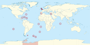
 संयुक्त अधिराज्य र बेलायती समुद्रपार क्षेत्रको अवस्थिति | |
| सार्वभौम राज्य | संयुक्त अधिराज्य |
| सबैभन्दा ठुलो क्षेत्र | बेलायती अन्टार्क्टिक क्षेत्र |
| Official languages | अङ्ग्रेजी |
| Demonym(s) | |
| Government | संवैधानिक राजतन्त्र अन्तर्गत स्वशासित प्रशासन |
• शासक | चार्ल्स तृतीय |
| ऋषि सुनक | |
| जेम्स क्लेभर्ली | |
• समुद्रपार क्षेत्र र दिगो विकासका लागि संसदीय मातहतका सचिव | खाली (२५ नोभेम्बर २०२० सम्म) |
| Area | |
• Total | १८,०१५ किमी२ (६,९५६ वर्ग माइल) |
| Population | |
• सन् २०१९ estimate | २,७२,२५६ |
| Date format | दिन/महिना/वर्ष |
बेलायती समुद्रपार क्षेत्र वा संयुक्त अधिराज्यको समुद्रपार क्षेत्र, संयुक्त अधिराज्यसँग संवैधानिक र ऐतिहासिक सम्बन्ध भएका चौध क्षेत्रहरू हुन्।[१][२] तिनीहरू पूर्व बेलायती साम्राज्यका अन्तिम अवशेष हुन् र उक्त क्षेत्रहरू संयुक्त अधिराज्यको भाग होइनन्। स्थायी बसोबास भएका क्षेत्रहरू आन्तरिक स्वशासित छन्। संयुक्त अधिराज्यले रक्षा र विदेशी सम्बन्धको जिम्मेवारी कायम राखेको छ। तीनवटा इलाकामा सैनिक वा वैज्ञानिक कर्मचारीहरूको क्षणिक जनसङ्ख्या मात्र छ। बाँकी मध्ये एक बाहेक सबैलाई संयुक्त राष्ट्र सङ्घको विशेष समितिले उपनिवेशीकरणसम्बन्धी गैर-शासित इलाकाको रूपमा सूचीबद्ध गरेको छ। चौध वटा राज्य प्रमुखको रूपमा बेलायतका राजा रहेका छिन्। [३]
अप्रिल २०१८ सम्म, तीन क्षेत्रहरू (साइप्रस द्वीपमा अक्रोत्तिरी र धेकेलिया फल्कल्यान्ड द्वीप, जिब्राल्टर र सार्वभौम आधार क्षेत्रहरू) युरोप र अमेरिकाका लागि राज्य मन्त्रीको जिम्मेवारी रहेका छन्। बाँकी भूभागका लागि जिम्मेवार मन्त्री विदेशी भूभाग र दिगो विकासका लागि संसदीय उपसचिव हुन्।[४] सन् २०२१ सम्म सबैभन्दा बढी जनसङ्ख्या भएको बेलायती विदेशी भूभाग केम्यान टापु हो। यसको जनसङ्ख्या ६९,६५६ रहेको छ।[५]
हालका क्षेत्रहरू
[सम्पादन गर्नुहोस्]१४ वटा क्षेत्रहरू यस प्रकार छन् :[६]
| झण्डा | निशान छाप | नाम | अवस्थिति | लक्ष्य | क्षेत्रफल | कुल ग्राहस्थ उत्पादन (साङ्केतिक) |
कुल ग्राहस्थ उत्पादन प्रतिव्यक्ति आय (साङ्केतिक) |
जनसङ्ख्या | राजधानी | टिप्पणी |
|---|---|---|---|---|---|---|---|---|---|---|
| एङ्गुइला | क्यारिबियन, उत्तरी आन्ध्र महासागर | "एकता, बल र सहनशीलता" | ९१ किमी२ (३५.१ वर्ग माइल)[७] | $299 million | $२०,३०७ | 14,869 (सन् २०१९ अनुमानित)[८] | द भ्याली | |||
| बर्मुडा | आजोरेस, क्यारिबियन, क्यानडाको केप सेबल टापु र संयुक्त राज्य अमेरिकाको केप ह्याटरस (यसको सबैभन्दा नजिकको छिमेकी) बीच उत्तरी आन्ध्र महासागर | "Quo fata ferunt" (ल्याटिन; (अनुवादित = भाग्यले कहाँ पुर्याउँछ) | ५४ किमी२ (२०.८ वर्ग माइल)[९] | $6.464 billion | $102,987 | 62,506 (सन् २०१९ अनुमानित)[१०] | ह्यामिल्टन | |||
| बेलायती अन्टार्क्टिक क्षेत्र | अन्टार्क्टिका | "अनुसन्धान र खोज" | १७,०९,४०० किमी२ (६,६०,००० वर्ग माइल)[७] | 0 जाडोमा ५० जना जति र गर्मीमा ४०० वढी (अनुसन्धानकर्मी)[११] |
रोथेरा (मुख्य आधार) | |||||
| बेलायती हिन्द महासागर क्षेत्र | हिन्द महासागर | "In tutela nostra Limuria" | ६० किमी२ (२३ वर्ग माइल)[१२] | 0 ३,००० अस्थायी (बेलायती र अमेरिकी सैन्य कर्मचारी; अनुमानित)[१३] |
डिएगो गार्सिया अनुसन्धान केन्द्र (आधार) | मौरिससद्वारा दावी गरिएको | ||||
| बेलायती भर्जिन टापु | क्यारिबियन, उत्तर आन्ध्र महासागर | "Vigilate" (ल्याटिन | १५३ किमी२ (५९ वर्ग माइल)[१४] | $१.०५ अर्ब | $४८,५११ | 31,758 (2018 census)[१५] | रोड टाउन | |||
| केम्यान टापु | क्यारिबियन | "He hath founded it upon the seas" | २६४ किमी२ (१०१.९ वर्ग माइल)[१६] | $4.298 billion | $85,474 | 69,656 (सन् २०२१ को जनगणना)[१६] | जर्ज टाउन | |||
| फल्कल्यान्ड टापु | दक्षिण आन्ध्र महासागर | "अधिकारको चाहना" | १२,१७३ किमी२ (४,७०० वर्ग माइल)[९] | $164.5 million | $70,800 | 3,377 (2019 estimate)[१७] 1,350 non-permanent (UK military personnel; 2012 estimate) |
Stanley | अर्जेन्टिनाद्वारा दाबी। सन् १९८२ मा यी टापुको नियन्त्रणको लागि अर्जेन्टिना र संयुक्त अधिराज्य बीच फल्कल्यान्ड युद्ध भएको थियो। | ||
| जिब्राल्टार | इबेरिया प्रायद्वीप, महाद्विपीय युरोप | "Nulli expugnabilis hosti" (Latin; "कुनै पनि शत्रुले हामीलाई देश निकाला गर्न सक्दैन") | ६.५ किमी२ (२.५ वर्ग माइल)[१८] | $३.०८ अर्ब | $९२,८४३ | 33,701 (सन् २०१९ अनुमानित)[१९] १,२५० अस्थायी (सैन्य शक्ति; सन् २०१२ अनुमानित) |
Gibraltar | Claimed by Spain. | ||
| मोन्टसेराट | क्यारिबियन, उत्तरी आन्ध्र महासागर | "A people of excellence, moulded by nature, nurtured by God" | १०१ किमी२ (३९ वर्ग माइल)[२०] | $६.१ करोड | $१२,१८१ | 5,215 (सन् २०१९ जनगणना)[२१] | प्लाइमाउथ (de jure, but abandoned due to Soufrière Hills volcanic eruption. De facto capital is Brades) | |||
| Pitcairn, Henderson, Ducie and Oeno Islands | प्रशान्त महासागर | ४७ किमी२ (१८ वर्ग माइल)[२२] | $144,715 | $2,894 | 50 (2018 estimate)[२३] 6 non-permanent (2014 estimate)[२४] |
Adamstown | ||||
| Saint Helena, Ascension and Tristan da Cunha, including: |
South Atlantic Ocean | ४२० किमी२ (१६२ वर्ग माइल) | $55.7 million | $12,230 | 5,633 (total; 2016 census) | Jamestown | ||||
| Saint Helena | "Loyal and Unshakeable" (Saint Helena) | 4,349 (Saint Helena; 2019 census)[२५] | ||||||||
| Ascension Island | 880 (Ascension; estimate)[२६] 1,000 non-permanent (Ascension; UK military personnel; estimate)[२६] |
|||||||||
| Tristan da Cunha | "Our faith is our strength" (Tristan da Cunha) | 300 (Tristan da Cunha; estimate)[२६] 9 non-permanent (Tristan da Cunha; weather personnel) |
||||||||
| South Georgia and the South Sandwich Islands | South Atlantic Ocean | "Leo terram propriam protegat" (Latin; "Let the lion protect his own land") | ३,९०३ किमी२ (१,५०७ वर्ग माइल)[२७] | 0 99 non-permanent (officials and research personnel)[२८] |
King Edward Point | Claimed by Argentina. The islands were occupied by Argentina during the Falklands War in 1982. | ||||
| Sovereign Base Areas of Akrotiri and Dhekelia | Cyprus, Mediterranean Sea | २५५ किमी२ (९८ वर्ग माइल)[२९] | 7,700 (Cypriots; estimate) 8,000 non-permanent (UK military personnel and their families; estimate) |
Episkopi Cantonment | ||||||
| Turks and Caicos Islands | Lucayan Archipelago, North Atlantic Ocean | ९४८ किमी२ (३६६ वर्ग माइल)[३०] | $1.077 billion | £28,589 | 38,191 (2019 estimate)[३१] | Cockburn Town | ||||
| समग्रमा | अन्दाजी 1,727,415 km2 [स्रोत नखुलेको] |
अन्दाजी $१६.५५ अर्ब | अन्दाजी 272,256[३२] | |||||||
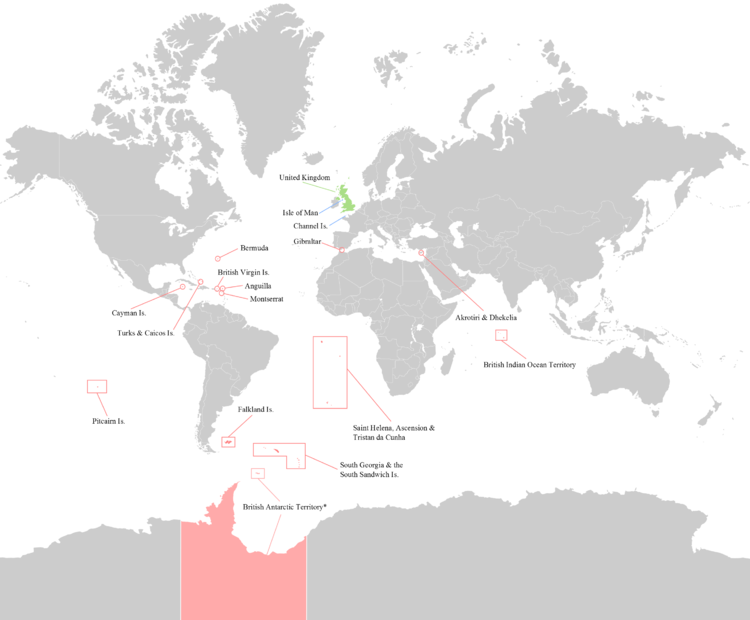
नक्सा
[सम्पादन गर्नुहोस्]
सन्दर्भ सामग्रीहरू
[सम्पादन गर्नुहोस्]- ↑ "Supporting the Overseas Territories", UK Government, मूलबाट ६ अक्टोबर २०१४-मा सङ्ग्रहित, अन्तिम पहुँच ८ नोभेम्बर २०१४।
- ↑ "British Overseas Territories Law", Hart Publishing, मूलबाट २१ जुन २०२०-मा सङ्ग्रहित, अन्तिम पहुँच १९ जुन २०२०, "Most, if not all, of these territories are likely to remain British for the foreseeable future, and many have agreed modern constitutional arrangements with the British Government." वेब्याक मेसिन अभिलेखिकरण २१ जुन २०२० मिति
- ↑ "What is the British Constitution: The Primary Structures of the British State", The Constitution Society, मूलबाट ६ अक्टोबर २०१४-मा सङ्ग्रहित, अन्तिम पहुँच १५ नोभेम्बर २०१४। वेब्याक मेसिन अभिलेखिकरण ६ अक्टोबर २०१४ मिति
- ↑ "New ministerial appointments at the Foreign and Commonwealth Office" (प्रेस विज्ञप्ति), Foreign and Commonwealth Office, १९ जुलाई २०१६, मूलबाट ५ अक्टोबर २०१६-मा सङ्ग्रहित, अन्तिम पहुँच २० सेप्टेम्बर २०१६।
- ↑ "British Overseas Territories", ७ जुन २०२१।
- ↑ "Overseas Territories", UK Overseas Territories Foreign & Commonwealth Office, मूलबाट ५ अगस्ट २००२-मा सङ्ग्रहित, अन्तिम पहुँच ८ डिसेम्बर २०१०। वेब्याक मेसिन अभिलेखिकरण ५ अगस्ट २००२ मिति
- ↑ ७.० ७.१ "British Antarctic Territory", Jncc.gov.uk, मूलबाट १४ डिसेम्बर २०१३-मा सङ्ग्रहित, अन्तिम पहुँच ८ डिसेम्बर २०१०। वेब्याक मेसिन अभिलेखिकरण १४ डिसेम्बर २०१३ मिति
- ↑ "Anguilla Population 2019", मूलबाट १० अगस्ट २०१९-मा सङ्ग्रहित, अन्तिम पहुँच १८ अगस्ट २०१९।
- ↑ ९.० ९.१ "UNdata | record view | Surface area in km2", United Nations, ४ नोभेम्बर २००९, मूलबाट ९ जुलाई २०१३-मा सङ्ग्रहित, अन्तिम पहुँच ८ डिसेम्बर २०१०।
- ↑ "Bermuda Population 2019", मूलबाट १६ अगस्ट २०१९-मा सङ्ग्रहित, अन्तिम पहुँच १८ अगस्ट २०१९।
- ↑ "Commonwealth Secretariat – British Antarctic Territory", Thecommonwealth.org, मूलबाट ५ जुन २०११-मा सङ्ग्रहित, अन्तिम पहुँच ८ डिसेम्बर २०१०।
- ↑ "British Indian Ocean Territory", Jncc.gov.uk, मूलबाट १३ अक्टोबर २०१०-मा सङ्ग्रहित, अन्तिम पहुँच ८ डिसेम्बर २०१०। वेब्याक मेसिन अभिलेखिकरण २५ डिसेम्बर २०१८ मिति
- ↑ "Commonwealth Secretariat – British Indian Ocean Territory", Thecommonwealth.org, मूलबाट ५ जुन २०११-मा सङ्ग्रहित, अन्तिम पहुँच ८ डिसेम्बर २०१०।
- ↑ "British Virgin Islands (BVI)", CIA World Factbook, मूलबाट ९ जनवरी २०२१-मा सङ्ग्रहित, अन्तिम पहुँच १४ अगस्ट २०१९।
- ↑ "British Virgin Islands (BVI)", १३ अक्टोबर २०१०, मूलबाट १३ अक्टोबर २०१०-मा सङ्ग्रहित। वेब्याक मेसिन अभिलेखिकरण १३ अक्टोबर २०१० मिति
- ↑ १६.० १६.१ "Economics and Statistics Office - Labour Force Survey Report Spring 2018", www.eso.ky, Cayman Islands Economics and Statistics Office, अगस्ट २०१८, मूलबाट १३ नोभेम्बर २०१८-मा सङ्ग्रहित, अन्तिम पहुँच २६ नोभेम्बर २०१८।
- ↑ "Falkland Islands Population 2019", मूलबाट ७ अगस्ट २०१९-मा सङ्ग्रहित, अन्तिम पहुँच १८ अगस्ट २०१९।
- ↑ "Gibraltar", Jncc.gov.uk, मूलबाट १७ डिसेम्बर २०१३-मा सङ्ग्रहित, अन्तिम पहुँच ८ डिसेम्बर २०१०। वेब्याक मेसिन अभिलेखिकरण १७ डिसेम्बर २०१३ मिति
- ↑ "Gibraltar Population 2019", मूलबाट २५ अगस्ट २०१९-मा सङ्ग्रहित, अन्तिम पहुँच १८ अगस्ट २०१९।
- ↑ "Montserrat", CIA World Factbook, मूलबाट १४ मार्च २०२१-मा सङ्ग्रहित, अन्तिम पहुँच १४ अगस्ट २०१९।
- ↑ "Montserrat", १३ अक्टोबर २०१०, मूलबाट १३ अक्टोबर २०१०-मा सङ्ग्रहित। वेब्याक मेसिन अभिलेखिकरण १३ अक्टोबर २०१० मिति
- ↑ "Pitcairn Island", Jncc.gov.uk, मूलबाट १३ अक्टोबर २०१०-मा सङ्ग्रहित, अन्तिम पहुँच ८ डिसेम्बर २०१०। वेब्याक मेसिन अभिलेखिकरण २५ डिसेम्बर २०१८ मिति
- ↑ "Pitcairn Islands Tourism | Come Explore... The Legendary Pitcairn Islands", Visitpitcairn.pn, मूलबाट १९ सेप्टेम्बर २०१९-मा सङ्ग्रहित, अन्तिम पहुँच ३ जनवरी २०१८।
- ↑ "Pitcairn Residents" वेब्याक मेसिन अभिलेखिकरण ७ डिसेम्बर २०१४ मिति. puc.edu. Retrieved 7 September 2016.
- ↑ "St Helena Government", St Helena Government, ३० जुलाई २०१९, मूलबाट ७ अगस्ट २०१९-मा सङ्ग्रहित, अन्तिम पहुँच १४ अगस्ट २०१९।
- ↑ २६.० २६.१ २६.२ "St Helena, Ascension, Tristan da Cunha profiles", BBC, १६ मार्च २०१६, मूलबाट ३० मे २०१६-मा सङ्ग्रहित, अन्तिम पहुँच २५ जुन २०१६।
- ↑ South Georgia and South Sandwich Islands वेब्याक मेसिन अभिलेखिकरण १५ जनवरी २०२१ मिति. द वर्ल्ड फ्याक्टबुक। केन्द्रीय गुप्तचर संस्था।
- ↑ "Population of Grytviken, South Georgia and the South Sandwich Islands", Population.mongabay.com, ३१ मार्च २००९, मूलबाट १७ जुलाई २०११-मा सङ्ग्रहित, अन्तिम पहुँच ८ डिसेम्बर २०१०।
- ↑ "SBA Cyprus", Jncc.gov.uk, मूलबाट १३ अक्टोबर २०१०-मा सङ्ग्रहित, अन्तिम पहुँच ८ डिसेम्बर २०१०। वेब्याक मेसिन अभिलेखिकरण २५ डिसेम्बर २०१८ मिति
- ↑ "Turks and Caicos Islands", Encyclopedia Britannica।
- ↑ "Turks and Caicos Islands Population 2019", मूलबाट १० अगस्ट २०१९-मा सङ्ग्रहित, अन्तिम पहुँच १८ अगस्ट २०१९।
- ↑ उद्दरण त्रुटी: अवैध
<ref>चिनो;HCFAC 2019नामको सन्दर्भका लागि कुनै पाठ प्रदान गरिएको छैन


